
Does Flood Geology explain the rocks in the Grand Canyon?
Reply to Dr. Snelling’s Response, Part 2
Tonto Depositional Processes and Rates
Stephen Mitchell and Kennen Tillman
Introduction
Christians have different interpretations of the Biblical doctrine of creation and how to integrate our understandings of scripture and scientific data. As part of that discussion, in 2024, we published a three-part critique of Dr. Andrew A Snelling’s papers that proposed to explain the Cambrian-aged Tonto Group in the Grand Canyon as having formed and deformed during Noah’s flood (Mitchell and Tillman 2024a, 2024c, 2024b). (Link to critique.) Dr Snelling has now published his response, also in three parts in “Answers in Depth”, a publication by Answers in Genesis (AIG). Links to his response articles are here:
Responding to “Peaceful Science” Critics on Grand Canyon Evidence, Part 1
Tonto Depositional Processes and Rates: Responding Again to “Peaceful Science” Critics, Part 2
The Tonto Deformation: Responding Again to “Peaceful Science” Critics, Part 3
In turn, we here will provide readers with a reply to this response. We hope to clarify a number of misconceptions and misrepresentations and let the readers make up their own minds.
Our response to Dr. Snelling’s articles was in three parts, as was his reply. This counter response also has three sections. First, we reply to his Part 1, in particular to: 1. concerns about who we are, 2. his interpretation of the Great Unconformity, and 3. Radiometric dating, a topic only briefly discussed in our articles.
In Part 2, we will look at the objections to our article on the deposition of the Tonto group and how long it took for it to be laid down.
Table of Contents
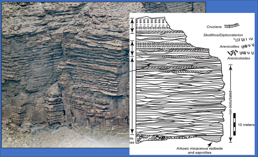 Photograph of Tapeats outcrop along North Rim of the Grand Canyon with the idealized Tapeats section from Dr. Eben Rose's 2006 article, "Nonmarine aspects of the Cambrian Tonto Group of the Grand Canyon, USA, and broader implications"
Reply to Part 2
Tonto Depositional Processes and Rates: Responding Again to “Peaceful Science” Critics, Part 2
Not surprisingly, Snelling found disagreements with our paper on the Tonto depositional processes and rates. In his model, most of the Phanerozoic record, representing sediment columns miles thick, was laid down in one year. That dictates enormous rates and eliminates many processes and depositional systems. If any bed or set of beds took longer to form than the one-year timeframe, then they cannot be considered as part of deposits from Noah’s flood. Thus, flood geology must provide evidence to support this. In fact, as Snelling hypothesizes and we pointed out in our article, the flood geology timeline means that individual formations and units had to form over just days. This has to further constrain the rates and types of processes that can be considered. We are not saying that no catastrophic processes were involved in the deposition of the Tonto group or its equivalents elsewhere, but are assessing if the evidence really supports that all of it was. Geologists recognize that catastrophic processes have acted in Earth’s history. Thus, if we could affirm that they could account for the Tonto group, it would not follow that other formations deposited by different processes were also deposited at the same rates. For instance, whatever rates and processes laid down the Tonto group were markedly different from those that formed the thick salt, gypsum and carbonate units in the Permian Basin interpreted to have been formed in ancient sabkhas (salt flats). Rapid deposition in the Tonto Group would not tell us the rates the Permian units were laid down at.
Dr. Snelling makes a series of complaints regarding our papers that come down to either: 1. we would accept his views if we just had read more of the flood geology literature or 2. “we weren’t there”. Here are examples:
“And if Mitchell and Tillman had read the Flood geology literature, they would know that during the global Flood cataclysm, rapid-fire devastating earthquakes were generating multitudes of rapidly consecutive humungous tsunamis that surged right across continents, which have been modeled to demonstrate the Tapeats Sandstone and all the overlying units could easily have been deposited within the Flood year” (Snelling 2026b)
This claim assumes that we have not read the voluminous YEC literature. We have read much, but it would be hard to read all of it. It also assumes that if we had read flood geology literature, we would find it convincing. Would we really “know” that during the flood rapid-fire earthquakes were generating multitudes of rapidly consecutive humongous tsunamis?
YEC Flood Modeling
Dr. Snelling writes:
“Furthermore, Flood geologists have demonstrated by their modeling of ocean water conditions during the global Flood cataclysm that global tides resonated to increase their ranges, super hurricanes were generated by the very warm ocean waters, and humungous tsunamis were generated repeatedly in rapid succession by super-powerful earthquakes as plates moved against one another in lock-steps due to catastrophic plate tectonics” (Snelling 2026b)
This is a great example where we have read many of the key articles and listened to supportive videos and found the catastrophic plate tectonic model unbelievable. The issue is that when we do read the flood geology literature, we find major problems. For example, the individual Dr. Snelling cites, Dr. John Baumgardner (2018a, 2018b; J. R. Baumgardner and Novarro 2023), as having “demonstrated by their modeling” that “rapid-fire devastating earthquakes were generating multitudes of rapidly consecutive humungous tsunamis that surged right across continents” never demonstrated what Snelling is claiming. Dr. Snelling wrote:
“Furthermore, Mitchell and Tillman note my reporting of the modeling research done by Flood geophysicist John Baumgardner on the catastrophic cavitation that could have eroded the needed clastic sediments (sand, silt, mud) and the humungous tsunamis that could have transported and deposited those sediments, but they omit or ignore his most recently published modeling research.” (Snelling 2026b)
Given that our article was written in 2023, as was Dr. Baumgartner’s latest article, it is not surprising that we did not include this in our article. We appreciate that John Baumgardner has put in much effort to find a scenario that could conceivably provide a mechanism for the claims by flood geologists. The abstract for his 2023 article begins this way:
“A major challenge for Flood geology is providing a credible explanation for how the staggering volume of fossil-bearing sediment was eroded, transported, and deposited in orderly patterns on the surface of the normally high-standing continents in only a few months’ time.” (J. R. Baumgardner and Novarro 2023)
We certainly agree with this statement. Baumgardner and Novarro use a computer model, but that in itself proves nothing. They input the paths for the tectonic movements that were published by conventional paleogeographers, Dr. Christopher Scotese (2021) and Dr. Ronald Blakey. (2018). It is interesting that they use this data, though Baumgardner would not accept much of what supports it. As they use positions and movement based on Scotese and Blakey’s work, it is not surprising that the program erodes and deposits sediment in areas that are somewhat similar to what is shown in maps by Scotese and Blakey.
Baumgardner assumes the effect of process of cavitation caused by tsunamis on continents to generate tremendous amounts of sediment. This is a large assumption that does not seem to be supportable. For such an explanation to be viable, it would need to generate a wide variety of sediments that would somehow be separated into beds of very different lithologies. It would need to transform granite into well-sorted sandstones, siltstones and clay-rich shales. It would need to generate lime muds for limestones, dolomitic muds for dolomite (or dolostones), halite for salt formations, gypsum and anhydrite for beds of these rocks, and plant material for coal beds. Most of these are totally missing in Baumgarner’s models.
Baumgarner states:
“We recognize that it is difficult to imagine how feldspar in the continental crustal bedrock, even when reduced by cavitation to 0.063 mm particle sizes and smaller, might be transformed to clay minerals in the brief time span available during the Flood. We acknowledge that a significant portion of the clay in the shales and mudstones in the Phanerozoic sediment record may well have been derived from shales and mudstones of the pre-Flood earth.” (J. R. Baumgardner and Novarro 2023)
We would suggest that this is inadequate. Cavitation is the complex physical interaction between collapsing vapor bubbles and solid particles in fluid flows. It is recognized as only a minor process in modern rivers (P. A. Carling et al. 2017), but then what other choice does he have?
How does he deal with the heat generated by the processes? Generating huge amounts of new crust automatically brings with it tremendous amounts of heat, and if this happened in a short time, then what happened to the heat?
Baumgardner wrote:
“The elevated temperature profile of thin, newly formed ocean lithosphere makes it effectively unsubductable. Were hot lithosphere to cover the entire ocean bottom, subduction would cease and the CPT process would come to an abrupt halt. This illustrates the imperative of a vast amount of active supernatural cooling of the ocean lithosphere during the Flood." (J. R. Baumgardner and Novarro 2023) Emphasis added.
This cooling by miraculous means would have been in addition to the cooling essential because of their proposal of accelerated radiometric decay and also the heat generated as the rapidly moving continents were slowed down. Overall, Baumgartner’s proposal seems to be an attempt to model a miracle. It is a proposal by faith in scientific wrappings. It was generated by a computer and has equations and numerical values and this will make it accepted by many who cannot really evaluate it.
These models propose a large set of unproven hypotheses that lead to continents moving at meters per second for months and generating sediment flows that traveled at the same or higher speeds. Even if we thought that the mathematical simulations were feasible, so much evidence contradicts them.
Eyewitnesses and Thin Sections
What about eyewitness testimony? Dr, Snelling wrote:
“But how can they be so sure when no geologists were present to witness the deposition of the many sandy layers of the Tapeats Sandstone?” (Snelling 2026b)
The fact is that neither of us were there. Both we and Dr. Snelling are claiming that the rocks are telling us the truth about how they were deposited. When we look at the rocks, we try to integrate all of the data and learn what is the best explanation for how they were formed. In this case, we are not claiming to have many of the details about how they were laid down, but can rule out some proposals, including the claim that they were deposited in a few days or weeks.
Dr. Snelling objected to our statement that thin sections do not tell us the depositional processes or rates. He wrote:
“Their latter claim is absolutely false! Any seasoned sedimentary petrologist will adamantly assert that microscopic descriptions of the mineralogy, grain sizes, grain shapes, pores, and textures are all highly relevant to deciphering the depositional processes and rates. Why then do all sedimentary petrology textbooks contain so many photomicrographs of sedimentary rocks and their textures?” (Snelling 2026b)
It is probably worth clarifying a bit. Our statement did particularly address sandstones as this is the subject here. Thin sections are often useful in carbonates and evaporites, though often they are not required. They are however critical for sandstones to understand the post-depositional diagenetic history. Why do petrology textbooks contain so many photomicrographs? Because they are teaching petrology, not depositional environments. Sandstone petrology focuses on the composition and provenance of the mineral grains themselves and then largely on their post-depositional history. In my copy of Dr. Sam Boggs, Jr’s book, “Petrology of Sedimentary Rocks”, I find very little on depositional processes in it, particularly for clastics (sandstones and other rocks composed of transported grains) (Boggs 2009). Grain size and sorting are important, but normally hand lens examination is adequate in regard to identifying depositional processes and rates.
How vital are thin sections in identifying depositional environments and processes? I (Steve) pulled a few books off of my shelves to see: Scholle and Spearing (1982); Brookfield and Ahlbrandt (2000); Walker and James (1992); Davis and Dalrymple (2012); Prothero and Schwab (2013).
AAPG “Sandstone Depositional Environments” - 404 pages, over 500 photos: 1 thin section photo, 0 SEM photos
Brookfield “Eolian Sediments” - 670 pages: 6 thin section photos, 8 SEM photos
Davis: “Principles of Tidal Sedimentology”- 624 photos: 1 article on carbonates with 18 photos, primarily on oolites
Walker and James “Facies Models” 409 pages: 0 thin section photos, 0 SEM photos
Prothero “Sedimentology Geology: Petrology of clastics chapter with over 20 thin section photos and 4 SEM photos, none in the section on clastic depositional environments. Many slide photos are found in the carbonate sections.
If thin sections are not that diagnostic, how would we learn the depositional processes and rates? Larger features are critical, including: sedimentary structures, the architecture of sandstone bodies and the map patterns of the distribution of features. Interpretations ought to make sense with all characteristics known regionally. Even so, a few features are relatively diagnostic, and we will consider some of these. Sand size distributions and the bedforms of sediments deposited by wind or moving water often form in predictable patterns, as demonstrated in laboratory flume experiments and in studies of recent deposits where the processes were observed. These give us tools to use in examining ancient deposits to characterize their deposition.
We will reply to the objections from Dr. Snelling, grouping the topics in this way:
-
- Things we would expect to find, but didn’t
- Things found that we would not have expected to find
Things we would expect to find, but didn’t
Dr. Snelling is correct that we were not there. Just as he references studies of sedimentary bedforms and other characteristics, he recognizes that the sedimentary bedforms that we find or don’t find, do tell us about the depositional processes, even though we weren’t there (Snelling 2022). Dr. Snelling provides key hypotheses that the rock record can be checked against. He hypothesizes velocities of water currents, and provides duration predictions that dictate average sedimentation rates. These in turn dictate a range in what should be the dominant bedforms through whatever he calls flood deposits. This is not about an interpretation of scripture. It is about does the rock record fit flood geologist’s claims.
If the Tonto Group was deposited in a short period by catastrophic processes, we continue to believe that the sediments should reflect this. As noted earlier, Snelling does believe that information from modern processes is useful in assessing the ancient record, such as when he notes that mica flakes are rare in modern eolian deposits. He reports differences between what are found in modern environments vs. the Tonto characteristics. If he can use the modern as a contrast, then the modern is a key means of understanding what is or is not in the ancient record. Of course, a global catastrophic flood would be of a different scale, but there would have been key similarities and some processes just would not have been involved. There is no reason to believe that God suspended the normal physics of how sediments were transported.
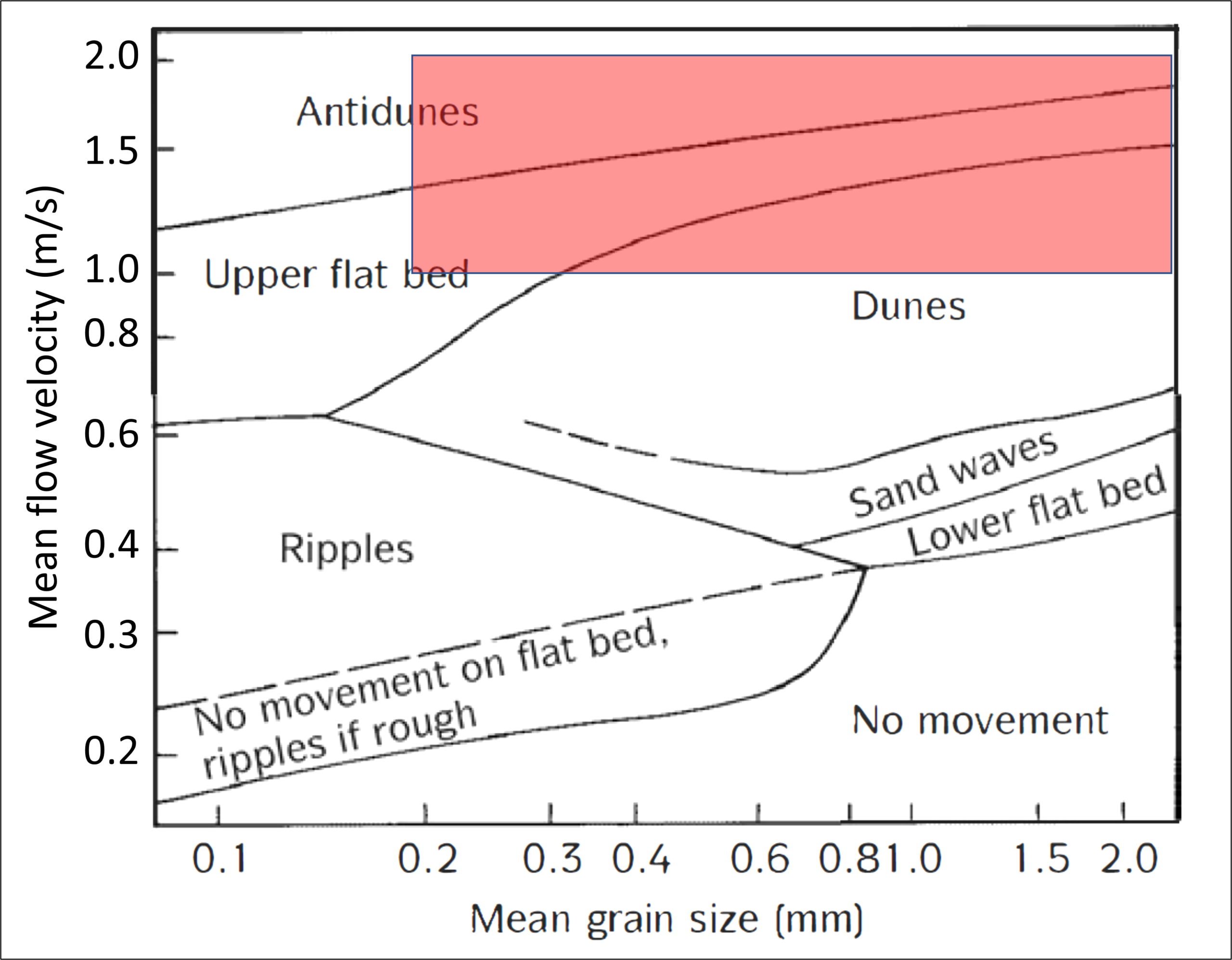
Cross-bedding is a common sedimentary structure noted by every observer of the Tapeats Sandstone and Bright Angel Formation. Are what we observe (or don’t observe) consistent with the flow rates predicted by flood geology? Planar and trough cross-bedding are common today in many settings. However, the sand bodies and the internal laminations still give us information around how the beds were formed. Sand deposition from moving water forms characteristic bedforms based on the sediment size and velocity. There is no reason to expect that God would have set special rules for flood waters. Snelling gave an estimated “water flow speed of >2 m/sec”, presumably as some sort of overall average (Snelling 2021b, 241). For the Tapeats, he predicted that flows “ranged from 1.5 m/sec in the lower parts to 1 m/sec in cross-bedded units (Snelling 2021b, 241). We can compare his predictions with tests where we know the flow rates. (Figure 2). If these were large flows moving at the predicted velocities, then one would expect that the original bedforms were antidunes, upper flat bed (one type of parallel laminations) and dunes. Antidunes are described here: Antidune Lithofacies. Few observers report upper flow regime features such as antidunes or parting laminations. All do report low flow regime portions.
(Figures are numbered based on full document)
Figure 2: Relationship between sediment size, velocity and bedforms from physical model studies known as flume experiments. Distinctive bedding and cross-beddings result. Antidunes and upper flat bed features are characterized as “upper flow regime” bedding forms while the others are characterized as “lower flow regime” characteristics (The hydraulics of sedimentation; Flow Regime). (Lewis, 1984) Tapeats SS grain sizes range from ~0.2 to 2 mm (McKee, 1945). The red box combines this grain size with Snelling’s predicted flow rates.
Dr. Snelling is not the only YEC to try to explain the Tonto units by Noah’s flood. Flood geology writers have several proposals aimed at explaining how units like the Tonto were deposited catastrophically. Guy Berthault used some of his own experiments to put forward the interpretation that layered stratigraphy can develop simultaneously instead of layer by layer (Guy Berthault 2000). This could have merit for small, localized bedsets, but would his ideas scale up for whole formations? That is not the way it works. He proposed this for the Tonto Group in the Grand Canyon:
“Sedimentological analysis and reconstruction of sedimentation conditions of the Tonto Group (Grand Canyon of Colorado River) reveals that deposits of different stratigraphic sub-divisions were formed simultaneously in different lithodynamic zones of the Cambrian paleobasin. Thus, the stratigraphic divisions of the geological column founded on the principles of Steno do not correspond to the reality of sedimentary genesis.” (G. Berthault 2004).
W.R. Barnhart expanded on Berthault’s ideas and using observations from the Tapeats Sandstone, proposed to “examine hydrodynamics as a basis for interpretation” (Barnhart 2011). Again, he would have the Tapeats Sandstone as deposited by one or perhaps a few major events. Here are two quotes from this paper:
“However, hydrodynamic studies of the individual layers demonstrated that strata were laid under catastrophic conditions, with little connection to the suggested facies, indicating that facies models can act as barriers to understanding the rock record.” (Barnhart 2011)
“All bedforms suggest rapid deposition under extreme conditions: an overlay of storm waves on a violent flooding event resulted in continuous flooding onto a rapidly accreting surface, with limited evidence of reworking by the sediment-rich current, and no evidence of reworking by tidal currents.” (Barnhart 2011)
Despite many incised channels and evidence of bidirectional flow, they were not deposited by tidal currents but by continued catastrophic flooding. (Barnhart 2011) Emphasis added.
To Barnhart’s credit, he did reference work in more detail on the Tapeats from outside of the Grand Canyon. He just doesn’t deal with characteristics that show pauses in sedimentation. Here he considered how long it would have taken:
“If a wave train passed a given point every 10 minutes, a depositional rate of only 1.5 m per wave train would deposit the entire 120 m thickness of the Tapeats in only 8 hours. If a wave train striatal package was 3 meters per wave, the Tapeats would have been deposited in as little as 4 hours.” (Barnhart 2012)
Of course, Barnhart was ignoring the fact that the Tapeats exists in three dimensions, not just the vertical. Setting aside that inconvenient volumetric problem for the moment, we would not be surprised if some beds and packages formed rapidly. What would we have expected if these formations formed catastrophically?
Megaflood deposits and Megabeds
What type of features should a global catastrophic flood deposit include? We don’t dispute that there would be variability. We suggested two analog deposits that provide analogs for what we would expect in a catastrophic deposit that formed quickly and included sediments that moved at his hypothesized extremely high velocities: megaflood deposits and megabeds. The analogs demonstrate that geologists recognize catastrophic deposits have been laid down. We looked for the most analogous flow rates and depositional rates, recognizing that in the hypothetical flood model, deposits would be would have been many orders of magnitude larger, but should be expected to share some properties. Dr. Snelling predictably says that anything we use as an analog is invalid.
“However, these were only one-off localized events and thus cannot be analogues for the biblical global Flood cataclysm during which there were thousands of rapidly consecutive tsunamis that surged right around the globe accompanied by hurricane-force winds.” (Snelling 2026b)
What is strange is that in the Tonto formations, if they formed rapidly and catastrophically, the way he proposes, why do they look more like deposits from normal deposition produced by normal water movements? Why don’t they more resemble deposits from actual floods with documented extremely high flow rates? Why don’t they look like they were produced by huge sediment flows that would add layers at rates on the order of 100 vertical feet per day? Additional photographs of such comminuted (mechanically ground and smashed) materials compared to normal processes are shown by Carling and Fan (2020). Compare outcrops in the Tapeats Sandstone to those from such deposits (P. Carling 2017). It is logical that deposits from a brief global event would include many larger beds and features, such as from megafloods, but it is not obvious why they would not include any features, such as beds dominated by comminuted grains.
The megabeds that we cited are another clear type of rapidly deposited sediment such as might be expected from a dramatically erosional, catastrophic event. Megabeds would particularly have been expected if the depositional setting had been in deep water as interpreted by some flood geologists (Kennedy et al. 1997). However, the Tapeats Sandstone has no equivalent units.
Sixtymile Formation
Dr. Snelling highlighted the Sixtymile Formation as something that we missed that supports his interpretation, apparently considering the breccias from it to reflect catastrophic deposits, somewhat like the megabeds. We pulled out a short section on this formation in an effort to shorten our paper. Although preserved parts of the Sixtymile Formation are limited (Figure 3), they show characteristics consistent with deposition over extended periods of time (Billingsley et al. 2019). The Sixtymile Formation is preserved in small areas and deposition was controlled by faults that were active at the time (Donald Parker Elston 1979). The conglomerates, breccias and slide blocks are quite consistent with deposition over time along actively growing fault scarps. Most geologic interpretations consider the Sixtymile Formation to have been deposited largely in continental settings and to have included major landslides. Karl Karlstrom et al. (2018), summarized the Sixtymile Formation deposition this way: “It includes lacustrine, shallow marine and fluvial units, with numerous landslides or subaqueous slumps in lower units suggesting that its deposition took place in a fault-controlled basin during reactivation of the Butte fault.” No evidence is presented indicative of high velocity fluid movement. The conglomerates are often characterized as “fanglomerates”, such as often form with continental alluvial fans in recent deposits. Similar deposits can form in marine settings, but there is no reason to say these, particularly the younger ones, were laid down by catastrophic water movement here.
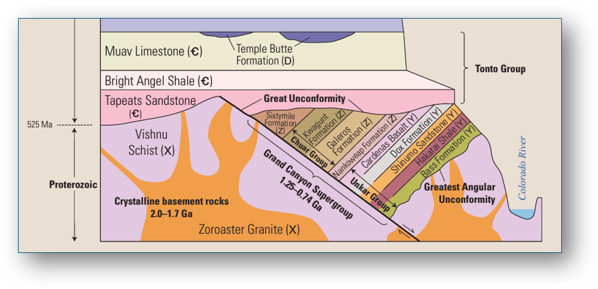
Figure 3. Stratigraphic relationships in the Grand Canyon showing the Tonto Group, including the Sixtymile Formation. As Snelling noted, Karlstrom et al. (2018 ) has moved this formation into the Cambrian Period. The stratigraphic relationships have not changed. (Billingsley, et al., 2019)
The Sixtymile Formation includes several zones of chert, a sedimentary rock composed of quartz. The surrounding rocks and internal characteristics of these chert beds lead geologists to interpret them to have formed originally in fresh water lakes (Donald Parker Elston 1979). Oxygen and hydrogen isotope data suggest paleoclimate temperatures that ranged from 27 to 33°C (Kenny 2017). Both Elston and Kenny report the presence of thin brecciated zones of the chert (see Kenny 2017, Fig. 4). Elston’s description of the upper member of the Sixtymile Formation includes this:
“The sandstone is present southwest of the axis of the syncline (fig. 5), is pale red to brown, and contains scattered rock fragments that include chalky-white chert derived from the middle member” (Elston 1979, p.12)
What does this say about how long it took to deposit the unit? It shows silica-enriched fluids moved through the sediments and formed this chert over long period of time. It was then hardened before being broken up into rock fragments. Soft sediments don’t break up like those shown by Kenny 2017, Fig. 4. Yet this brecciation took place as sediments were being laid down, not by shattering along a fault, such as a fault breccia. This demonstrates a significant pause in the deposition between the original deposition of the cherts and the brecciation. This is problematic for flood geology, given that the entire Sixtymile Formation was deposited in at most a few days in the most popular flood geology models. It is interesting that Dr. Steven Austin (1994), in his book, “Grand Canyon: Monument to Catastrophe” refers to rock fragments in the Sixtymile Formation coming from the underlying Kwagunt Formation, Precambrian in age, but did not mention the chert and other fragments found in the Sixtymile Formation. Dr. Tim Clarey (2018) doesn’t mention chert at all. Perhaps these authors recognized that cherts and depositional chert breccias really don’t support flood geology proposals.
Fossils
A further example of what we would expect that has not been found is Mesozoic or Cenozoic fossils, animals or plants in the Cambrian Tonto Group. We gave examples of a dolphin bone (or any other modern megafauna) or even plant pollen. Dr. Snelling replied,
“However, Flood geologists have repeatedly explained over decades that this pattern of fossils represents the burial order of the global Flood cataclysm.” (Snelling 2026b) (emphasis in the original)
It is true that flood geology has come up with three basic hypotheses. (Roth 1998; Snelling 2010; Clarey 2020). Saying the same thing more times doesn’t make it more true. Perhaps Dr. Tim Clarey said it best here:
“The global pattern of fossils cannot be denied. Why certain animals and plants are only found in certain rock layers is still largely unresolved. Creation scientists have often speculated and proposed various ideas to try and explain the patterns we observe in the fossil record.” (Clarey 2020)
Although terminology can vary, these explanations revolve around the same three speculations:
- The motility factor (Roth 1998); Increasing mobility (Snelling 2010)
- The buoyancy factor (Roth 1998); Decreasing density and other hydrodynamic factors (Snelling 2010)
- The ecological zonation theory (Roth 1998); Increasing elevation of habitat (Snelling 2010)
Each speculation could have some validity in local areas. One problem is that none of these would work globally or even in large basins. First, consider the motility factor, where more mobile animals were able to avoid the flood longer. This means that while retreating from advancing seas with massive earthquakes, tsunamis and hurricanes, every reptile, dinosaur, and mammal was able to move to higher ground. None were injured and swept out to be deposited. This sounds ad hoc.
Also, the idea of mobile animals trying to outrun flood waters takes advantage of the difficulty many people have in thinking three dimensionally. Once a region of any size was covered over with initial Flood sediments, everything else would have to be swept in laterally by hyper-fast, continent-scale sediment flows. Thus, after initial Flood sediments were laid down, any animal’s ability to move from one place to another would be irrelevant – they could only just be “along for the ride” with transported sediment.
How about the buoyancy factor? It is really hard to buy that buoyancy separated the fish away from the Tonto and all of the other early Paleozoic sections or that it had any part in separating early reptiles and dinosaurs from mammals. Dr. Snelling pointed out that fish have been found in Ordovician rock (Snelling 2026b), but those fish were really different from those of today. Arandaspida (Figure 4), an early jawless fish hardly counts as finding a modern animal in ancient sediment. But it does prove that swimming animals were preserved in early Ordovician sediments. This makes it all the more difficult to understand why there are no examples found anywhere in the world of any more modern fish in earlier Paleozoic rocks or any examples of swimming mammals in any Paleozoic rocks.
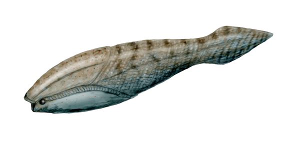
Figure 4. Arandaspida, early toothless fish (By Nobu Tamura (http://spinops.blogspot.com) - Own work, CC BY-SA 3.0, https://commons.wikimedia.org/w/index.php?curid=19460450}
Regarding the various elevation zonation theories, again this seems plausible in local settings. However, Roth (1998) observed,
“The major problems facing the theory all relate to the extreme sorting of many organisms as found in the layers of the fossil record. Current ecological distributions only rarely reflect this. We might explain some of this sorting by extensive lateral transport of organisms from limited source areas during the flood, but the problem seems more general and is not limited to single source areas.”
Roth’s observation captures the earlier described lateral transport problem that flood geologists such as Dr. Snelling set aside. This ecological zonation explanation seems to contribute little to explaining the global distribution of fossils.
Other fossil types just do not really fit any of the three hypotheses given, even locally. Such fossils include sessile (bottom attached) fauna and many types of microfossils. Sessile forms found in situ, buried where they lived and found throughout the stratigraphic column are highly problematic for flood geology. Another example is the progression of microfossils found that are used so successfully in the oil industry to determine the stratigraphic age of sediments. I (Stephen) have further discussed the issue posed by the microfossils in rocks here: The Microfossil Record.
Dr. Snelling noted the presence of microfossils in the Tonto Group. It is interesting that the Bright Angel Shale does contain fossils known as cryptospores. Baldwin, et al. (2004) studied the cryptospores in detail through the Bright Angel formation and concluded that there was a definite freshwater source for the muds. They observed:
“Initial correspondence between organic matter content in mudstones and feeding type and intensity (as indicated by traces) is consistent with an estuarine setting for this deposit. The level of organic activity preserved in these sediments indicates that the carbon flux into shallow marine settings due to terrestrial runoff was substantial by Middle Cambrian (Glossopleura biozone) time.”
One key significance of the cryptospores is that microfossils were preserved, making the absence of more modern microfossils all the more striking.
What about the preservation of fossils? Dr. Snelling wrote:
“However, Mitchell and Tillman do not grapple here with the proverbial “elephant in the room.” After all, how these creatures were fossilized tells us how quickly they were buried and thus how fast these sedimentary layers were deposited. They never explain how fossils form! In their uniformitarian belief system, creatures are slowly and gradually buried by sediments. But do we see fossils forming today under such conditions? Resoundingly no! Unless creatures are buried rapidly under a lot of sediment, they either move away from danger, rot after death, or are eaten by scavengers. Furthermore, unless animal tracks and traces are rapidly buried and preserved, they are obliterated by the very tidal conditions Mitchell and Tillman maintain were responsible for deposition of the Tonto Group as proposed by their fellow uniformitarians.” (Snelling 2026b)
Simply put, we do not believe there is an elephant in the room. Fossils are preserved in many ways. The scientific study of the processes by which fossils are preserved is called taphonomy. Many taphonomic processes involve rapid deposition. The fact that many fossils were preserved by rapid events in no way proves that they were all formed by the same rapid event. If the Phanerozoic period lasted over 500 million years, then we can safely assume that many, many floods, storms and catastrophes occurred that could preserve fossils.
Things found that we would not expect to find
Normal marine, fluvial and other paralic (non-marine) deposits
Field work and descriptive geology continues today, in part because of the number of classic exposures found in Arizona. Yet, no one reports the type of chaotic, high velocity deposits that one would expect from a global cataclysmic flood. What do recent studies report? In November of 2024, Dr Carol Dehler et al. (2024) published a refined stratigraphic model for the Cambrian of the Grand Canyon. Their refinement was based on more measured sections and extensive biostratigraphic analysis. Building on the work of previous investigators, they describe the environments this way:
“Rather than being fully marine in origin, these sequences were formed by a mosaic of depositional environments including braided coastal plain, eolian, marginal marine, and various shallow marine environments.” (Dehler et al. 2024)
They present a series of generalized paleogeographic maps for eight different portions of the Cambrian system in the Grand Canyon area. Environments range from fluvial and shallow marine in the Tapeats Sandstone to marine with local carbonate banks higher up in the Muav Formation. These are interpretations, but they are consistent with all of the observations. They also are consistent with the limited observations that we (Steve) have made more recently. (See plates at the end). We continue to see evidence that sedimentation was not continuous but had many pauses of various durations.
Dr. Snelling believes that the features that he has observed are consistent with tsunamis, but what we see are many small channels, particularly like those from settings without vegetation. (See Plates IV to XII, particularly Plate XII.) A recent study of the Tapeats Sandstone highlights this relationship (Myrow et al. 2025). They compare channels exposed in the Tapeats Sandstone outcrops around Payson, Arizona to characteristics of fluvial systems elsewhere. They find that the systems in the Tapeats shared characteristics with other low-sinuosity river systems, particularly those in areas without vegetation that would have increased tendencies toward meandering styles. The facies suggest “low sinuosity meandering rivers in a sandy floodplain”, with well-preserved point-bar packages. Interestingly, they report that in their study area, the Tapeats includes ~7.5% to 13% shale, considerably more than in sections measured along the Grand Canyon. At one location, they report “cobble to boulder conglomerate that rests inside bedrock incised valleys that are several meters deep and include clasts up to 28 × 15 × 18 cm in size”. This is entirely consistent with preserved stream channels where the Tapeats onlapped basement. This fits well with the interpretation from Dehler, et al., 2024 of the lower Tapeats transitioning from a braided plain/delta in the east to more open marine conditions in the west. Increasing storm deposition in the units moving up the section is also predictable. These types of mappable facies systems would be physically impossible to form under a sedimentation regime that deposited on the order of 100 vertical feet per day over the continents.
Sedimentary structures
Dr. Snelling doubled down on his interpretations of the features that we presented as inconsistent with flood geology. Again, every hill is a hill to die on for flood geology. Here we will look at his positions again for herringbone cross-stratification, mudcracks, and fossils, such as the stromatolites and trace fossils.
Herringbone Cross-Stratification
One surprising thing to find is strong evidence of tidal deposits that reflect normal tidal ranges. We noted that six different investigations reported a specific type of cross-stratification with alternating ‘V’ shaped bedding, known as 'herringbone cross-stratification’ in the Tonto Group and it is also found in other Cambrian formations in the southwestern U.S. The reversal of the bedding demonstrates a reversal of fluid flow in a relatively short time frame. We know that this type of bedding forms today in some tidal settings. Finding these delicate, cyclical tidal signatures through the Tonto Group is a clear indicator of daily, rhythmic tides operating over vast stretches of time, which directly contradicts the chaotic, unidirectional flow expected from a global mega-tsunami.
Dr. Snelling wrote, “Herringbone cross-stratification (Fig. 5J) has been reported in all of the Tonto Group formations, although it is not as common as Mitchell and Tilman claim (Figs. 5 and 6).” (Snelling 2026b) This is not actually accurate as we never addressed the amount of herringbone cross-stratification. We did note six articles that referred to its existence in the Tonto units (Hereford 1977; Fedo and Prave 1991; Middleton, L.T. and Elliott, D.K. 1990; Baldwin et al. 2004; Rose 2006; Snelling 2022). Where we differ is in the explanation and significance of these beds.
Dr. Snelling proposes that such sedimentary structures can be formed during hurricanes and tsunamis but provided no support for this beyond the fact that formations that he interprets as resulting from Noah’s flood contain such features. Hypothetically one could have enhanced tides during prolonged storms, but none seem to have been reported in the literature, though perhaps a more extensive study might identify such.[1] It does seem clear that such stratification would be rare.
Dr. Snelling included in his Figure 7, two illustrations of water motion as waves approach the shore (Snelling 2026b). Motion from hurricanes and tsunamis would largely be the same. It is not clear what he thinks these prove. Water motion for all waves works this way. Such waves do not form herringbone cross-stratification and there is no reason to suggest that larger waves would do differently.
Neither we, nor Dr. Snelling have produced photographs showing examples of herringbone cross-stratification from the Tonto Group. We can however show a photographic example from what he would consider an equivalent unit, based on Snelling’s Figure 1 (2025), though it is better dated to Early Ordovician in age. Here in the Bliss Sandstone, we see preserved at least portions of 16 cycles, representing deposition over a minimum of 4 days (Figure 5). Remember that this is a tiny portion of the Bliss Sandstone (Bentley 2014). Other examples of tidal deposition in units that would be flood deposits in flood geologic models are found here: here: Tidal Clocks and Flood Geology. In one case, daily and monthly tidal bundles have been documented representing six years of continuous deposition. Certainly, flood geologists would try to come up with other explanations, but would they be valid?
[1] How about in the interpretation of ancient rocks? Two articles were found that described herringbone cross-stratification that also discussed storm deposits, but the herringbone cross-stratified beds were not part of the beds that are really comprised of storm deposits. (Varela et al. 2011; Leckie and Walker 1982)
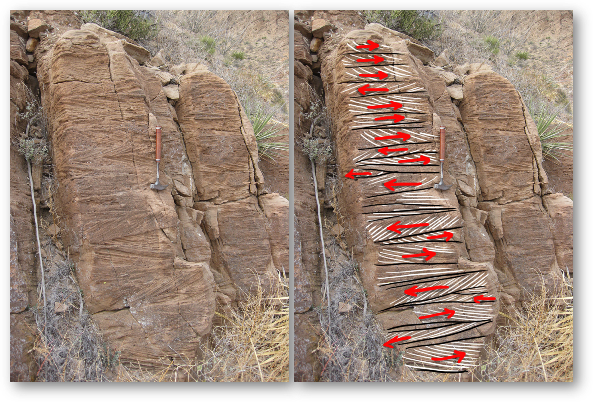
Figure 5: Herringbone cross-stratification from the Bliss Sandstone, Franklin Mountains, El Paso, TX. Used with permission of Callen Bentley (Bentley, 2014)
Other Sedimentary Structures.
Hummocky cross-stratification (HCS), typically considered indicative of storm deposition, is reported by many in the Tonto Group. Snelling quite rightly notes that in our published version, we inadvertently failed to include the bibliographical information for the modern tidal flats of South Korea (Yang et al. 2006). Here we correct this:
Yang, Byongcheon, Robert W. Dalrymple, and Seungsoo Chun. 2006. “The Significance of Hummocky Cross-Stratification (HCS) Wavelengths: Evidence from an Open-Coast Tidal Flat, South Korea.” Journal of Sedimentary Research 76 (1): 2–8. https://doi.org/10.2110/jsr.2006.01.
This reference is significant in this context, because it shows that one cannot rule out either tidal or proximal shallow marine settings for the Tonto based on the identification of hummocky cross-stratification. We have not claimed that any of the depositional models is totally correct but that features such as the herringbone cross-stratification are not consistent with the flow and depositional rates proposed by Snelling. Many characteristics of the Tonto Group are consistent with tidal settings with braided or low sinuosity stream input. Dr. Snelling complains that we did not, in our short paper, address other sedimentary structures. We simply chose to address those that we feel are diagnostic and inconsistent with flood geologic rates and processes. All of the sedimentary structures he has reported fit easily into deep-time understandings but some don’t fit with flood geology.
Mudcracks
In our article, we included a discussion of features from the Tonto Group interpreted by several investigators to have resulted from desiccation, as sediments dried out. These features, called “mudcracks” provide a real challenge to flood geology.
Dr. Snelling recognized the issue that these features raise in this quote:
“Today these polygonal features are indicators of at least some time of exposure and drying of sediment surfaces. Thus, such features in the Tonto Group layers, if validly interpreted, would be difficult to reconcile with either the rapid rate of sedimentation or the limited time available during the biblical, yearlong, global Flood cataclysm because their formation demonstrates periods when deposition stopped.” (Snelling 2026b) Emphasis added
Dr. John Witmore put it this way:
“It is unlikely that true desiccation cracks would have formed at the height of Noah's Flood because of the time needed to expose, desiccate, and crack the sediments. It is even more difficult to imagine forming multiple layers of desiccation cracks during the Flood.” (Whitmore 2009)
This is another hill to die on. Flood geologists really cannot bend too much on this, given that the number of apparent beds with these polygonal features surely numbers in the thousands, often with multiple levels in the same section.
In the following quote, Whitmore indicates that mudcracks can form quickly and as such could be found in flood intervals:
“Also (surprisingly), rapid desiccation mud crack development has been documented during humid, rainy conditions and on modern shorelines during very brief intertidal exposure. Even though they are probably rarer in the rock record than Flood critics admit, it also appears that true mud cracks could have formed during the Flood.” (Whitmore 2009)
The articles he cited don’t seem particularly relevant to Noah’s flood. He cites a 1935 article by Paul Dimitri Krynine who reported mud cracks that developed over a brief time during a rainy season in Connecticut (Krynine 1935). Though they were preserved through several rains, they certainly are minor features compared to most reported ancient examples. The scale and depth do not compare. He also cites Jean-Claude Dionne’s report of mudcracks that developed relatively quickly in tidal deposits in Canada.
“Mud cracks and polygons form during summer in tidal flats of the south shore of the St. Lawrence Estuary. They occur near mean low water level at the top surface of ice push mud ridges formed during winter and break-up. They are a source of mud clasts which settle in the surroundings when carried away by waves and currents.” (Dionne 1974)
It is not clear exactly how long it took for these reported mudcracks to develop but they seem to have at least lasted through the summer. These again seem to be relatively irrelevant to global flood hypotheses. The first quotes in this section from Snelling and Whitmore are accurate. For flood geology to be plausible, virtually all of the mudcracks reported in the rock record need to be explained to be something besides desiccation features.
Regarding the examples that we gave, Dr. Snelling wrote:
“I have argued strongly already that “these cannot possibly be ‘mud’ cracks because these features are in a clay-poor sandstone, not mud. And as seen in [Hill and Moshier’s] photograph[s] [their figures on pages 66 and 67 and Mitchell and Tillman’s photograph (their Fig. 5)] of modern mud cracks, when the mud dries the polygonal shapes become concavely arched, whereas the claimed fossilized ‘mud cracks’ are flat.” (Snelling 2026b)
Two points should be clarified. First, the modern example that we showed (Mitchell and Tillman 2024c) was deeply dried but did not show any significant concave arching, though perhaps precise testing would pick up some minor degree of this, but this would be equally possible for the Tapeats example in his Figure 4. Second, the clay content of the sandstone shown in our Figure 5 has not been demonstrated. Dr. Snelling sampled a limited set of beds in his study, and it remains unproven that his characteristics can be extrapolated throughout the Tapeats section, especially as we have agreed that some shale beds are found in the formation. As shown earlier, Myrow et al. (2025) reported increased shale content in their area and Hill (2016) did not identify where their photo was taken.
Dr. Snelling rejects mudcracks in the Muav Limestone, because they would not fit his hypotheses, though mudcracks in tidal settings in carbonates are common, both in modern and ancient sections. Robert B. Halley (1975) published a photograph of Cambrian-aged mudcracks in cross-sectional view from the Carrera Formation in California. In his Figure 32-8, he shows “vertical traces of upturned edges of polygonal mud cracks in dolomitic limestone”. He interprets this portion of the Carrera Formation as ancient tidal sediments based on multiple criteria. The interpretation of the features as resulting from multiple phases of desiccation is very reasonable and hard to place as part of a cataclysmic flood deposit.
Are there criteria that we find in other ancient features interpreted as mudcracks that give reason to believe that they are valid? Dr. Steven Austin provided one such criteria. He provided sketches of two scenarios for cracks that resulted from the shrinkage of sediments, in this case, from the Permian aged Hermit Formation in the Grand Canyon. In the caption from the figure, he wrote:
“Figure 3.17 Shrinkage cracks are shown in block diagrams, where sandy or silty laminae or beds have been injected into cracks in clay-rich layers.
1. Shrinkage cracks seen in the Hermit Formation have both downward and upward penetration, and document the syneresis process, not shrinkage caused by drying.
2. Shrinkage cracks with only downward penetration would be expected to form in Hermit Formation if the clay-rich strata were subjected to drying before the overlying sandy or silty stratum was deposited. Such cracks are doubtful in the Hermit Formation.” (Austin 1994)
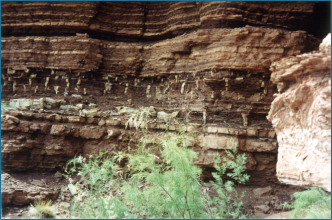
We do not question that syneresis or diastasis cracks could be present through the rock record. It is also true that in most cases, we do not have the ability to see the bedding both above and below polygonal fractures as only one surface is revealed (Figure 6). Usually, we recognize polygonal fractures while observing them on the top or base of a bed, but there are exceptions. One example, where the image is in the public domain. is shown in Figure 7. These are clearly multiple layers of actual mudcracks.
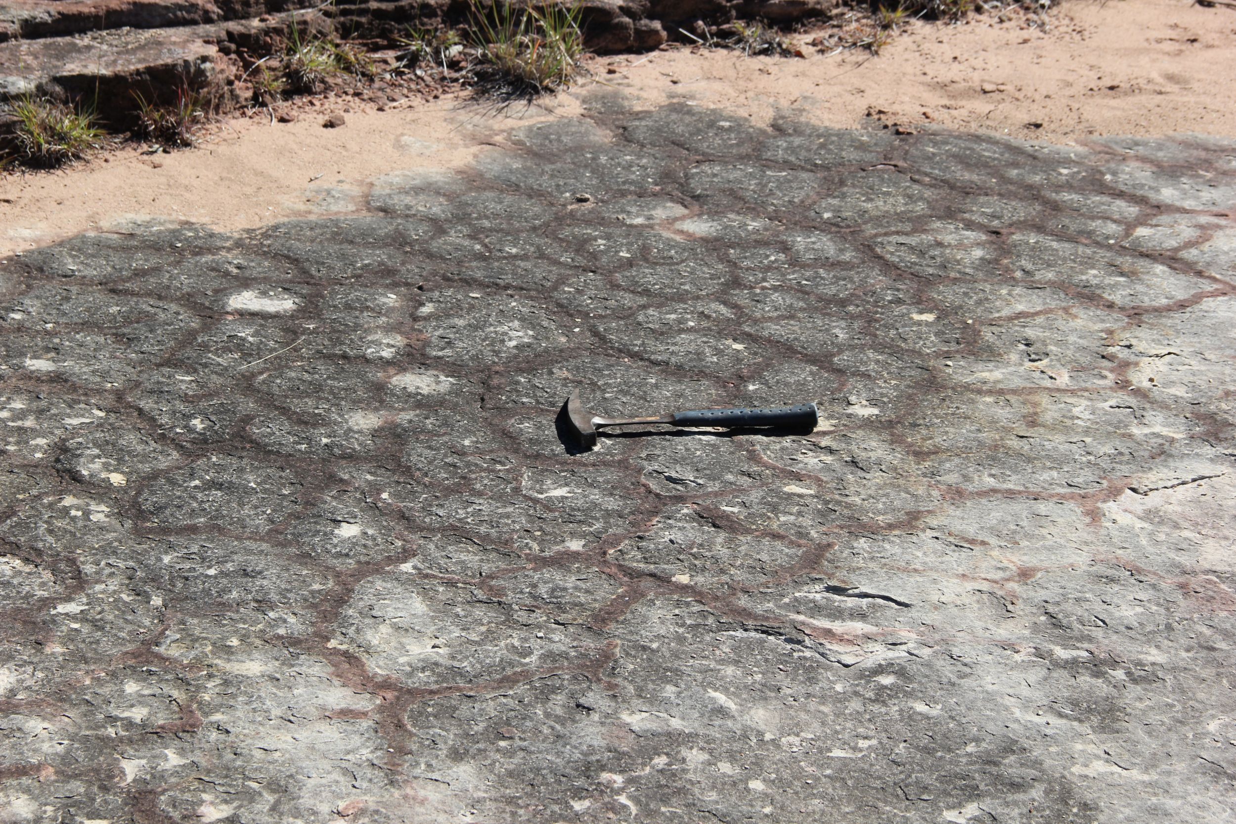
Figure 6 Mud cracks from Cambrian Hickory Sandstone in Central Texas (Nielson and Barker 2013)
Figure 7. Multiple layers of mudcracks in cross-section view, Moenkopi Formation, Red Canyon, Glen Canyon National Recreation Area. At least 5 levels are visible. Notice that each thin downward from a surface. Photo from the National Park Service.
Plummer and Gostin (1981) named the presence of vertebrate tracks as one criteria for recognizing subaerial mudcracks. Dr. Snelling proposed that such tracks would fit in flood models.
“Supposed Cambrian mud cracks have been found with fossilized trilobite tracks, and Mesozoic rocks include dinosaur tracks on or associated with supposed mud cracks in many places around the world.” (Snelling 2026b)
Snelling provided this explanation for animal tracks preserved in what he considers flood deposits:
"However, Flood geologists have repeatedly explained over decades that this pattern of fossils represents the burial order of the global Flood cataclysm. Initially, bottom-dwelling shallow marine creatures were buried as the fountains of the great deep (ocean) opened up and tsunamis surged across the shallow ocean floor toward land. Only as the floodwaters eventually surged onto the land were land creatures then buried with marine creatures, although lowland land creatures (amphibians and reptiles such as dinosaurs) were buried before upland land creatures (other reptiles and mammals) were buried as the waters rose to their peak." (Snelling 2026) (Emphasis in original)
While we are unconvinced by this explanation for tracks in general, such as dinosaur tracks, it is not clear to us what this has to do with whether or not the polygonal features were subaerial desiccation cracks, which was the issue under discussion. Figure 8 (Arizona Geological Survey 2021) shows an example from Arizona of mudcracks on a surface that is dominantly sandstone. Dinosaur tracks associated with units with interpreted mudcracks are common around the world, often directly on the same beds, as in Figure 9. In many cases, such desiccation features are identified on multiple levels. Dinosaur tracks associated with mudcracks are in Mesozoic sediments that most if not all flood geologists propose were deposited during Noah’s flood. It is most reasonable to assume that the polygonal features were actual desiccation cracks, formed before the dinosaurs walked on them.
It remains true that we don’t have additional photographic evidence and haven’t conducted a personal examination of beds interpreted as mudcracks in the Tonto Group, including the one we showed in our article. Nevertheless, we consider the interpretation of subaerial mudcracks in these units quite reasonable.
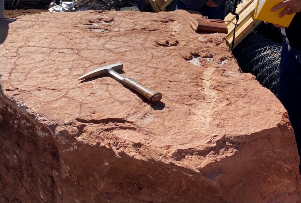 Figure 8. Dinosaur tracks and mudcracks in the Moenkopi Formation, which is estimated to be early to middle Triassic in age (252 to 235 million years ago). This formation is younger than the Tonto units, but they serve to demonstrate that ancient mudcracks developed by exposure in the rock record just as they do today. (Arizona Geological Survey 2021)
Figure 9. Map showing locations of published accounts of dinosaur tracks associated with mudcracks.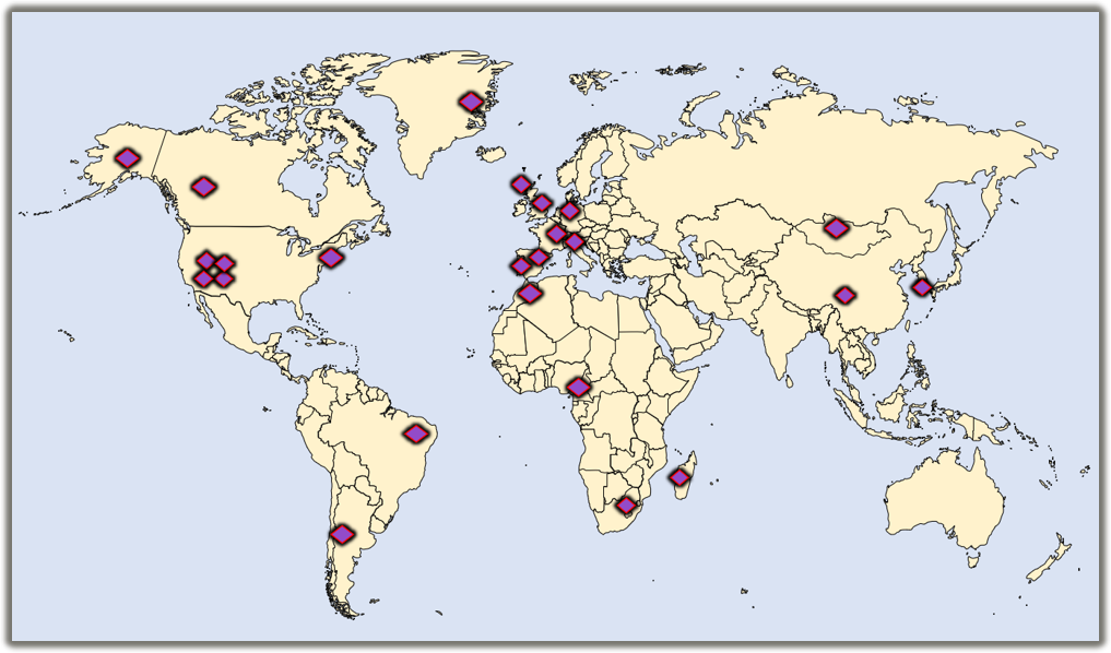
Trace fossils (Ichnology)
Why would we find horizons covered by the tracks and burrows of various animals if the formations were being deposited at rates of meters per day? In our article, we considered trace fossils to be inconsistent with flood geology. We wrote, “These were not some sort of death assemblage, transported into place, where a few survivors dug around before finally succumbing to the pressure of burial.” (Mitchell and Tillman 2024c). Dr. Snelling, who says that we are not familiar with flood geology literature, wrote this:
“No Flood geologist has argued that these were “some sort of death assemblage, transported into place, where a few survivors dug around before finally succumbing to the pressure of burial,” (Snelling 2026b)
While our statement may have been a paraphrase of flood geology positions, this is essentially what flood geologist John Woodmorappe described in his article, “Are soft-sediment trace fossils (ichnofossils) a time problem for the Flood?” (Woodmorappe 2006). Here are quotes:
“Furthermore, large and complex individual ichnofossils, including common ones such as Cruziana and less common but metre-sized ones visually reminiscent of washboard, can all form within strata.” p. 115
“One notable exception is the study of ‘doomed pioneers’. According to this concept, it is believed that organisms washed downslope onto an inhospitable seafloor surface can sometimes burrow for a short time before they die. Of especial relevance to Flood geology is the fact that numerous types of marine life are known to be capable of surviving transport, after which many of them will commence burrowing when deposited on or within a layer of sediment.” p. 116
Although Snelling might describe it differently, something like this is also what he must rely on. What alternative does he have? There certainly would have been no time in his timeline for new generations of animals to grow to maturity, to later burrow or make other kinds of trace fossils. Burrows like we showed in our Figure 7 (Mitchell and Tillman 2024c) and Snelling showed in his Figure 10 (Snelling 2026b) don’t appear overnight. They imply pauses in sedimentation for days, days flood geology models just don’t allow for. They also imply an endless supply of burrowing animals – far too many for the planet to support all at once -- an issue which flood geologists ignore.
The example in Figure 10 show trace fossils in a relatively sandy portion of the Bright Angel Formation (Santucci and Tweet 2020). Teichichnus trace fossils were made by animals that fed by burrowing along the water bottom (Baldwin et al. 2004). Notice that there are at least three surfaces along which these animals burrowed. The simplest explanation is that each of these was the water bottom for some period of time.
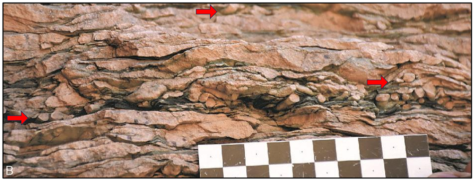
Figure 10. Trace fossil, Teichichnus from the Bright Angel Formation. Red arrows highlight different horizons where the trace fossils are preserved. (Santucci and Tweet 2020)
The example in Figure 10 show trace fossils in a relatively sandy portion of the Bright Angel Formation (Santucci and Tweet 2020). Teichichnus trace fossils were made by animals that fed by burrowing along the water bottom (Baldwin et al. 2004). Notice that there are at least three surfaces along which these animals burrowed. The simplest explanation is that each of these was the water bottom for some period of time.
Time equivalent sediments in the Death Valley in the Great Basin in California provide more evidence that sedimentation paused repeatedly. Mata, et al. (2012) documented clear examples of trace fossils left by animals that lived like modern burrowing anemone. They wrote, “The lower Cambrian upper member of the Wood Canyon Formation in the Death Valley region, United States, preserves large vertical burrows up to 30 cm in length and 7 cm in diameter within oolitic and sandy dolostone and dolomitic sandstone beds” citing work by Corsetti and Hagdorn (2000). Think about this. Modern burrowing anemone live in a self-constructed wrinkled felt-like tube which was buried down in sand. When these Cambrian layers formed, ancient animals did just the same. All characteristics described in this formation are consistent with tidal deposition, including other sedimentary structures, such as herringbone cross-stratification. The burrows and other features are again inconsistent with a flood interpretation for the Cambrian section.
How could all of these trace fossils have been buried to be preserved? Do trace fossils make sense in deep time scenarios? Normal sedimentation processes, including storm and turbidity currents have covered tracks even in modern times. Vast numbers of such events would be expected to have occurred over millions of years. If it were a problem to preserve trace fossils with normal sedimentation processes as Dr. Snelling suggests, then we would expect very few trace fossils in units that he interprets as post-flood. That clearly is not the case. Trace fossils from mammal tracks to earthworm burrows (Verde et al. 2007; D’alessandro and Bromley 1986; Williamson and Lucas 1996) are common in Pleistocene sediments and other intervals that Snelling interprets as post-flood. Obviously, a global flood is not required for trace fossils to be preserved.
Carbonates
Regardless of the duration, pauses in sedimentation are indicated by beds covered with trace fossils. What kind of time duration is indicated by the other kinds of layers in the Tonto Group? Dr. Snelling correctly pointed out that some mud-sized material and some carbonate muds can be deposited relatively quickly. For flood geology to be a viable hypothesis, this must be true for every one of the shales and limestones through the intervals interpreted as flood deposits.
Snelling wrote:
“However, it has been amply demonstrated by Flood geologists that ancient limestones are distinctly different from today’s lime deposits that uniformitarians claim are their analogues.” (Snelling 2026b)
He is correct in the sense that modern carbonate muds are dominantly of a different form of calcium carbonate than ancient limestones. Modern carbonate muds are dominantly composed of aragonite, while ancient limestones are dominantly calcite. Aragonite and calcite have the same chemical composition, but are stable over different temperature and pressure ranges. Geologists recognize that lime muds and fossils were typically originally deposited as aragonite but transformed by diagenesis to calcite. Relict aragonite structures have been observed in calcite dominated limestone (Lasemi and Sandberg 1984). Certainly not all of the details about how this occurred are understood, particularly given the variety of settings involved, but that it often occurred is not in doubt (Munnecke et al. 2023). In some cases, evidence suggests, for instance, that ancient ooids could have formed as calcite ooids instead of aragonite ooids because the chemistry of the ancient seas was different (Sandberg 1975).[1] We cannot assume that the past was exactly like the present. Diagenetic changes are ubiquitous in the rock record however. In many cases, the aragonite was transformed further into dolomite. It is actually difficult to identify any scenarios whereby aragonite-dominated beds could be preserved as such, after even only shallow burial. It is also unlikely there were scenarios where regional carbonate diagenetic transformations could have occurred in the brief period proposed by flood geology.
Dr. Snelling declared,
“They are also totally ignoring God’s Word that describes the “fountains of the great deep” breaking up and remaining open for 150 days (Genesis 7:11, 24 and 8:2–3). As already explained by Flood geologists but ignored by Mitchell and Tillman, these superheated waters fountaining upward from the earth’s mantle most likely were supersaturated with lime, silica, and various salts derived from breaking down mantle and crustal rocks at depth and during their upward passage. When that superheated steam mixed with the cold ocean waters, the sudden drop in temperature would drastically change the supersaturation conditions so that the contained salts were precipitated rapidly and even transported by the surging humungous tsunamis generated by the devastating earthquakes due to the catastrophic plate movements.” (Snelling 2026b)
This is just an unsupported creative hypothesis based on an interpretation of Genesis that goes far beyond what the text actually says.
[1] Ooids are round grains of sand that formed as minerals precipitated around a nucleus that rolled around, agitated by waves or shallow water currents, usually in warm water. Today they are dominantly calcium carbonate, but in the Cambrian, glauconite and hematite ooids also formed. In the laboratory, calcium carbonate in the form of aragonite forms them over weeks (Davies et al. 1978). They are found in thousands of beds in the rock record. How could they have formed during a flood?
Algal Mats (Stromatolites) and other reef deposits
Reefs are common features of ancient sediments and modern marine shelves. We find them in every time period from the Proterozoic to the present. The cast of characters changed through time, but the features are recognizable and provide challenges for any flood interpretation.[1] In our opinion, no other single characteristic of the rock record is easier to document and more difficult to reconcile with flood geology processes and timelines. In these discussions, we focus on Cambrian examples.
Given the different ways the term reef has been used, it is worth documenting what we mean by “reef”. Here is the definition that Steve published (Mitchell 2018) specifically for distinguishing features that impact flood geologic interpretations.
- A reef represents a concentrated organic accumulation: Many ancient and modern lifeforms, both animals and plants, have left accumulations of lime skeletons. Examples here include algae, corals, rudists, and other ancient animals.
- A reef is a build-up or mound: Reef will be used for accumulations that had positive bathymetric relief. Other organic lime accumulations also took long times to form but would not here be referred to as reefs.
- A reef is locally derived and includes some preserved lifeforms that grew in place: Modern coral reef deposits include some coral that grew in place, but much is broken and much ends up having been eaten by various animals. Even so, the reefs considered here all have some species that are found in their growth position.
- A reef has associated facies are consistent with modern reef settings: In each of the cases that we describe as reefs, internal facies of the reefs have been mapped in as much detail as the deposits will allow and they are consistent with modern reefs and the facies that surround modern reefs.
Features that meet these criteria all developed over time durations that significantly extended beyond the one-year long period hypothesized for a global flood. In Cambrian rocks, two main types of deposits are characterized as reefs: archaeocyatha and stromatolites. Archaeocyatha were a type of calcareous sponge that attached to the water bottom and grew together to form ancient reefs (S. Pruss, n.d.; S. B. Pruss et al. 2019, 2021). (Figure 11) They appeared and disappeared in the Cambrian period. Most of the archaeocyatha reefs that have been identified are relatively small, but still reflect growth over a period of years. The general location of key published archaeocyatha reefs in southern Nevada is shown on Figure 12 (Figure 8 in Mitchell and Tillman 2024c). Notice that they were not far from the Grand Canyon. Such reefs did not exist in flood geology models.
[1] Further discussions of the issues that reefs pose for flood geology are here: Ancient Reefs confirm Deep Time and sink Flood Geology and Issue #1: Ancient and Modern Reefs
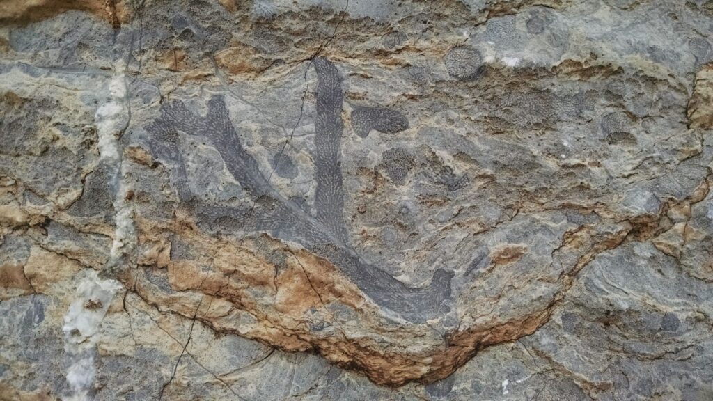
Figure 11. Branching form of archaeocyath from Rowland's Reef in Nevada. Image from Wikipedia: Killamator, CC BY-SA 4.0 <https://creativecommons.org/licenses/by-sa/4.0>, via Wikimedia Commons
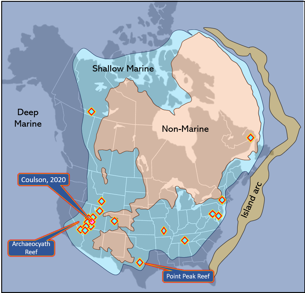
Figure 12. Simplified Late Cambrian paleogeography from Blakely’s “Key Time Slices of North America”(2013), with locations of “apparent in-situ” stromatolitic reefs from Coulson (2021). Notice that the occurrences fall within shallow marine regions on the map. The recognition of in-situ stromatolites that developed after the GU is not reconcilable with most FG models and this issue appears repeatedly in the Cambrian record. In addition, the figure locates another form of Cambrian reefs from an ancient sponge, archaeocyaths. This also would not fit FG models.
The earliest and most prominent reefs in the Cambrian period were stromatolite reefs. Stromatolites represent stacked layers of biogenic deposits and are a particular form of features known as microbialites or microbially induced sedimentary structures (MISS). The following is a good description of these features.
"Benthic microorganisms form highly organized communities called “biofilms.” A biofilm consists of the individual cells plus their extracellular polymeric substances (EPS). In marine and non-marine environments, benthic microbial communities interact with the physical sediment dynamics and other factors in the environment in order to survive. This interaction can produce distinctive sedimentary structures called microbialites. Binding, biostabilization, baffling, and trapping of sediment particles by microorganisms result in the formation of microbially induced sedimentary structures (MISS); however, if carbonate precipitation occurs in EPS, and these processes happen in a repetitive manner, a multilayered build-up can form—stromatolites." (N. Noffke and Awramik 2013) Emphasis added.
Many such microbial features are noted in Cambrian strata (Nora Noffke and Gass 2026). Such features are found in rocks and sediments from the Archean and Proterozoic eras all the way to recent (Chivas et al. 1990; Vahrenkamp et al. 2024; Macintyre et al. 1996). Stacks of sediment formed by biofilms that trapped sediments and enable their preservation are categorically not part of any cataclysmic flood deposit. Modern laminations have been measured to grow at rates of 1.6 to 5.6 years per lamination (Petryshyn 2013). Figure 10 showed many places where Cambrian stromatolitic reefs have been recognized. Figure 13 is one example from central Texas where many small patch reefs are exposed. (Ahr 1971; Chafetz 1973; Nielson and Barker 2016; Khanna et al. 2020, 2020).
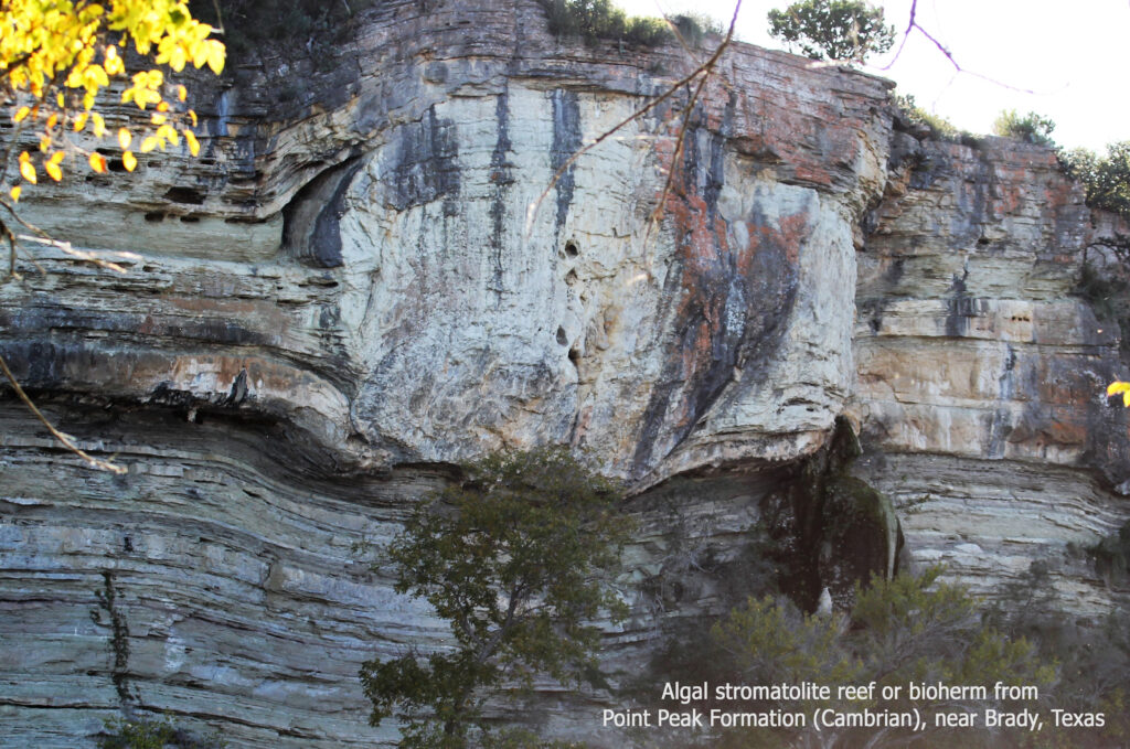
Figure 13. One of a set of algal stromatolite reefs or bioherms from Point Peak Formation (Cambrian) in central Texas (Ahr 1971; Chafetz 1973; Nielson and Barker 2016; Khanna et al. 2020; Hopson et al. 2025).
Stromatolites in the Muav Formation in the Grand Canyon area have been reported by several investigators, as we pointed out in our article (Resser 1945; Hardy 1986; Korolev 1997; Wanless 1973; Mitchell and Tillman 2024c). Stromatolites are clearly problematic for flood geology and Dr. Snelling fully recognized the issue as he wrote:
“Mitchell and Tillman are correct in asserting that true stromatolites “demonstrate alternate periods of flooding and exposure, typically by tides,” as seen for example in Hamlin Pool in Shark Bay, Western Australia today. And it is true that genuine stromatolites in the Muav Formation would be a challenge for the biblical global Flood cataclysm interpretation.” (Snelling 2026b) Emphasis added.
Thick accumulations of tidal layers just could not have been formed as tiny parts of a one-year cataclysmic flood deposit. The first rescuing proposal is: maybe they aren’t really algal:
“However, microscopic examination of both today’s stromatolites and many of the fossilized stromatolites reveals the algae and fossilized algae are responsible for building the stromatolites. No one has checked under a microscope that these banded units that have been interpreted as stromatolites to confirm whether any fossilized algae are present. So should we doubt the reports of stromatolites in the Muav Formation until this work is done? Absolutely! Until that is done, these banded units cannot be claimed to be stromatolites. Besides, the stromatolites being built by cyanobacteria today are mounds and not banded units built by algal mats.” (Snelling 2026b) Emphasis in original.
Yet as we examine Snelling and his co-author’s statement in a fairly recent paper, he admits that such bacterial structures are likely to be rare in ancient authentic biogenic features:
“Since precipitation and mineralization are not directly associated with bacterial structures (such as cyanobacterial sheaths) it may greatly diminish the number of microfossils associated with fossil stromatolites. Therefore, the absence of microfossils in fossil stromatolites is not necessarily an indicator that abiogenic processes formed them.” (Purdom and Snelling 2020)
Are the examples in the Muav valid biogenic stromatolites? Look at what the paleontologist Charles E. Resser wrote and showed in 1945.
“The small nodules with concentric structures in certain parts of the Muav limestone are considered to be algal deposits, and resemble the type usually referred to as Girvanella. The structure in well preserved specimens is similar to that which is characteristically developed by this plant through the concentric disposition of its tubes.” (Resser 1945)
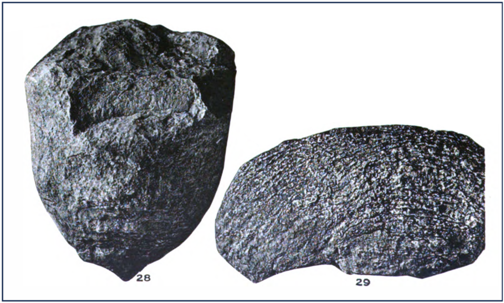 Figure 14. Algal stromatolites called Girvanella from Resser 1945.
Resser showed two examples in his Plate 17 (28 and 29) (Figure 14). These certainly seem to be diagnostic fossils identified by an expert paleontologist. It is unclear what other options would be. Ressner and McKee reported several types of occurrences for these features. (Resser 1945; McKee 1945)
The presence of stromatolites in the Tonto Group was also published recently in the French Mountain Dolostone (Rowland et al. 2023). The Frenchman Mountain overlies the Muav Formation and was added to the Tonto Group by Karlstrom, et al. (2020). (Snelling 2021b). They are recorded in multiple beds in several measured sections.
It is very significant that several workers documented stromatolites in the Upper Cambrian above the Muav. One can’t have early flood deposits in the Tonto, covered by non-flood deposits in the Upper Cambrian and then go back into flood deposits. Some of those documenting such deposits in just the USA include: (Ahr 1971; Palmer and Halley 1954; K. P. Coulson 2021; K. Coulson 2016; Khanna et al. 2020; Retallack 2025). Khanna et al. (2020) and Hopson (2025) are two recent studies that describe the stromatolitic mounds in Mason County, Texas, one example of which was shown in Figure 13. They show that many mounds are preserved and about how they developed.
Dr. Snelling’s suggestion that these features, which grew in such prolific numbers, are not biogenic growth features, reefs as most geologist would recognize them, is showing desperation. No one should dispute that there are stromatolitic reefs in the Cambrian. If flood geologists have to recognize that Cambrian reef deposits exist, is that the end of their story? Dr. Snelling proposed another rescue mechanism, in case the first one didn’t work:
“Flood geologist Coulson certainly has “documented Late Cambrian stromatolitic reefs in the Notch Peak Formation in Utah in great detail.” But those thick intervals of “stromatolitic reefs” that are stratigraphically younger than the Muav Limestone and well above the Great Unconformity may not have grown in place as no geologist observed them growing.” (Snelling 2026b)
Here we go again. No geologist saw them. We have to trust that God has not deceived us. Were all of these rocks transported into place? No one has proposed how this might have taken place or showed any evidence that it occurred. How far could one transport large bodies of rock with stromatolites apparently in growth position?
Young Earth Creationist, Dr. Ken Coulson (2021) explained the issue that stromatolites cause for flood geology here:
“The crux of the issue is not biotic vs abiotic, it is time (Purdom and Snelling 2013). In bed 9, for example, time-dependent processes were responsible for microbialite coalescence and elongation (K. P. Coulson et al. 2016). In bed 11, encrusting sponges constructed 30 – 70 cm-high microbialites one lamination at a time.”
This process does not fit inside a one-year long cataclysmic flood. Coulson recognizes that if a global flood occurred, far less sediments resulted from it than many flood geologists claim. Coulson’s conclusions should be significant to YEC, because he did not start out trying to force these into any old earth model. They are also significant because his thesis advisors were Dr. Leonard Brand of Loma Linda University and Art Chadwick of Southwestern Adventist University, both prominent flood geology authors. Coulson even noted apparent herringbone cross-stratification as further verification that the stromatolites were from an intertidal zone.
Responding to our claim that reefs are found throughout the geologic column and that we find no place to put a flood, Dr. Snelling (2026b) writes “However, in making that claim, they ignored several robust responses to such claims.” We have read each of the articles that he sites and have not found them robust. The claims can be summarized just like those he gave for the Cambrian example. Either they were not a reef or they were transported. References in Steve’s website were cited in a footnote earlier. They require one to start with the assumption that the rocks were formed during Noah’s flood and then try to force the data into this proposition.
Part 2 Conclusions
When we wrote our response to the Snelling papers on the petrology of the Tonto units and their interpretation of the duration over which they were deposited, we knew that these would not be acceptable to Dr. Snelling or other flood geologists. Our claim was that the features in these rocks and other time equivalent units are incompatible with the flood geology timeline and the processes that it demands. Dr. Snelling responded by pointing out that we weren’t there and by claiming that our bias from our geological training and experience makes our points invalid. He rejected the evidence that we presented and this was not surprising for him, given that he will continue to claim that the data in the rock record support the flood geology proposed interpretations. In this portion of our reply, we have expanded our description of some units and the YEC literature we consider pertinent.
We pointed to a number of characteristics that one should expect in a deposit from a global cataclysmic flood deposit where sediment was moving at very, very high rates and depositing at enormous rates. Chaos and mixing of sediment, comminuted grains should dominate most units, but they don’t. The fossil record should be mixed as well, but it is not so. Flood geologist’s explanations could be reasonable to explain local anomalies but are inadequate for the overall pattern.
We also went through his explanations and arguments against the features that we reported as inconsistent with flood geology. Such evidence includes sedimentary structures that classically are seen as indicative of normal sedimentation, such as tidal deposits, including herringbone cross-stratification. It is highly unlikely that we could ever convince him that the mudcracks reported in the Tonto units are desiccation features, but other examples through his flood interval are common and we showed a number that are strongly indicative of subaerial desiccation. Arguments by Snelling (Snelling 2026b) and Austin (Austin 1994) fall flat when they claim that environments interpreted by most carbonate stratigraphers are somehow invalid because the limestones are calcite dominated, rather than aragonite. They fail because such diagenetic changes are well documented in geologic literature and should be expected.
Finally, we came to the stromatolitic reefs. By faith in his model, Dr. Snelling suggests that they must not be stromatolites or if they are, they must have been transported. We showed conclusively that these are algal stromatolites and that even if some were not algal, he still has no option for the layer-by-layer deposition that they record. Moving them as large bodies of rock is not feasible and no mechanism is suggested by Dr. Snelling or any other flood geologist. We continue to be comfortable with the green dots and red dots that we placed in our Table 1.
Acknowledgements
This reply benefited greatly from contributions from Tim Helble and Jeff Reichman, both geologists and Christians. They have helped both in terms of the technical strength of the article and in making it more readable.
References cited:
Ahr, Wayne M. 1971. “Paleoenvironment, Algal Structures, and Fossil Algae in the Upper Cambrian of Central Texas.” Journal of Sedimentary Research 41 (1): 205–16. https://doi.org/10.1306/74D72225-2B21-11D7-8648000102C1865D
Alshakr, Ahmed, Mohamed Sultan, Mustafa Kemal Emil, et al. 2026. “Hyperspectral Fingerprinting of Dune Sediments Across the Arabian Peninsula: Insights Into Sediment Provenance and Transport Pathways From NASA’s EMIT Data.” Geophysical Research Letters 53 (12): e2025GL121122. https://doi.org/10.1029/2025GL121122
Arizona Geological Survey. 2021. “Fossil Trackway, Moenkopi Formation – Flagstaff, Arizona | e-Magazine of the AZ Geological Survey.” Arizona Geology E-Magazine, April 13. https://blog.azgs.arizona.edu/blog/2021-04/fossil-trackway-moenkopi-formation-flagstaff-arizona
Austin, Steven A. 1994. Grand Canyon: Monument to Catastrophe. Institute for Creation Research.
Baldwin, Christopher T., P. K. Strother, J. H. Beck, and Eben Rose. 2004. “Palaeoecology of the Bright Angel Shale in the Eastern Grand Canyon, Arizona, USA, Incorporating Sedimentological, Ichnological and Palynological Data.” Geological Society, London, Special Publications 228 (1): 213–36. https://doi.org/10.1144/GSL.SP.2004.228.01.11
Barnhart, W. R. 2011. “A Hydrodynamic Interpretation of the Tapeats Sandstone Part I: Basal Tapeats.” Creation Research Society Quarterly. https://www.semanticscholar.org/paper/A-Hydrodynamic-Interpretation-of-the-Tapeats-Part-Barnhart/0d4169b9ec04d5440629df2cad59ee3e3c3db874
Barnhart, W. R. 2012. A Hydrodynamic Interpretation of the Tapeats Sandstone Part II: Middle and Upper Tapeats. https://www.semanticscholar.org/paper/A-Hydrodynamic-Interpretation-of-the-Tapeats-Part-Barnhart/7ad0fbc4b9ebba660304c959d0c82bdec2aeca9a
Baumgardner, John. 2018a. “Numerical Modeling of the Large-Scale Erosion, Sediment Transport, and Deposition Processes of the Genesis Flood.” Answers Research Journal 11.
Baumgardner, John. 2018b. “Understanding How the Flood Sediment Record Was Formed: The Role of Large Tsunamis.” Proceedings of the International Conference on Creationism 8 (1). https://doi.org/https://doi.org/10.15385/jpicc.2018.8.1.29
Baumgardner, John R., and Evan Novarro. 2023. “The Role of Large Tsunamis in the Formation of the Flood Sediment Record.” Proceedings of the International Conference on Creationism 9. https://doi.org/10.15385/jpicc.2023.9.1.22
Benaafi, Mohammed, and Osman Abdullatif. 2015. “Sedimentological, Mineralogical, and Geochemical Characterization of Sand Dunes in Saudi Arabia.” Arabian Journal of Geosciences 8 (12): 11073–92. https://doi.org/10.1007/s12517-015-1970-9
Bentley, Callen. 2014. “The Great Unconformity in the Franklin Mountains.” Mountain Beltway, March 26. https://mountainbeltway.all-geo.org/2014/03/26/the-great-unconformity-in-the-franklin-mountains/
Berthault, G. 2004. “Sedimentological Interpretation of the Tonto Group Stratigraphy (Grand Canyon Colorado River)1.” Lithology and Mineral Resources 39 (5): 480–84. https://doi.org/10.1023/B:LIMI.0000040737.85572.4c
Berthault, Guy. 2000. “Experiments in Stratification | The Institute for Creation Research.” ICR, October 1. https://www.icr.org/content/experiments-stratification
Billingsley, George H., Gregory Goodwin, Sarah E. Nagorsen, Monica E. Erdman, and Jason T. Sherba. 2019. Geologic Field Photograph Map of the Grand Canyon Region, 1967–2010. U.S. Geological Survey General Information Product No. 119. General Information Product. https://pubs.usgs.gov/publication/gip189
Blakey, Ronald C. 2018. “Deep Time MapsTM - Maps of Ancient Earth.” https://deeptimemaps.com/
Boggs, Sam Jr. 2009. Petrology of Sedimentary Rocks. 2nd edition. Cambridge University Press.
Brookfield, ME, and TS Ahlbrandt, eds. 2000. Eolian Sediments and Processes. Developments in Sedimentology. Elsevier. https://shop.elsevier.com/books/eolian-sediments-and-processes/brookfield/978-0-444-42233-0
Carling, Paul. 2017. “Catastrophic Deposition of Gravel from Outbreak Floods.” In Gravel-Bed Rivers: Process and Disasters. https://doi.org/10.1002/9781118971437.ch11
Carling, Paul A., and Xuanmei Fan. 2020. “Particle Comminution Defines Megaflood and Superflood Energetics.” Earth-Science Reviews 204: 103087
Carling, Paul A., Mauricio Perillo, Jim Best, and Marcelo H. Garcia. 2017. “The Bubble Bursts for Cavitation in Natural Rivers: Laboratory Experiments Reveal Minor Role in Bedrock Erosion.” Earth Surface Processes and Landforms 42 (9): 1308–16. https://doi.org/10.1002/esp.4101
Chafetz, Henry S. 1973. “Morphological Evolution of Cambrian Algal Mounds in Response to a Change in Depositional Environment.” Journal of Sedimentary Research 43 (2): 435–46. https://doi.org/10.1306/74D7278E-2B21-11D7-8648000102C1865D
Chivas, Alan R., T. Torgersen, and H. A. Polach. 1990. “Growth Rates and Holocene Development of Stromatolites from Shark Bay, Western Australia.” Australian Journal of Earth Sciences 37 (June): 113–21. https://doi.org/10.1080/08120099008727913
Clarey, Dr Timothy. 2018. “Sixtymile Formation Part of Genesis Flood.” ICR News, July 10. https://www.icr.org/content/sixtymile-formation-part-genesis-flood
Clarey, Dr Timothy. 2020. Carved in Stone: Geologic Evidence of the Worldwide Flood. ICR Institute for Creation Research.
Corsetti, Frank A., and James W. Hagadorn. 2000. “Precambrian-Cambrian Transition: Death Valley, United States.” Geology, April. https://www.eps.mcgill.ca/~courses/c341/Death_Valley/CorsettiHagadorn00.pdf
Coulson, Ken. 2016. “The Growth and Ecology of Upper Cambrian Microbialite Biostromes from the Notch Peak Formation in Utah.” Loma Linda University. https://scholarsrepository.llu.edu/etd/367
Coulson, Ken P. 2021. “Using Stromatolites to Rethink the Precambrian-Cambrian Pre-Flood/Flood Boundary.” Answers Research Journal 14: 81–123.
Coulson, Ken P., Leonard Brand, and Arthur V. Chadwick. 2016. “Microbialite Elongation by Means of Coalescence: An Example from the Middle Furongian (Upper Cambrian) Notch Peak Formation of Western Utah.” Facies 62 (3): 20. https://doi.org/10.1007/s10347-016-0469-5
D’alessandro, A., and R. G. Bromley. 1986. “Trace Fossils in Pleistocene Sandy Deposits from Gravina Area Southern Italy.” Rivista Italiana Di Paleontologia Stratigrafia 92 (1). https://doi.org/10.54103/2039-4942/13289
Davies, Peter J., B. Bubela, and James Ferguson. 1978. “The Formation of Ooids.” Sedimentology 25 (5): 703–30. https://doi.org/10.1111/j.1365-3091.1978.tb00326.x
Davis, Richard A., and Robert W. Dalrymple, eds. 2012. Principles of Tidal Sedimentology. Springer Netherlands. https://doi.org/10.1007/978-94-007-0123-6
Dehler, Carol, Frederick Sundberg, Karl Karlstrom, et al. 2024. “The Cambrian of the Grand Canyon: Refinement of a Classic Stratigraphic Model.” GSA Today 34 (11): 4–11. https://doi.org/10.1130/GSATG604A.1
Dionne, Jean-Claude. 1974. “Mud Cracks and Polygons on Ice Push Ridges, in Tidal Flats of the St. Lawrence Estuary.” Canadian Journal of Earth Sciences 11 (3): 489–94. https://doi.org/10.1139/e74-042
Elston, Donald Parker. 1979. “Late Precambrian Sixtymile Formation and Orogeny at Top of the Grand Canyon Supergroup, Northern Arizona.” In Professional Paper, No. 1092. U.S. Govt. Print. Off.,. https://doi.org/10.3133/pp1092
Fedo, C. M., and A. R. Prave. 1991. “Extensive Cambrian Braidplain Sedimentation: Insights from the Southwestern Cordillera, U. S. A.” AAPG Bulletin (American Association of Petroleum Geologists); (United States) 75:2 (February): CONF-9103128-. https://www.osti.gov/biblio/5142087
Halley, Robert B. 1975. “Peritidal Lithologies of Cambrian Carbonate Islands, Carrara Formation, Southern Great Basin.” In Tidal Deposits: A Casebook of Recent Examples and Fossil Counterparts. Springer. https://doi.org/10.1007/978-3-642-88494-8_32
Hardy, Joseph Kirk. 1986. “Stratigraphy And Depositional Environments Of Lower And Middle Cambrian Strata In The Lake Mead Region, Southern Nevada And Northwestern Arizona.” University of Nevada, Las Vegas. https://digitalscholarship.unlv.edu/rtds/6
Helble, Timothy. 2024. “Flood Geology and Conventional Geology Face Off Over the Coconino Sandstone.” Perspectives on Science and Christian Faith 76 (2): 86–106. https://doi.org/10.56315/PSCF9-24Helble
Helble, Timothy K. 2026. “First Response to Whitmore and Garner: ‘Helble’s Critique of Creationist Research on the Coconino Sandstone Fails.’” Academia.edu. https://www.academia.edu/164825321/First_Response_to_Whitmore_and_Garner_Helbles_Critique_of_Creationist_Research_on_the_Coconino_Sandstone_Fails_
Hereford, Richard. 1977. “Deposition of the Tapeats Sandstone (Cambrian) in Central Arizona.” GSA Bulletin 88 (2): 199–211. https://doi.org/10.1130/0016-7606(1977)88%3C199:DOTTSC%3E2.0.CO;2
Hill, Carol. 2016. “The Grand Canyon, Monument to an Ancient Earth: Can Noah’s Flood Explain the Grand Canyon?” Perspectives on Science and Christian Faith 68 (4): 268–71.
Hill, Carol, Gregg Davidson, Tim Helble, and Wayne Ranney, eds. 2016. The Grand Canyon, Monument to an Ancient Earth: Can Noah’s Flood Explain the Grand Canyon? Kregel Publications.
Hopson, Heath H., André W. Droxler, Pankaj Khanna, et al. 2025. “Controls on the Evolution of Large Upper Cambrian Microbial Buildups in Mason County, Texas, USA: Bridging the Gaps between Scales from Microbes to Large Buildup Architecture.” GSA Bulletin 137 (11–12): 5381–402. https://doi.org/10.1130/B38255.1
Hubbard, Bernard E., Donald M. Hooper, Federico Solano, and John C. Mars. 2018. “Determining Mineralogical Variations of Aeolian Deposits Using Thermal Infrared Emissivity and Linear Deconvolution Methods.” Aeolian Research 30 (February): 54–96. https://doi.org/10.1016/j.aeolia.2017.12.001
Karlstrom, K. E., M. T. Mohr, M. D. Schmitz, et al. 2020. “Redefining the Tonto Group of Grand Canyon and Recalibrating the Cambrian Time Scale.” Geology 48 (5): 425–30.
Karlstrom, Karl, James Hagadorn, George Gehrels, et al. 2018. “Cambrian Sauk Transgression in the Grand Canyon Region Redefined by Detrital Zircons.” Nature Geoscience 11 (6): 438–43.
Kennedy, Elaine G., Ray Kablanow, and Arthur V. Chadwick. 1997. “Evidence for Deep Water Deposition of the Tapeats Sandstone, Grand Canyon, Arizona.” Proceedings of the Third Biennial Conference of Research on the Colorado Plateau U.S. Department of the Interior, National Park Service, Transactions and Proceedings Series NPS/NRNAU/NRTP-97/12
Kenny, Ray. 2017. “Oxygen and Hydrogen Isotope Ratios of Chert from the Sixtymile Formation in Grand Canyon National Park, USA: A Warm Palaeoclimate, Freshwater Deposit.” Acta Geochimica 36 (2): 250–59. https://doi.org/10.1007/s11631-016-0138-y
Khanna, Pankaj, Michael Pyrcz, Andre Droxler, Heath Hopson, Paul Harris, and Daniel Lehrmann. 2020. “Implications for Controls on Upper Cambrian Microbial Build-Ups across Multiple-Scales, Mason County, Central Texas, USA.” Marine and Petroleum Geology 121 (July): 104590. https://doi.org/10.1016/j.marpetgeo.2020.104590
Korolev, Viacheslav Sergeevich. 1997. “Sequence Stratigraphy, Sedimentology, and Correlation of the Undifferentiated Cambrian Dolomites of the Grand Canyon and Lake Mead Area.” MS Thesis, University of Nevada, Las Vegas. https://digitalscholarship.unlv.edu/rtds/3332
Krynine, Paul Dimitri. 1935. “Formation and Preservation of Desiccation Features in a Humid Climate.” American Journal of Science s5-30 (176). https://doi.org/10.2475/ajs.s5-30.176.96
Lasemi, Z., and P. A. Sandberg. 1984. “Transformation of Aragonite-Dominated Lime Muds to Microcrystalline Limestones.” Geology 12 (7): 420–23. https://doi.org/10.1130/0091-7613(1984)12%3C420:TOALMT%3E2.0.CO
Leckie, Dale A., and Roger G. Walker. 1982. “Storm-and Tide-Dominated Shorelines in Cretaceous Moosebar-Lower Gates Interval—Outcrop Equivalents of Deep Basin Gas Trap in Western Canada1.” AAPG Bulletin 66 (2): 138–57. https://doi.org/10.1306/03B59A53-16D1-11D7-8645000102C1865D
Macintyre, Ian G., R. Pamela Reid, and Robert S. Steneck. 1996. “Growth History of Stromatolites in a Holocene Fringing Reef, Stocking Island, Bahamas.” Journal of Sedimentary Research 66 (1). https://archives.datapages.com/data/sepm/journals/v66-67/data/066/066001/0231.htm
Marković, Rastko, Zoran Perić, Milivoj Gavrilov, et al. 2024. “Aeolian Dynamics at the Northern Edge of Deliblato (Banat) Sand Sea, Vojvodina, Serbia, at the Time of the Last Deglaciation.” Quaternary Research 121 (May): 59–72. https://doi.org/10.1017/qua.2024.13
Mata, Scott A., Cara L. Corsetti, Frank A. Corsetti, Stanley Awramik, and David J. Bottjer. 2012. “Lower Cambrian Anemone from the Upper Member of the Wood Canyon Formation, Death Valley Region United States: Paleoecological and Paleoenvironmental Significance.” PALAIOS 27 (9): 594–606. https://doi.org/10.2110/palo.2012.p12-016r
McBride, Earle F., Antar A. Abdel-Wahab, and Kitty L. Milliken. 2002. Petrography and Diagenesis of a Half-Billion-Year-Old Cratonic Sandstone (Hickory), Llano Region, Texas. Report of Investigations No. 264. The University of Texas at Austin, Bureau of Economic Geology. https://www.beg.utexas.edu/publications/petrography-and-diagenesis-half-billion-year-old-cratonic-sandstone-hickory-llano
McKee, Edwin Dinwiddie. 1945. Stratigraphy and Ecology of the Grand Canyon Cambrian: Part 1. Cambrian History of the Grand Canyon Region. Vol. 1. Carnegie Institution of Washington. https://books.google.com/books?hl=en&lr=&id=ptVOAQAAIAAJ&oi=fnd&pg=PA1&dq=mckee+grand+canyon&ots=lZcOmysh9h&sig=AQoe9mvRgXhhQvZwFszwoIOIT4g
Middleton, L.T. and Elliott, D.K. 1990. “Tonto Group, Chap. 6.” In Grand Canyon Geology. Oxford University Press.
Mitchell, Stephen. 2018. A Texas- Sized Challenge to Young Earth Creation and Flood Geology: A Christian Geologist Looks for Answers. Christian Faith Publishing, Inc.
Mitchell, Stephen, and Kennen S. Tillman. 2024a. “Examining Young Earth Creation Claims About the Grand Canyon.” Peaceful Science, ahead of print, August 15. https://doi.org/10.54739/tyet
Mitchell, Stephen, and Kennen S. Tillman. 2024b. “The Tonto Deformation.” Peaceful Science, ahead of print, August 15. https://doi.org/10.54739/k1y8
Mitchell, Stephen, and Kennen S. Tillman. 2024c. “Tonto Depositional Processes and Rates.” Peaceful Science, ahead of print, August 15. https://doi.org/10.54739/giu8
Muhs, Daniel R., and James R. Budahn. 2019. “New Geochemical Evidence for the Origin of North America’s Largest Dune Field, the Nebraska Sand Hills, Central Great Plains, USA.” Geomorphology 332 (May): 188–212. https://doi.org/10.1016/j.geomorph.2019.02.023
Munnecke, Axel, V. Paul Wright, and Theresa Nohl. 2023. “The Origins and Transformation of Carbonate Mud during Early Marine Burial Diagenesis and the Fate of Aragonite: A Stratigraphic Sedimentological Perspective.” Earth-Science Reviews 239 (April): 104366. https://doi.org/10.1016/j.earscirev.2023.104366
Myrow, Paul M., Robert R. Gaines, and Michael P. Lamb. 2025. “Low Sinuosity Meandering Rivers before Vascular Plants: Cambrian Tapeats Formation, Arizona, USA.” GSA Bulletin 138 (1–2): 809–22. https://doi.org/10.1130/B38336.1
National Park Service. nd. “Missing Time at Grand Canyon National Park.” https://www.nps.gov/articles/000/grcatime-missing-time.htm
Nielson, R. LaRell, and Chris Barker. 2016. “Geology of the Northern Llano Uplift, Junction to Llano, Texas.” Paper presented at Texas Academy of Science, 2016 Field Trip. March 6. https://scholarworks.sfasu.edu/geology/15
Noffke, N., and S. M. Awramik. 2013. “Stromatolites and MISS—Differences between Relatives.” GSA Today 23 (9): 4–9. https://doi.org/10.1130/GSATG187A.1
Noffke, Nora, and Kenneth C. Gass. 2026. “Microbial Mat Facies in Cambrian Tidal Flats and Implications for the Trace Fossil Record (Elk Mound Group, Wisconsin, USA).” PALAIOS 41 (2): 74–90. https://doi.org/10.2110/palo.2025.042
Palmer, Allison R., and Robert B. Halley. 1954. “Physical Stratigraphy and Trilobite Biostratigraphy of the Carrara Formation (Lower and Middle Cambrian) in the Southern Great Basin.” In Professional Paper, USGS Prof. Paper 1047. Bureau of Economic Geology. https://doi.org/10.3133/pp1047
Petryshyn, Victoria A. 2013. “Stromatolites in the Ancient and Modern:; New Methods for Solving Old Problems.” University of Southern California.
Plummer, P. S., and V. A. Gostin. 1981. “Shrinkage Cracks; Desiccation or Synaeresis?” Journal of Sedimentary Research 51 (4): 1147–56. https://doi.org/10.1306/212F7E4B-2B24-11D7-8648000102C1865D
Prothero, Donald, and Fred Schwab. 2013. Sedimentary Geology. Third edition. W. H. Freeman.
Pruss, Sara. n.d. “Sara Pruss on the First Reef Builders.” Geology Bites. Accessed April 6, 2026. https://www.geologybites.com/sara-pruss.
Pruss, Sara B., Martha L. Slaymaker, Emily F. Smith, Andrey Yu. Zhuravlev, and David A. Fike. 2021. “Cambrian Reefs in the Lower Poleta Formation: A New Occurrence of a Thick Archaeocyathan Reef near Gold Point, Nevada, USA.” Facies 67 (2): 14. https://doi.org/10.1007/s10347-021-00623-2
Pruss, Sara B., Emily F. Smith, Olivia Leadbetter, Rhiannon Z. Nolan, Melissa Hicks, and David A. Fike. 2019. “Palaeoecology of the Archaeocyathan Reefs from the Lower Cambrian Harkless Formation, Southern Nevada, Western United States and Carbon Isotopic Evidence for Their Demise.” Palaeogeography, Palaeoclimatology, Palaeoecology 536 (December): 109389. https://doi.org/10.1016/j.palaeo.2019.109389
Purdom, Georgia, and Andrew A. Snelling. 2020. “Survey of Microbial Composition and Mechanisms of Living Stromatolites of the Bahamas and Australia: Developing Criteria to Determine the Biogenicity of Fossil Stromatolites.” International Conference on Creationism Proceedings (Survey of Microbial Composition). https://cedarville.tind.io/record/21078
Purtill, Matthew P., J. Steven Kite, and Steven L. Forman. 2019. “Geochronology and Depositional History of the Sandy Springs Aeolian Landscape in the Unglaciated Upper Ohio River Valley, United States.” Frontiers in Earth Science 7 (December). https://doi.org/10.3389/feart.2019.00322
Resser, Charles E. 1945. Cambrian History of the Grand Canyon Region: Part I. Stratigraphy and Ecology of the Grand Canyon Cambrian; Part II. Cambrian Fossils of the Grand Canyon. Carnegie Institute of Washington Publication 563. Carnegie Institute of Washington.
Retallack, Gregory J. 2025. “Ediacaran-Cambrian Paleosols of Nevada and California.” PLOS One 20 (6): e0325547. https://doi.org/10.1371/journal.pone.0325547
Rose, Eben C. 2006. “Nonmarine Aspects of the Cambrian Tonto Group of the Grand Canyon, USA, and Broader Implications.” Palaeoworld, The Fourth International Symposium on the Cambrian System, vol. 15 (3): 223–41. https://doi.org/10.1016/j.palwor.2006.10.008
Roth, Ariel A. 1998. Origins: Linking Science and Scripture. Review and Herald Publishing Assn.
Rowland, Stephen M., Slava Korolev, James W. Hagadorn, and Kaushik Ghosh. 2023. “Frenchman Mountain Dolostone: A New Formation of the Cambrian Tonto Group, Grand Canyon and Basin and Range, USA.” Geosphere 19 (3): 719–47. https://doi.org/10.1130/GES02514.1
Sandberg, Philip A. 1975. “New Interpretations of Great Salt Lake Ooids and of Ancient Non-Skeletal Carbonate Mineralogy.” Sedimentology 22 (4): 497–537. https://doi.org/10.1111/j.1365-3091.1975.tb00244.x
Santucci, Vincent, and Justin Tweet. 2020. Grand Canyon National Park: Centennial Paleontological Resource Inventory.
Scholle, Peter A., and Darwin Spearing. 1982. Sandstone Depositional Environments. https://pubs.geoscienceworld.org/aapg/books/book/1420/Sandstone-Depositional-Environments
Scotese, Christopher R. 2021. “Paleomap Project.” Paleomap Project. http://www.scotese.com/
Smith, G. E. 1981. “Episodic Introduction of Pennsylvanian-Age Mineralization into Cambrian Sediments, Hog Thief Bend, Central Texas (Abs).” Abstracts with Programs 13.
Snelling, Andrew A. 2010. “Doesn’t the Order of Fossils in Rock Record Favor Long Ages?” Answers in Genesis, September 9. https://answersingenesis.org/fossils/fossil-record/doesnt-order-of-fossils-in-rock-favor-long-ages/
Snelling, Andrew A. 2021. “The Petrology of the Tapeats Sandstone, Tonto Group, Grand Canyon, Arizona.” Answers Research Journal 14. https://assets.answersingenesis.org/doc/articles/pdf-versions/arj/v14/petrology_tapeats_sandstone.pdf
Snelling, Andrew A. 2022. “The Petrology of the Muav Formation, Tonto Group, Grand Canyon, Arizona.” Answers Research Journal 15: 139–262.
Snelling, Andrew A. 2025. “Responding to ‘Peaceful Science’ Critics on Grand Canyon Evidence.” Answers in Depth, November 7. https://answersingenesis.org/geology/rock-layers/grand-canyon-critic-response-1/
Snelling, Andrew A. 2026. “Tonto Depositional Processes and Rates: Responding Again to ‘Peaceful Science’ Critics.” Answers in Depth, January 9. https://answersingenesis.org/geology/rock-layers/grand-canyon-critic-response-2/
Vahrenkamp, Volker, Viswasanthi Chandra, Elisa Garuglieri, et al. 2024. “Discovery of Modern Living Intertidal Stromatolites on Sheybarah Island, Red Sea, Saudi Arabia.” Geology 52 (May): 347–51. https://doi.org/10.1130/G51793.1
Varela, Augusto N., Sebastián Richiano, and Daniel G. Poiré. 2011. “Tsunami vs. Storm Origin for Shell Bed Deposits in a Lagoon Environment: An Example from the Upper Cretaceous of Southern Patagoia, Argentina.” Latin American Journal of Sedimentology and Basin Analysis 18: 63–85.
Verde, Mariano, Martín Ubilla, Juan J. Jiménez, and Jorge F. Genise. 2007. “A New Earthworm Trace Fossil from Paleosols: Aestivation Chambers from the Late Pleistocene Sopas Formation of Uruguay.” Palaeogeography, Palaeoclimatology, Palaeoecology 243 (3): 339–47. https://doi.org/10.1016/j.palaeo.2006.08.005
Walker, Roger G., Noel P. James, and Geological Association of Canada. 1992. Facies Models: Response to Sea Level Change. Geological Association of Canada.
Wanless, Harold R. 1973. “Cambrian of the Grand Canyon–A Reevaluation.” AAPG Bulletin 57 (4): 810–11. https://doi.org/10.1306/83D90D18-16C7-11D7-8645000102C1865D
Whitmore, John H. 2009. “Do Mud Cracks Indicate Multiple Droughts During the Flood.” In Rock Solid Answers: The Biblical Truth Behind 14 Geologic Questions. Creation Research Society Books.
Wiggins, W. D. 1982. “Depositional History and Microspar Development in Reducing Pore Water, Marble Falls Limestone (Pennsylvanian) and Barnett Shale (MIssissippian), Central Texas.” PhD Dissertation, University of Texas at Austin.
Williamson, Thomas E., and Spencer G. Lucas. 1996. “Mammal Footprints from the Miocene-Pliocene Ogallala Formation, Eastern New Mexico.” New Mexico Geology 18 (1): 1–5. https://doi.org/10.58799/NMG-v18n1.1
Woodmorappe, John. 2006. “Are Soft-Sediment Trace Fossils (Ichnofossils) a Time Problem for the Flood?” Journal of Creation, 10.
Yang, Byongcheon, Robert W. Dalrymple, and Seungsoo Chun. 2006. “The Significance of Hummocky Cross-Stratification (HCS) Wavelengths: Evidence from an Open-Coast Tidal Flat, South Korea.” Journal of Sedimentary Research 76 (1): 2–8. https://doi.org/10.2110/jsr.2006.01
Young, L. M., and D. H. Jackson. 1981. “Fluid-Inclusion Temperature Study of Paleozoic Carbonates, Llano Uplift, Texas.” Gulf Coast Association of Geological Societies Transactions 31: 421–25.
Zhu, Bing-Qi, Jia-Xing Zhang, and Chun Sun. 2021. “Physiochemical Characteristics, Provenance, and Dynamics of Sand Dunes in the Arid Hexi Corridor.” Frontiers in Earth Science 9 (August). https://doi.org/10.3389/feart.2021.728202
Plate Descriptions
Plate I.
Regional view from Navajo Point on the South Rim showing the Cambrian Strata. The angularity of the Great Unconformity is clear between the formations of the Precambrian Supergroup below and the Tapeats Sandstone above.
Plate II.
Regional view showing the formations of the Tonto Group separated from the Precambrian Vishnu Schist by the Great Unconformity.
Plate III.
Closer view of the Tapeats Sandstone over the Vishnu Schist. The zoom in shows more clearly the Tapeats onlapping a local paleohigh on the Great Unconformity.
Plate IV.
Tapeats Sandstone above the Dox Formation. In this area, the formation can be split into three units, a massive unit at the base, a thinner bedded middle package and a more massive unit at the top. The upper unit thins to the west. The Tapeats is cut by several small faults, the largest of which is labeled. The faults do not extend into the Bright Angel Formation very far, if at all. The Tapeats is also cut by vertical fractures (joints) as well.
Plates V, VI, and VII.
These plates show various views of the Tapeats Sandstone outcrops showing the sand geometries. Observe bedding with alternating resistant and recessive beds. Individual resistant beds do not extend across the outcrop. They are consistent with small channel fills that at times amalgamated. Vertical fractures (joints) are again present, particularly evident on Plate V.
Plates VIII to XI
This series of photos show the upper part of the Tapeats Sandstone where it outcrops along the Bright Angel Trail, north of the Havasupai Gardens.
Plate VIII
Set of beds in the upper Tapeats Sandstone.
Unit A: Lower beds as seen in Plate VIIIb are poorly sorted, trough cross-stratified sands about 30 cm thick. The bed is actually an amalgamation of three different beds.
- Bed 1 is a reddish unit with trough cross-strata deposited from right to left. It had many clasts, presumably mudrock, that are now weathered out.
- Bed 2 is a trough cross-stratified, poorly sorted sandstone with the basal parts consisting of coarse-grained lags. The sandstone has fewer and smaller weathered clast holes. The unit cuts down into Bed 1 to the left.
- Bed 3 is a trough cross-stratified bed that thickens to the right. Cross-strata show deposition right to left.
To the right of the enlargement, this is part of a cut and fill package with trough cross-strata laterally accreted right to left. Thickening and thinning is indicative of some sinuosity in system.
Unit B: A set of compensationally-stacked sandstones. Resistant beds have cut and fill bases. Recessive beds are finer grained, including some black recessive beds presumably mudrock.
Unit C: Thicker fine-grained, recessive package that includes thin, black, finely laminated mudrock. (Plate VIIIa) This possibly fills in a shallow erosional channel. Discontinuous sand lenses separate some mudrock packages.
Unit D: Fine-grained sandy unit with irregular laminations and some coarser grains. (Plate VIIIa)
Unit E: On left of the outcrop two sand bodies are shown that amalgamate into one, as the upper one cut into the lower one (green line). The amalgamated sand is about 140 cm thick. The lower sand is cross stratified, filling to the left. The upper is one trough cross-stratified unit, filling and thickening to the right.
Plate IX:
Closeup of trough cross-stratified sand showing coarser bases and mudrock clasts. It is worth noting that there are a few vertical fractures extending partially through the bed.
Plate X:
Side view of outcrop shown in Plates VIII to XI.
Plate XI:
Nearby top of weathered sandstone bed. With the finer grained material weathered away, the quartz pea-sized pebbles weathered out in relief. The quartz grains are well-rounded, milky “bull” quartz such as commonly weather out of granite and veins in igneous rocks. Such rounding and sorting is indicative of transport and abrasion by water transport. Such a process would have entailed at least thousands of years.
Plate XII:
Tapeats Sandstone beds as seen in the south wall of Carbon Canyon, downstream from where the fold is located. The lower sandstone beds are often amalgamated.
As interpreted on the image below, a channel package is preserved. The erosional channel was filled with three smaller sand packages. Triangles show thinning upwards cycles (fining upwards?). 2The lowest unit is darker, possibly due to glauconite.
Photo from Timothy K. Helble.
Plate XII:
Carbon Canyon Fold in Tapeats Sandstone on east side of Butte Fault (figure not reversed). Notice the different fold axis in the fold as highlighted by Tapp and Wolgemuth in Chapter 12 of “The Grand Canyon: Monument to an Ancient Earth”, p. 125. Photo taken in 1989 by Dr. G.H. Billingsley of the USGS. (Billingsley, G.H., Goodwin, G., Nagorsen, S.E., Erdman, M.E., and Sherba, J.T., 2019, Geologic and related photographs of the Grand Canyon region (1967–2010): U.S. Geological Survey data release, accessed [Aug 05, 2026], at https://doi.org/10.5066/F7WS8SHW
Outcrop overall depositional observations:
- Poorly sorted, trough cross-bedded sandstones, often with coarse bottom lags.
- Cut and fill channel geometries of various
- Thinner mudrock beds
- Indications of sinuous bodies with lateral accretion filling.
- Rounding of quartz grains and pebbles
- Sand grains are moderately sorted.
All observations are consistent with fluvial deposition in a position not far from the source. The outcrop described from the Bright Angel Trail is from the upper part of the Tapeats. It compares well with Figure 3 published by Dr. Eben C. Rose in his 2006 paper, “Nonmarine aspects of the Cambrian Tonto Group of the Grand Canyon, USA, and broader
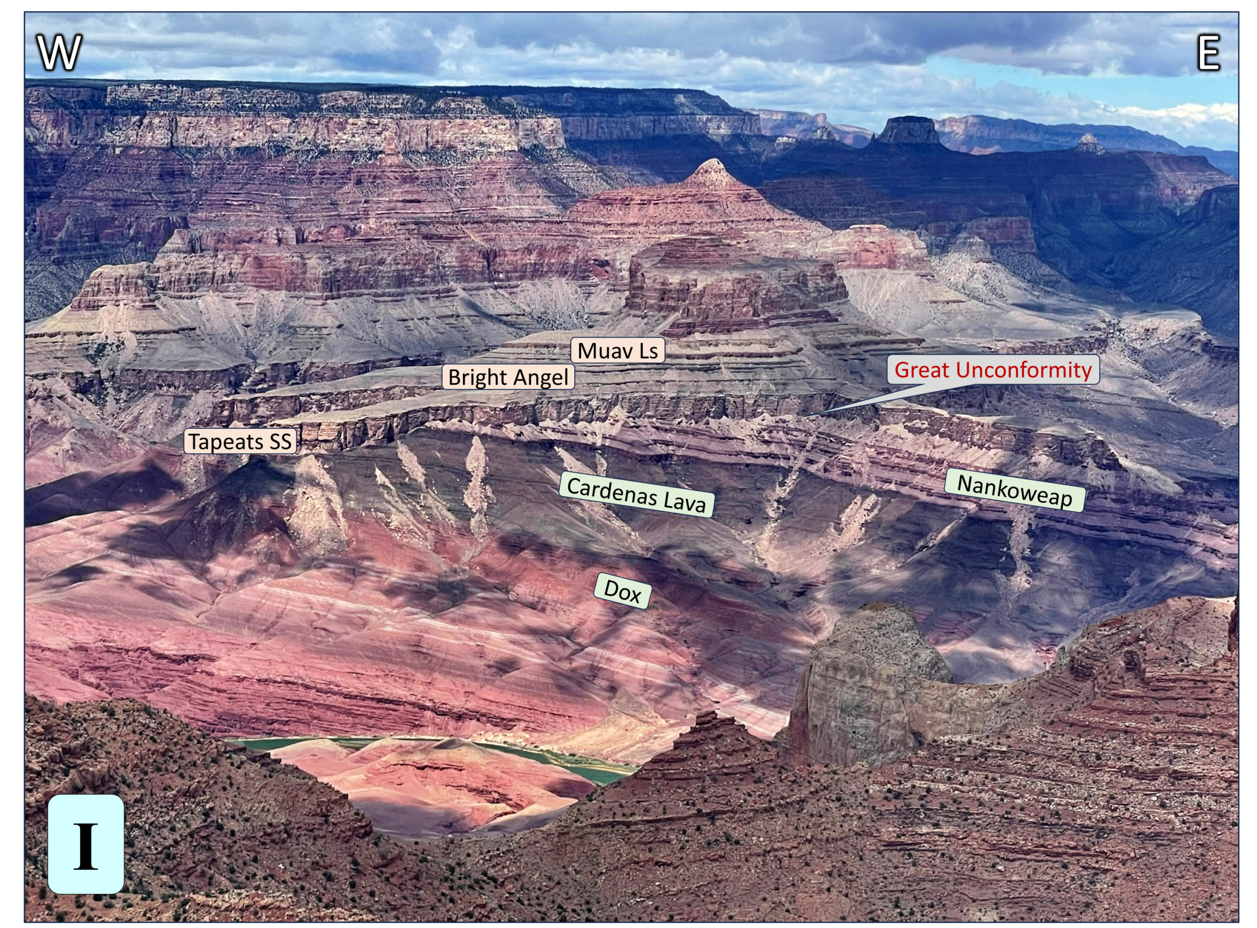
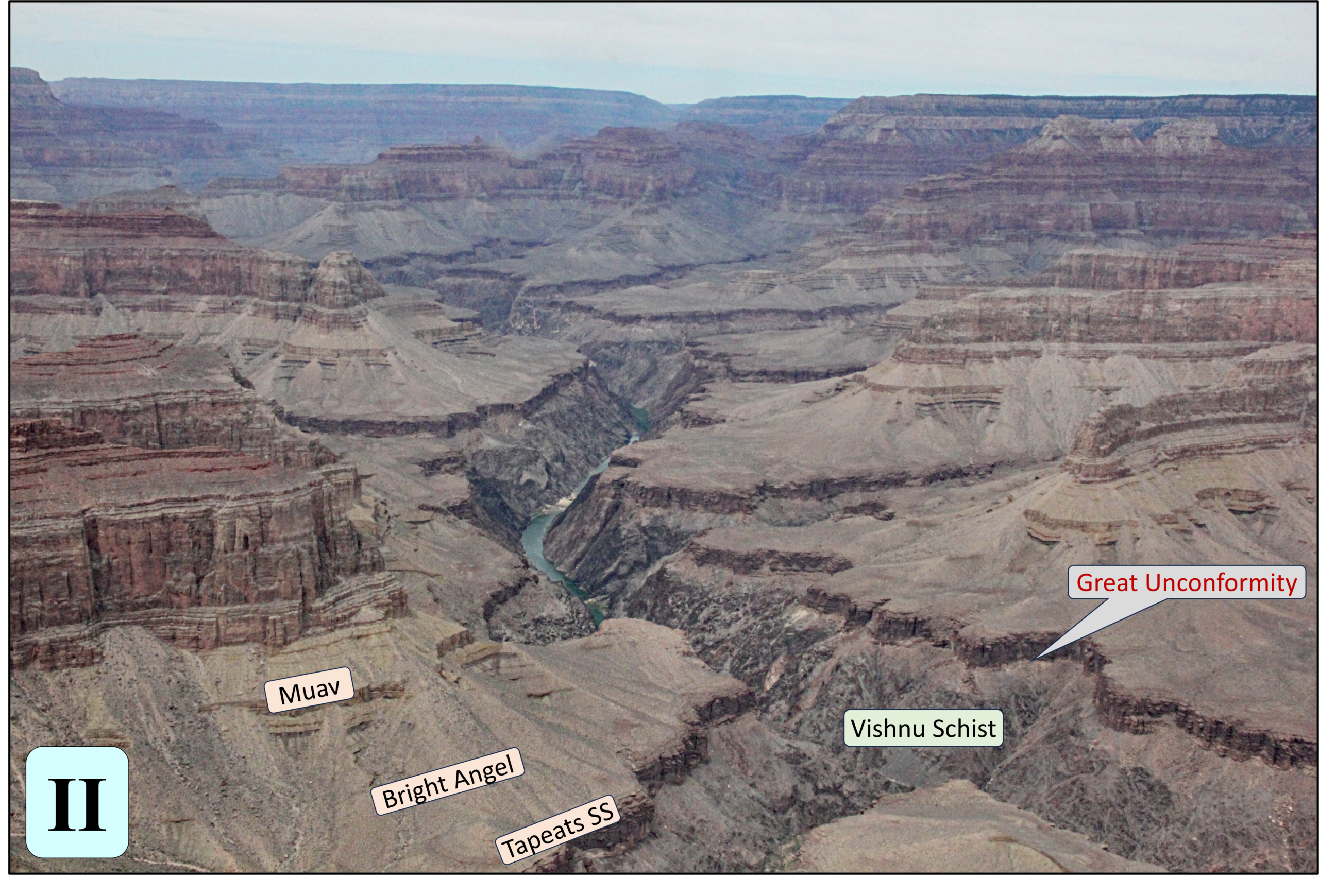
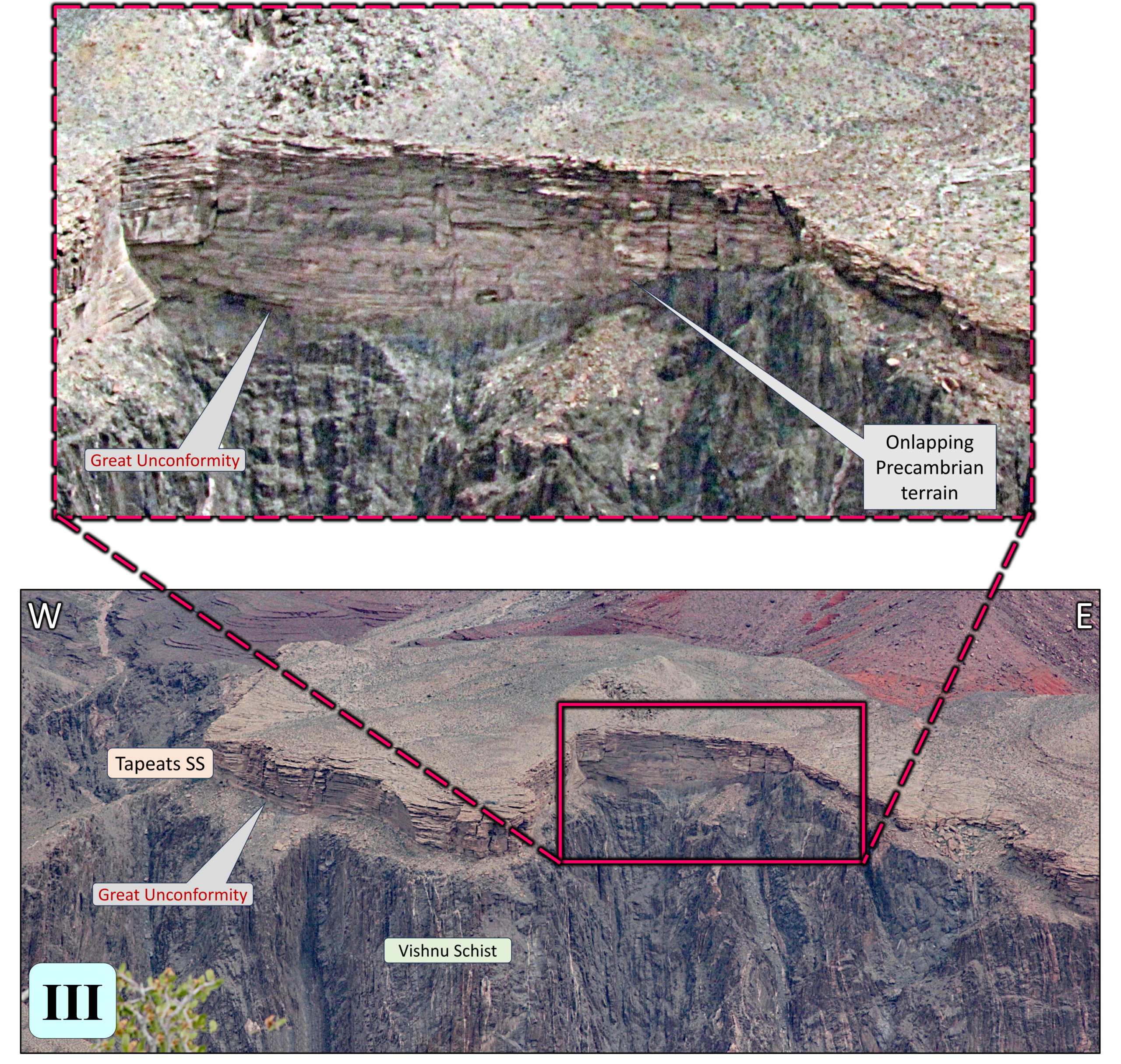
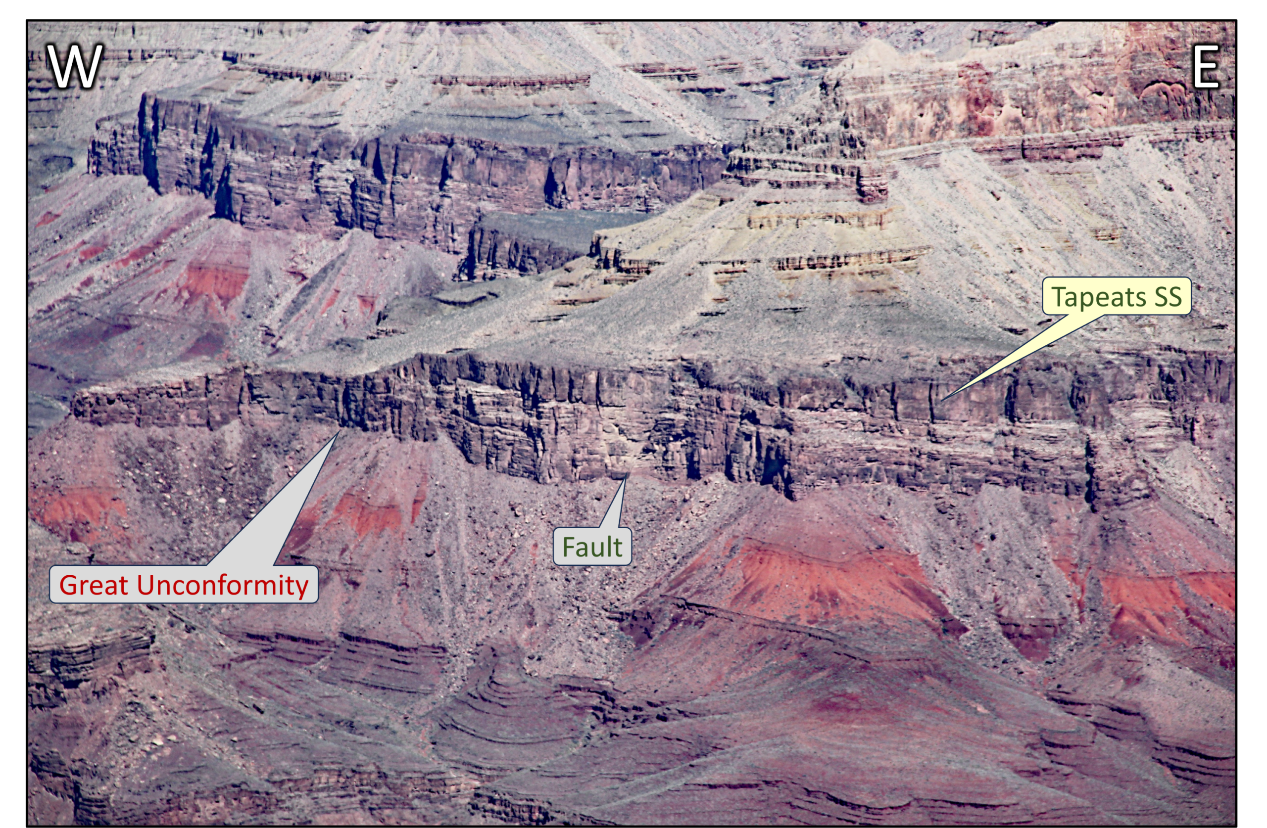
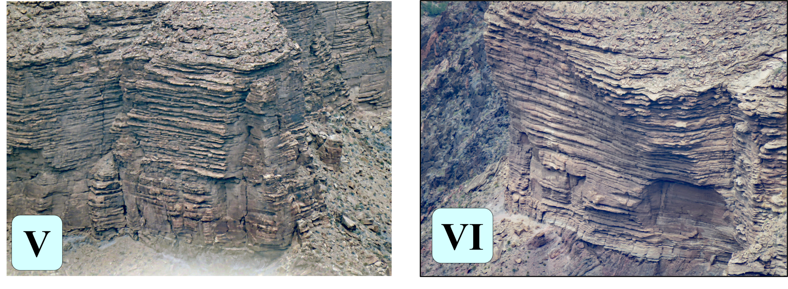
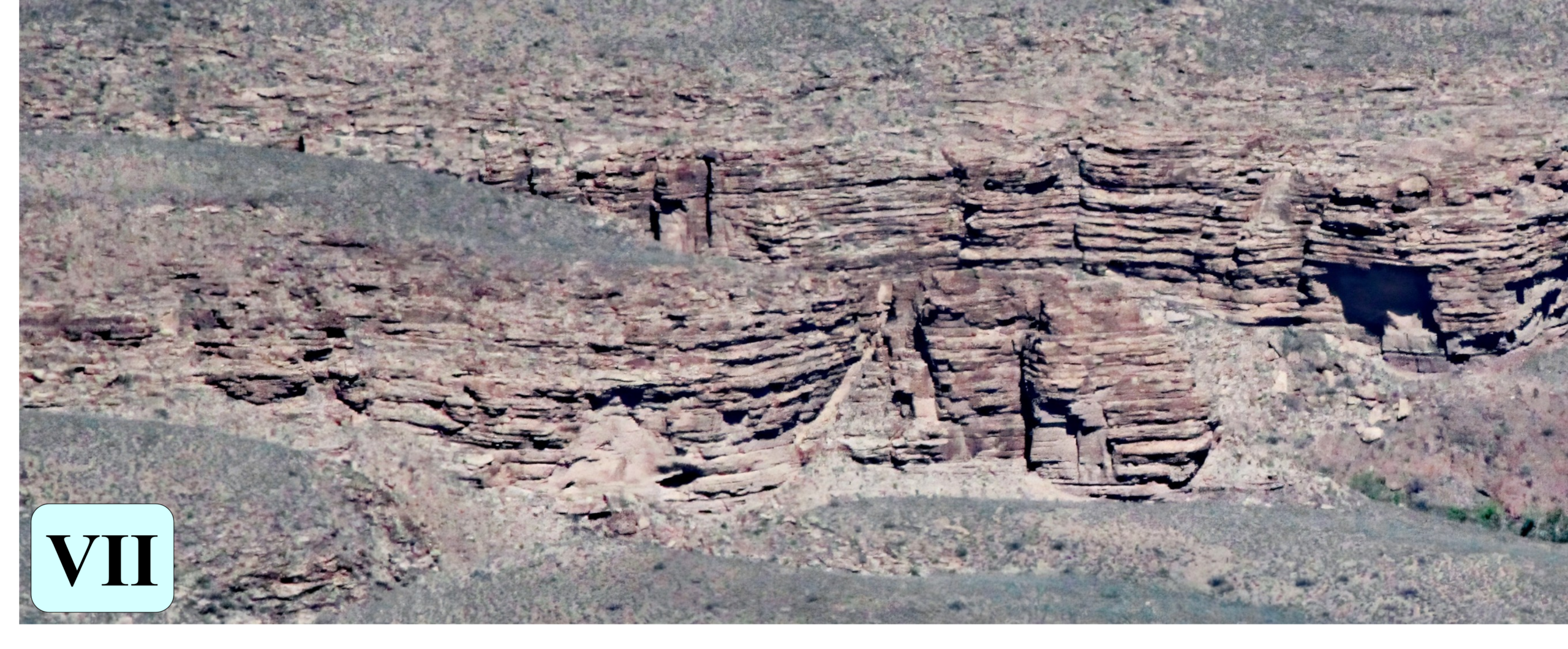
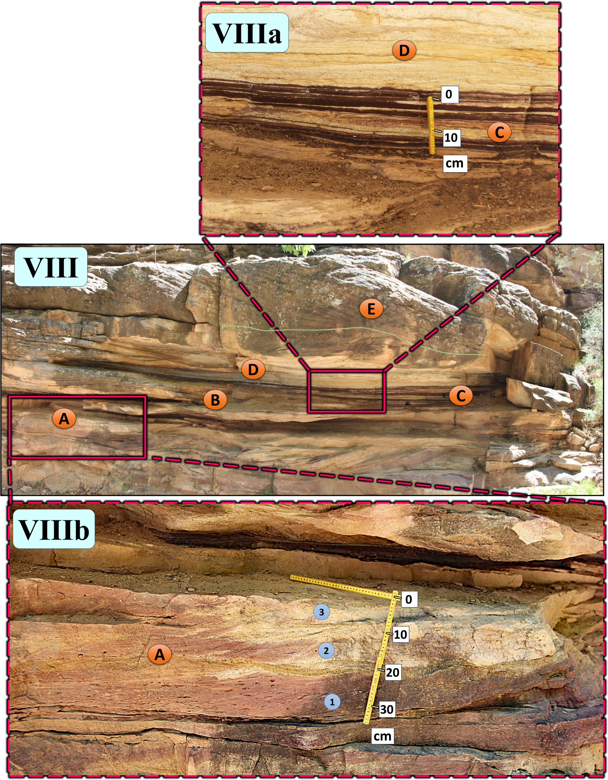
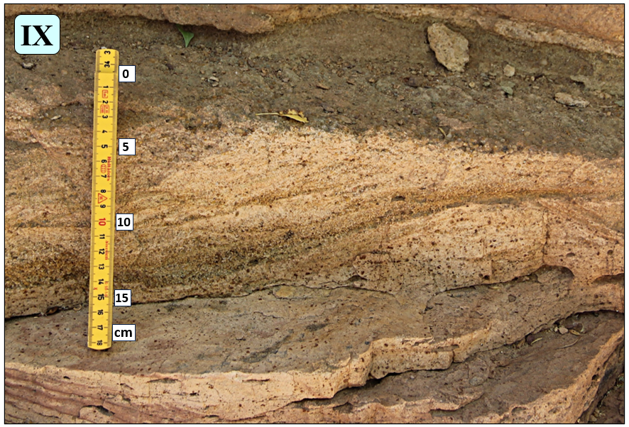
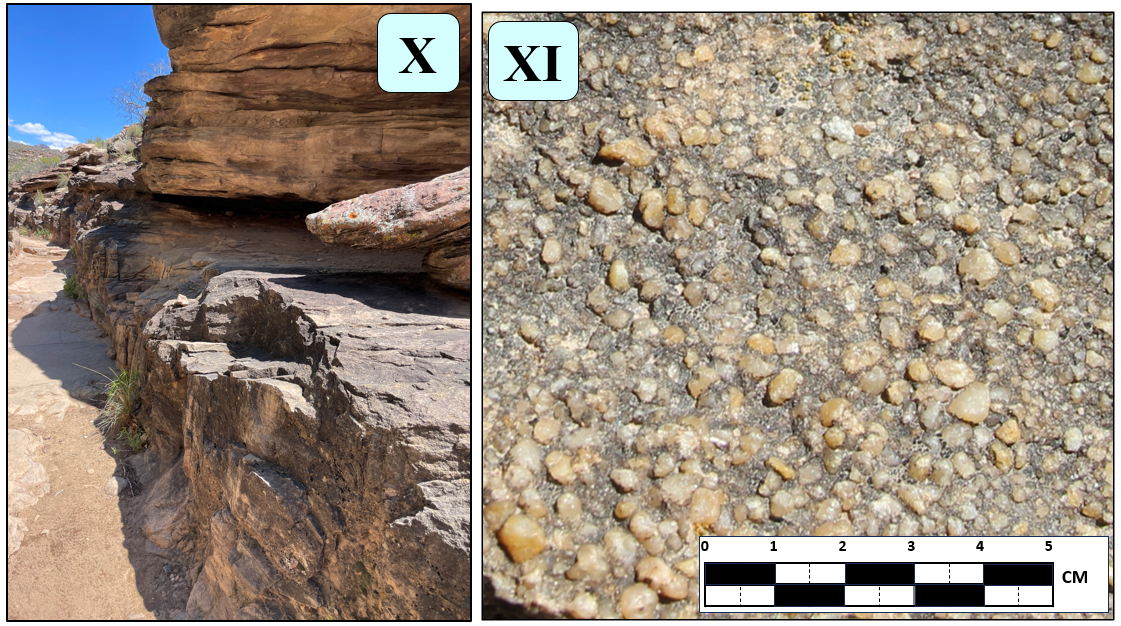
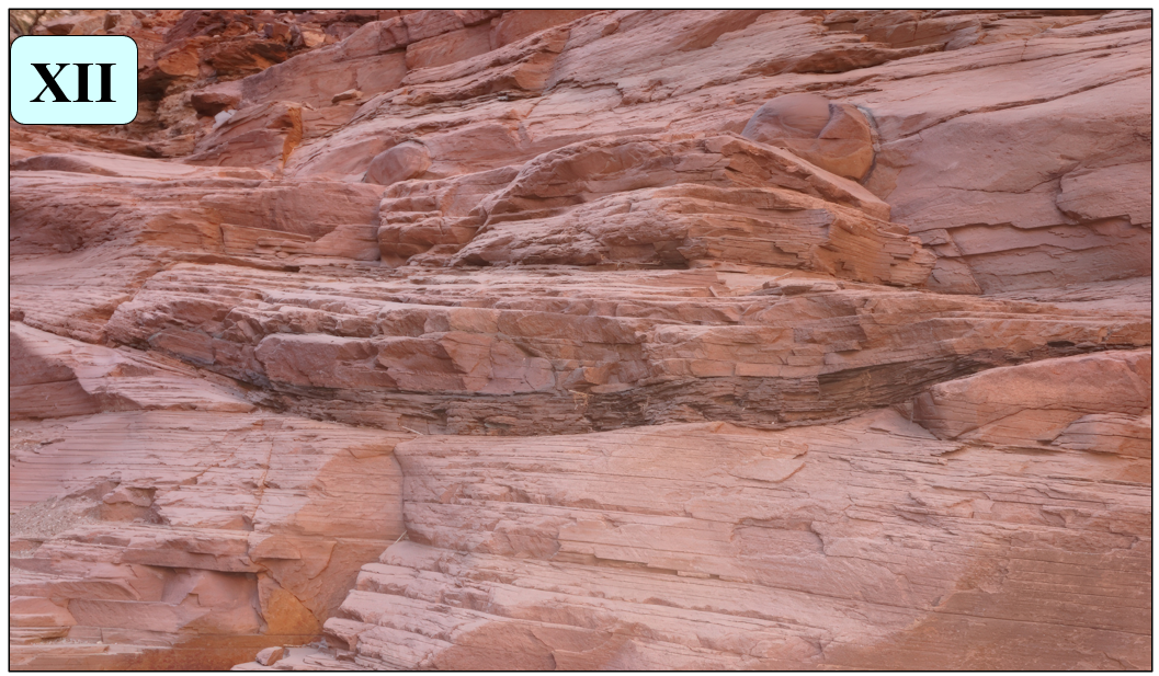
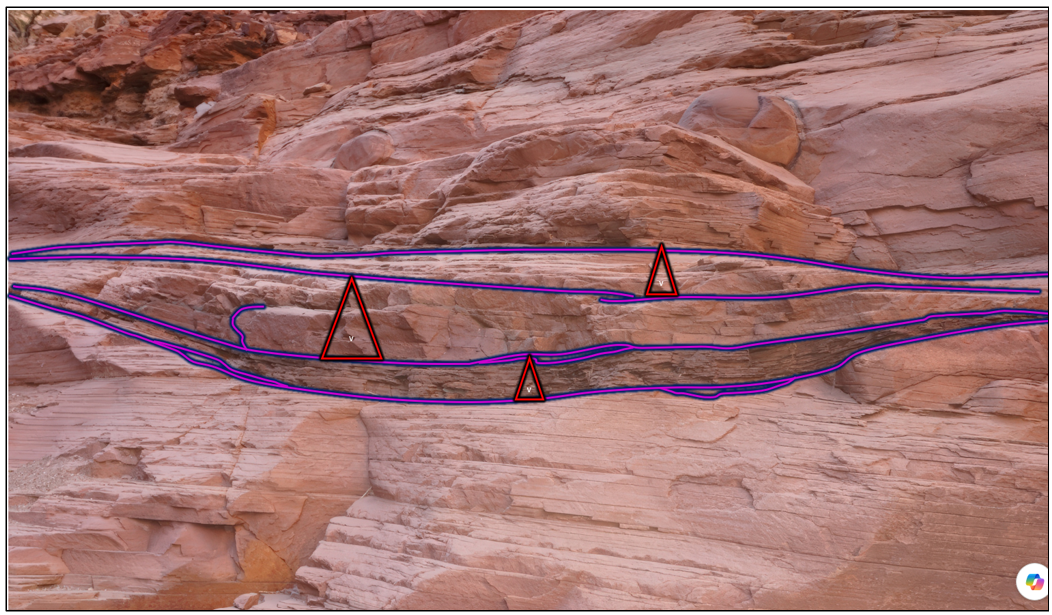
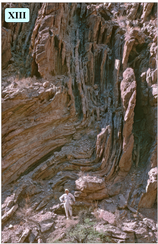
Recent Comments