
Printable PDF File: Reefs and deep time
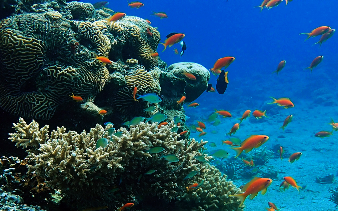
Shallow warm seas around the world today often contain wonderful bodies of life known collectively as reefs. Divers love to explore the amazing diversity of life found in them. We understand that they develop in particular water depth ranges and in particular temperature ranges. We find deposits from ancient reefs that grew through much of the last 500 million years. These give evidence of extravagant beautiful life that grew over a very long time with a changing cast of characters but with very similar processes to what we see today.
Perhaps the most spectacular reef today is the Australian Great Barrier Reef. (Figure 1) Wikipedia reports these general stats:
The Great Barrier Reef is the world's largest coral reef system composed of over 2,900 individual reefs and 900 islands stretching for over 2,300 kilometres (1,400 mi) over an area of approximately 344,400 square kilometres (133,000 sq mi).
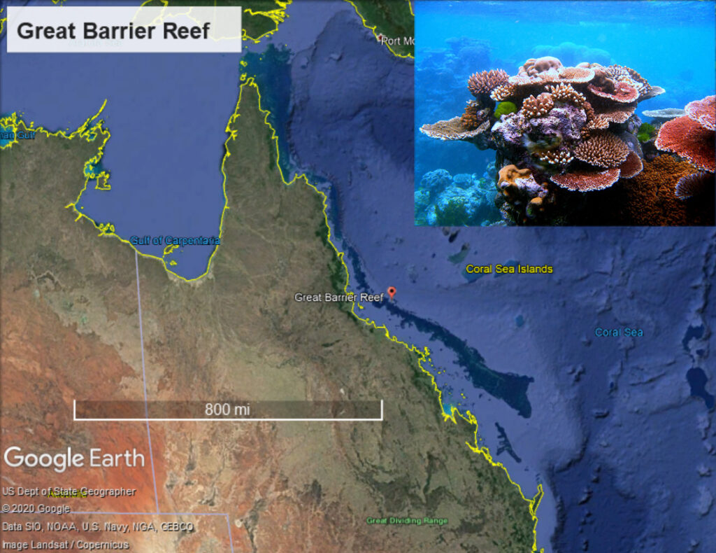 Figure 1. The Australian Great Barrier Reef is a wonder of God’s creation. (Map from Google Earth) Image from: https://en.wikipedia.org/wiki/Great_Barrier_Reef#/media/File:Coral_Outcrop_Flynn_Reef.jpg

Another great site is: https://greatbarrierreeftourscairns.com.au/blog/how-was-the-great-barrier-reef-formed/
It is a truly amazing feature and I hope to visit it one day. The reef structures are formed by many types of coral, both in place and as they die, often becoming rubble. The Great Barrier Reef, is 400 feet (122 m) thick and is believed to have grown over the last ten to twenty-five thousand years (Gischler, et al, 2011). According to Wikipedia, “The Great Barrier Reef Marine Park Authority (GBRMPA) considers the earliest evidence of complete reef structures to have been 600,000 years ago.” However, most recognize that reefing began much earlier, perhaps as much 20 million years ago. Geologists recognize that sea level has risen and fallen many times over that period, killing the reef at times and allowing new reefs to grow back and form the trend again.
An age of 6-8000 years does not really fit with any YEC model, especially if you realize that you also have to account for all of the underlying strata as well. (see the time terminology in terms of the Young Earth Stratigraphic Column and normal geologic column (tab) at the base of this page: https://jesusinhistoryandscience.com/?page_id=668). I don’t know of any YEC that would claim that this or other current reefs began forming during Noah’s flood. Large flood events bring large amounts of muddy sediments into the water, killing filter-feeders such as coral, and largely kill any reefs that existed before such a flood. Noah’s flood would have been the ultimate example of this.
How could thick reefs of many different ages have grown up after the flood? Many YEC claim really high rates of growth for reefs. We can debate the rates that apply today and about how to extrapolate them into the past. I would argue that there are physical limitations on how fast processes such as reef growth happened in the past. Regardless of how fast reefs grew in the past, we can all agree that no actual reefs would have developed during Noah’s flood. If we find even one bed of rock or set of beds that took longer than 1 year to form, then we know they were not deposited during the flood. Genesis tells us the how long Noah’s flood was in very specific terms – one year. If we recognize in-place deposits from a reef, then we know that they were not formed during the flood because they did not form over the timespan of less than a year.
Are we confident that there were reefs found back in the rock record? Absolutely. Geologists recognize reefs throughout the rock record, throughout the Phanerozoic, the strata that contain most of the fossil record. For example, in my study area, Figure 2, below shows reefs identified in 9 different geologic periods. Other geologic periods had reef deposition in other parts of the world. Remember that YEC with some background in geology recognize that these periods are real, at least in the sense that the represent the order rocks were deposited in, even if they disagree about the time involved. Although YEC authors disagree widely on which intervals represent flood deposits, all of these “reef rocks” are considered flood deposits by some YEC, except for the Holocene reefs currently growing in the Gulf of Mexico.
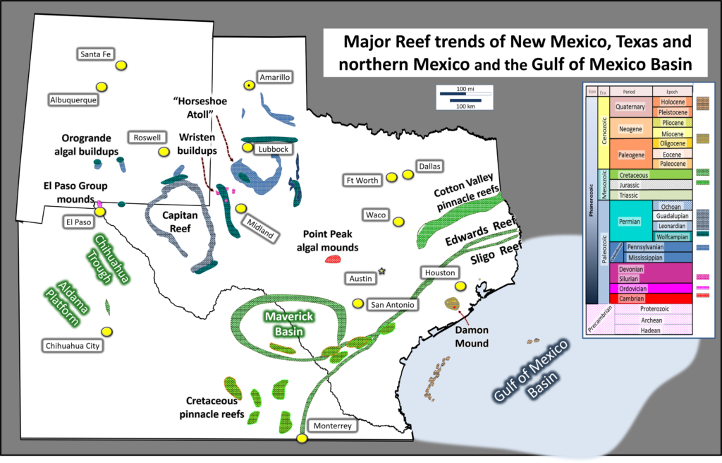
Figure 2: Map showing major features identified as “reefs” from this author’s study area and the geologic periods when they formed.
Geologists recognize ancient reefs in what are interpreted as “flood deposits” by every YEC author. How do these writers explain such units? They obviously cannot consider them reefs. In reality, they must each provide an explanation that allows all these thick special units of limestone, at times hundreds of meters thick to have formed in much less than one year. Whitcomb and Morris (1961) proposed this: “During the flood, extensive reefs formed in the warm waters of the antediluvian seas would have been eroded and deposited, often giving the appearance now of an ancient reef of great extent”. For a 6000-year-old earth, this would mean great thicknesses formed in 1656 years (see Unit 2 on the Young Earth Stratigraphic Column)
Snelling (2009) suggested that many fossil “reefs” were actually “accumulations of sediment swept in by water” or “rapidly accumulating debris flows”. Certainly, some limestones and other carbonates formed by such methods. In other cases, we can be confident that that is not how they formed. It is important to look at the terminology. Early on, the term reef was used to refer to any hard water bottom that represented a hazard for ships. At the other end of the spectrum, some YEC want to restrict the term to refer only to coral reefs such as are found in warm seas all around the world today. However, geologists recognize that many other organisms formed reefs back in older units.
Geologists often have not helped matters. Some geologists have used the term reef for any limestone units that they considered prospective for oil and gas. Why? Many well-known oil reservoirs are referred to as reefs, and as a result, some decided that the term reef could be used to entice investors to drill prospects. Thus, just because someone called a unit a “reef”, it may not be true. If the purpose here is to recognize reefs that are significant in terms of being clearly identifiable and having taken significant amounts of time to form, then that means a fairly general definition of a reef will do. With that purpose in mind, I will use the term reef for carbonates that meet these criteria:
- Represent a concentrated organic accumulation
Many ancient and modern lifeforms, both animals and plants, have left accumulations of lime skeletons. Examples here include algae, corals, and rudists (ancient clams that grew much larger than our modern species).
- Is a build-up or mound
Reef will be used for accumulations that had topographical relief. Other organic lime accumulations also took long times to form but would not here be referred to as reefs.
- Is locally derived, some growing in place
Modern coral reef deposits include some coral that grew in place but much is broken and much ends up eaten by various animals. Even so, the reefs considered here all have some species that are commonly found in their growth position.
- Has associated facies (mappable characteristics) that are consistent with modern reef settings
Surrounding facies should be consistent with modern reef settings. In each of the cases on the map shown, internal facies of the reefs have been mapped in as much detail as the deposits will allow. They are consistent with facies on and around modern reefs.
Consider a quick test: a unit deposited as proposed by Snelling might have a large accumulation of organic materials and potentially could have been washed into something that would look like a mound. However, it would not have many organisms preserved in growth position and the components would not map as facies consistent with deposition in a reef.
Now let’s look at a few examples from the rock record.
1. Cambrian- Point Peak Formation near Mason, Texas
Rocks from the Cambrian period were deposited early in the history of life, at least in terms of complex life. I realize that most of you are don’t exactly have the geologic periods by memory, so use the Geologic Stratigraphic Column tab at the bottom of this page to help: https://jesusinhistoryandscience.com/?page_id=668. In the Point Peak Formation near Mason, Texas, they contain layered fossils known as stromatolites (Figure 3). These ancient algal mats were formed as cyanobacteria (blue-green algae) developed films that trapped other sediment to form layers. Stromatolites such as these developed in an intertidal zone, the zone between high tide and low tide. They demonstrate regular tides over some period of time. Modern laminations have been measured to grow at rates of 1.6 to 5.6 years per lamination (Petryshyn 2013). Modern examples from Shark Bay have been studied and found to grow at average rate of less than 0.4 mm per year (Chivas, et al, 1990). Certainly, rates may have been faster in the past, but there are limits to what we might expect.
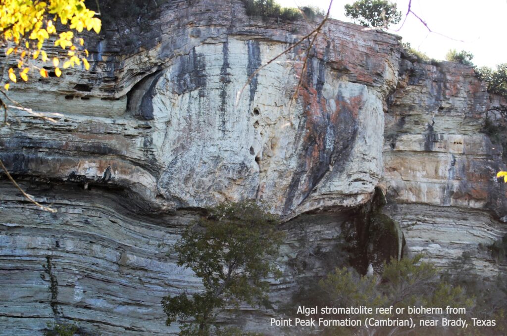
Figure 3. Algal stromatolite reef or bioherm from Point Peak Formation (Cambrian)
The Cambrian stromatolites in the Point Peak Formation developed int o localized organic buildups that are considered bioherms or reefs (Nielson and Barker 2013; Ahr 1971; Chafetz 1973). Such isolated organic buildups are typically called patch reefs and though the organisms forming them are different today, the characteristics are very similar. In this area, such patch reefs are preserved all along a long cliff face. The Cambrian reefs grew up to fifty feet (15 m) thick by 100 feet (30 m) long.
Do these fit my criteria?
- They were concentrations of algal mats.
- The mats formed very distinct local mounds.
- The algal mats definitely grew in place.
- The internal and external characteristics are very similar to modern patch reefs except that we don’t have coral or other modern species present.
In almost all YEC models of geology, the Cambrian was deposited in the early flood. (You can find a chart of published YEC reports here: https://jesusinhistoryandscience.com/?p=1221). It is really hard to imagine algal stromatolites that are normally diagnostic of intertidal deposits forming in a flood. If we were to apply the rates of deposition that are observed today, 50 feet (15 m) of stromatolites would indicate 3750 years of deposition. Deposition in the early part of Noah’s flood would have taken place over in minutes to weeks. The contrast is obvious.
2. Pennsylvanian- “Horseshoe Atoll”
Regardless of the terminology that we use, carbonate stratigraphers all agree that large organically-bound, wave-resistant features grew in the Pennsylvanian period in what is now West Texas. The largest and best known of these was the “Horseshoe Atoll” (Wilson 1975; Burnside 1959). Carbonate mounds formed in a partial circle that look a bit like a horseshoe (Figure 4). The shape is also similar to atolls such as grow in the Pacific but the origin is different. This particular feature held over 2.5 billion barrels of recoverable oil (much has now been produced) and has been studied in great detail. My first task when I started with Mobil Oil in 1980 was looking (unsuccessfully) for new prospects for this area.
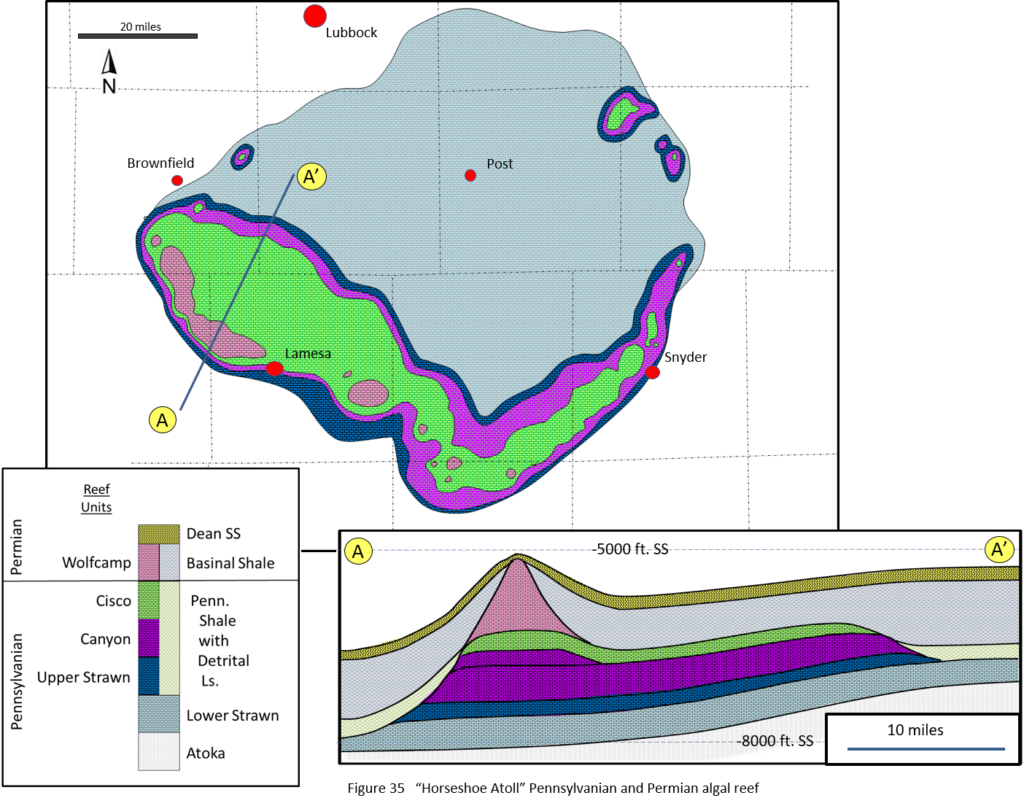
Figure 4 showing maps and cross section thorough the Pennsylvanian “Horseshoe Atoll in West Texas
Let’s look at the criteria that I use to define a reef:
- The “atoll” has a high concentration of fossils of platy algae, fusulinids, crinoids, foraminifera, bryozoans, etc.
- These are very large distinct mounds that died and regrew in several phases.
- The mounds were largely held together by platy algae that grew right on the mounds. Many times, the reef was brecciated (broken up) by storms and then were re-cemented by algae.
- Facies bodies have been mapped through the reefs reflecting a complex history as one would expect over bodies that grew for periods of time, and were drowned and exposed at various times. These porosity units control the movement of oil and water today.
The Horseshoe units are 3000 feet (900 m) thick at their thickest point. Studies show that as the overall basin subsided, the mounds grew for as long as their growth was able to keep pace with the subsidence. When the sea level dropped, the reef was exposed and freshwater dissolved away some of the limestone, creating porosity that was later filled with oil. Wilson (1975) reports that as many as twenty layers of porous limestone are separated by shales that were laid down when the water deepened again. It takes time for a basin to subside and for reefs to be established and for thick reefs to form. It takes more time for the sea level to drop and the limestone to be dissolved and then more time for the basin to subside again and the porous limestones to be covered with marine muds. Since this happened twenty times, it indicates significant time passed. All YEC authors that I have read consider Pennsylvanian rocks to have been deposited in the flood, but they disagree with whether it is early, middle or late in the flood. Regardless, only a brief time is available in any YEC model. These mound just did not form that fast. Generating all of the fossil material alone in the few years in the YEC model before the flood doesn’t work, let alone during it.
3. Permian Guadalupian – Capitan Reef
Probably no ancient reef in the world has been studied and described as much as the Capitan Reef in West Texas. This 350-mile-long (560 km) reef surrounded the Permian Delaware Basin in the Guadalupian series (late Permian). Portions are preserved in the Guadalupe National Park, in the Capitan and Guadalupe Peaks. (Figures 5 and 6) It has been drilled in wells hundreds of times and calibrated over and over. We can walk the rock on either side to understand the setting in great detail. We can find portions which slid and rolled down the ancient slope. Among the many fine published reports are these:
Jim Lee Wilson, 1975. Carbonate Facies in Geologic History, New York: Springer-Verlag.
Peter Scholle, 2000. “An Introduction and Virtual Geologic Field Trip to the Permian Reef Complex, Guadalupe and Delaware Mountains, New Mexico-West Texas.” Retrieved April 04, 2013, from New Mexico Bureau of Geology and Mineral Resources, Peter Scholle: http://geoinfo.nmt.edu/staff/scholle/guadalupe.html#genset
Peter Scholle, Goldstein, R., and Ulmer-Scholle, D. 2007. “Classic Upper Paleozoic Reefs and Bioherms of West Texas and New Mexico.” Retrieved 04 04, 2013, from New Mexico Bureau of Geology and Mineral Resources, Open-File Reports: http://geoinfo.nmt.edu/publications/openfile/downloads/OFR500-599/500-525/504/ofr_504.pdf
John Hills, 1972. “Late Paleozoic Sedimentation in West Texas Permian Basin.” AAPG Bulletin, 2303–2322.
Norman Newell, Rigby, J., Fischer, A., Whiteman, A., Hickox, J., and Bradley, J. 1953. “The Permian reef complex of the Guadalupe Mountains region, Texas and New Mexico—A study in paleoecology.” San Francisco: Freeman.
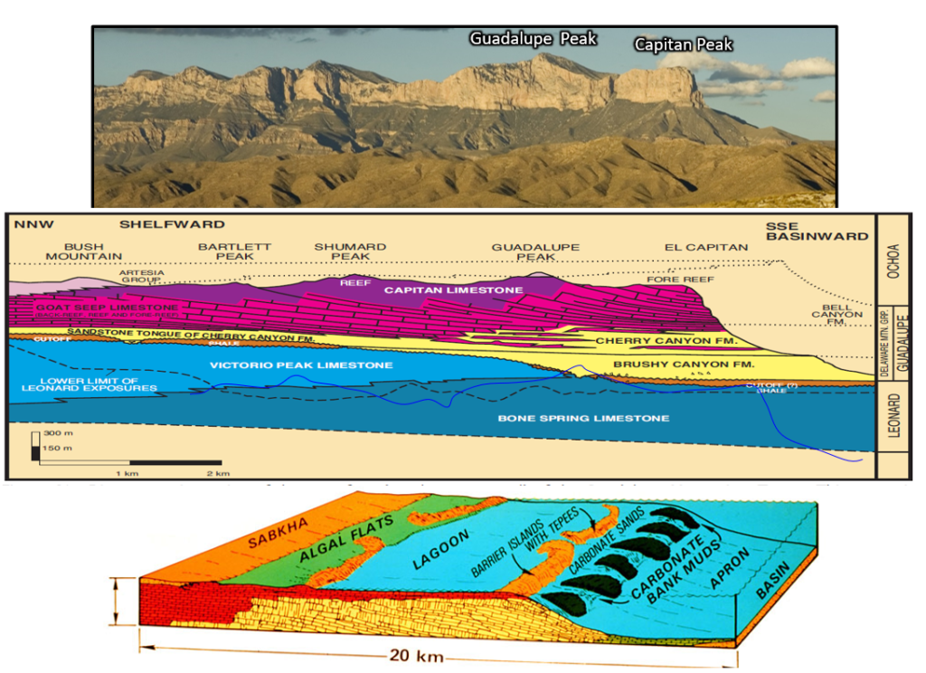
Figure 5. Carbonate clinoform packages showing the late Permian shelf edge in the Guadalupe Mountains in West Texas and New Mexico. Below is a model of what that the area looked like at the time the units were deposited.
Profile: Reproduced by permission of the New Mexico Bureau of Geology and Mineral Resources and Dr. Scholle (2000). Originally from (King, Geology of the Southern Guadalupe Mountain, Texas, 1948); Model: Reproduced by permission of Christopher G. St. C. Kendall (2005).
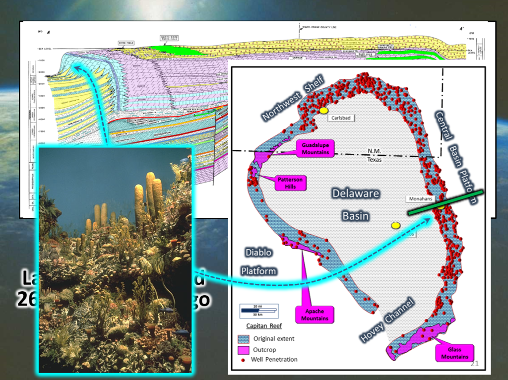
Figure 6 Here is a profle and map of the Capitan Reef with a picture of what it might have looked like. Read more about it in this post: https://jesusinhistoryandscience.com/?p=1101
Does this meet my criteria for a “reef” in this document?
- The Capitan formation has a very high concentration of many different fossils.
- The reef formed as a mound running for 350 miles. Relationships are clear in outcrops, wells and on seismic.
- The reef builders included thirty-five different species that include sponges, bryozoans, algae, crinoids, and other animals (Fagerstrom and Weidlich 1999). Many are found in growth position where they grew.
- Depositional facies have been mapped many different ways reflecting different workers emphases. They compare beautifully to modern analogs, though the species were very different.
If the Capitan Formation represents an ancient reef, then the flood geology interpretation fails dramatically. YEC publications and Web sites commonly cite a paper by Stuart E. Nevins titled “Is the Capitan Limestone a Fossil Reef?” (Nevins 1972). Nevins was a pseudonym used by Dr. Steven A Austin as a graduate student, apparently because of concerns that his YE views would have worked against him in pursuing a PhD in geology (Numbers 1993). The young graduate student questioned the work of other geologists, apparently based on a short bit of field work, suggesting that the formation is
“composed primarily of broken fossil fragments in a fine-grained matrix of lime silt and sand which were not wave-resistant when deposited”.
“Reef-forming organisms which could bind sediments and build frameworks are either altogether absent or largely inconspicuous. The available data certainly do not require many thousands of years for the Capitan to accumulate, and, therefore, seem to present little problem for Biblical chronology. Instead the lack of large organically-bound structures, which would grow during thousands of years, suggests that the deposition was very rapid. It is proposed that the Capitan Limestone accumulated either during the last stages of the Noachian Flood or shortly thereafter.”
This opinion is not shared by anyone who has worked the area in detail. The Capitan formation just was not deposited as part of a major flood. It was the last of a series of reefs that grew along the margins of a Permian basin over a long period of time (in terms of the YEC models). It is a part of one the best analogs of ancient depositional environments anywhere in the world.
4. Cretaceous – Rudist Reef Trends
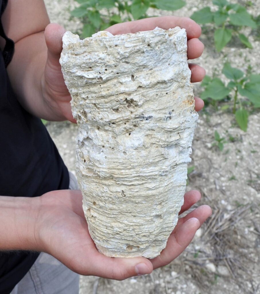
Figure 7 Rudist fossil from France (Wikipedia)
The next example that I will use comes from the Cretaceous. Most people think of dinosaurs from this period such as the Tyrannosaurus Rex, not reef forming animals. The most important reef formers in the Cretaceous were the rudists, a sort of super-sized clam (Figure 7). These clams grew together along long reef trends that extended most of the way around the Gulf of Mexico from the Yucatan Peninsula to Florida, longer than the modern Australian Great Barrier Reef. The Stuart City Reef trend grew at this time as shown on the map in Figure 2. The reefs were repeatedly exposed to fresh water leaching. Porosity from this freshwater leaching is very important to Texas because this allows these ancient reefs to hold what is perhaps the most important resource that comes from rocks: fresh potable water. The Edwards limestone is the largest aquifer for the state (Eckhardt 1995–2013). Evaporitic facies with gypsum and anhydrite were deposited behind the Cretaceous reefs just as they were in the Permian Basin (Moore and Bebout 1989).
Again, do they meet my criteria for a “reef” in this document?
- The rudist reefs include high concentrations of many different fossils.
- The reefs are recognizable in wells and on seismic as mounds of many forms.
- Caprinid and other rudists are often found in growth position.
- Facies maps of the facies associated with these reefs look very much like those from modern coral reefs. For instance, AJ Damman demonstrated effectively that the Edwards limestone reefs are directly comparable to the modern coral reefs of Bermuda (Damman 2011). Both areas have barrier reefs that protected a large backreef area where many lower-energy “circular to irregularly-circular reefs” grew.
These are vast deposits of concentrated fossils. That is easy to explain in a warm sea over long periods of time. I don’t see how they all could have lived and died in a few thousand years. If they formed before the flood, then where were they while all of the older rocks were being deposited? Remember, these creatures grew in one place, not walking around. Currently paleontologists estimate that rudist reefs grew one to five centimeters per year, much slower than the five to twenty centimeters per year estimated for coral reefs. I have found a few YEC authors who consider the Cretaceous as part of the post-flood deposits (unit 4 on Young Earth Stratigraphic Column). If that is so, then it would be very early in the post-flood time. The reefs along the Stuart City Reef trend are reported to be 2000-2500 feet (600-760 m) thick. If we used the paleontologist’s faster estimate of how fast they grew, this would suggest 15,000 years of growth. We actually know that the reefs did not grow continuously but were exposed at times, developing the porosity that is now filled with natural gas or perhaps more valuably, filled with fresh water.
If the 6000-year-old model for the age of the earth is used, then this model would demand that only a few hundred years would be available for the entire Mesozoic and Cenozoic sections, miles of rock. That would demand that these reefs formed in an incredibly short time, in a post-flood environment, presumably not much different than todays. These reefs just do not work as either flood deposits or post-flood deposits.
5. Cenozoic – Coral Reefs
The Cenozoic section in the Gulf of Mexico has one of the largest clastic (sand and shale) sections in the world. Filter feeders like corals normally don’t do well in such environments. It is not surprising that we don’t find many reefs in the rock record from this area. Large amounts of clastics usually overwhelmed carbonates, but in the Oligocene Epoch, a series of salt domes south of Houston provided environments shallower than the clastics and provided clean water areas for reefs to flourish (Frost and Schafersman 1978). The reefs were primarily built by branching coral, but fossils from many flora and fauna are preserved, just like are found on modern reefs. Detailed mapping shows all of the environments that one might expect for a modern reef. These are thin deposits, less than one hundred feet (30 m) thick and represent only a tiny part of the thickness of the Oligocene deposition and the time involved. Using the reef growth rates quoted for coral reefs earlier, we could guess that it took 150–600 years to deposit just this tiny fragment of the Oligocene section in the Texas Gulf Coast region.
The study area that I chose includes the western Gulf of Mexico. A discussion of reefs in the Cenozoic needs to include other areas in order to even begin to show how much evidence there is for reef deposition through time. Many books have been written about these reefs, but I will just use one example, a particular ancient reef complex from Indonesia. The reservoir for the Arun gas field on Sumatra, Indonesia, is a Miocene-aged coral reef. (Figure 8). This reef is one of a string of large coral reefs that grew in eastern Asia at the time. The field was extensively cored and studied by Mobil Oil Company after its discovery in 1971. Profits from this huge field kept the company alive during the mid-’80s, when oil prices went very low. The reef is up to 1100 feet (330 m) thick (Jordan and Abdullah 1985; Abdullah and Jordan 1987). Using the reef growth rate estimates from before, that would suggest that if rates were constant, it would have taken 1,650–6,600 years to be deposited. We know that the rates were not constant because the reef was periodically leached by freshwater and this leaching formed the porosity that held the gas and condensate that was produced. We also know that the field was buried later by approximately ten thousand (3 km) of sediment, allowing it to trap the hydrocarbons. It is clear that most of the thick, modern reefs such as the Great Barrier Reef, grew long after the Arun reefs were dead and buried.
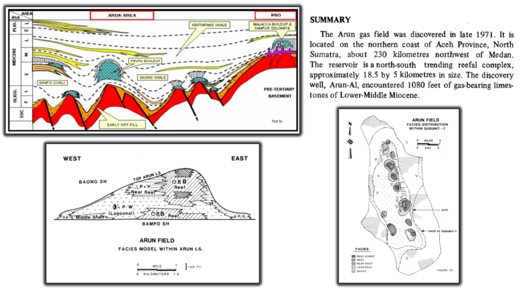
Figure 8. Illustrations of the reef that forms the reservoir for the Arun Gas Field, North Sumatra, Indonesia (Widarmayana, 2007) Notice all of this section above the red would have been in the Cenozoic and before the time of Abraham.
Discussion
I have highlighted reef trends that developed in 5 different periods in my particular study area. All of these are from intervals considered by at least some YEC authors as part of Noah’s flood. The oldest intervals are considered as flood deposits by all of the authors that I have read. Genesis records that Noah’s flood took place over a one-year period, such that if any of these rocks were deposited as a reef then they could not have been deposited by this flood. Much literature is available in the public domain on each of these, so it is not difficult to find data on each. Geologists use many different terminologies for carbonate buildups, but I used four criteria to recognize reefs that formed as organic in-place buildups. By these criteria, each of these are conclusively reefs.
Some YEC consider the intervals in which the last two examples were deposited as part of the post-flood interval. These younger examples also are problems for this interpretation. The Bible doesn’t give us any warrant to consider exceptional rates of growth before and certainly not after the flood. There is no reason to expect the growth of reefs after Noah’s flood to have been dramatically different than what we see today. Thus, when we see thick reefs to have grown in the Mesozoic or Cenozoic then we should expect that they took thousands of years to grow. We also see evidence that in each case, reef growth was interrupted periodically and the reefs exposed to fresh water that leached them and dissolved caves and porosity through them. The combination of reef growth and exposure reflects millions of years of activity. The Arun field in Indonesia show a reef that grew and was leached over millions of years and then buried by ten thousand feet of normal sediment. Many YEC are saying that this all took place after the flood, but if the earth is 6000 to 10,000 years old, then a maximum of 4500 years is available to deposit all of this, plus a lot more. I will expand on this aspect of the problem more in coming posts.
God did not attempt to deceive us with nature, including the rock record. The young earth creationist positions that: 1) the earth was created 6 to 10,000 years ago and that 2) much of the rock record was deposited as a result of Noah’s flood just do not fit the evidence. This does not mean that the Bible is untrue but that the YEC interpretation does not fit the evidence. I argue that an interpretation that fits both the Biblical record and the data from nature is more likely to be correct. I believe this is consistent with a careful reading of Genesis 1 and have outlined this in other posts. The record of nature is that God prepared earth for mankind over millions of years. Earth over this time period had a fascinating and beautiful variety of life, some of which grew as reefs. The sheer diversity of life in them is a valuable treasure for earth. Today, we appreciate the beauty and enjoy food from animal life. God seems to really enjoy both beauty and life.
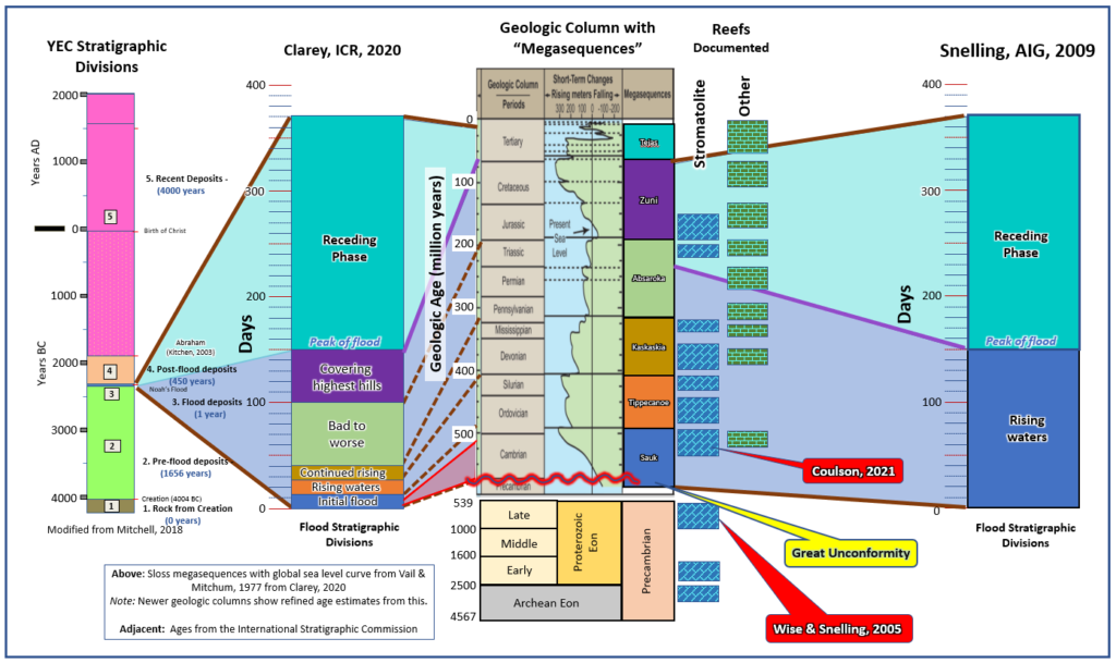
Here is an updated figure showing how key reefs around the world fit into the models proposed by Dr. Tim Clarey with ICR and Dr. Andrew Snelling with AIG. It is important to recognize that Wise and Snelling in 2005 published an article arguing that stromatolitic reefs in the Proterozoic could not have formed during global flood. YEC geologist, Dr. Ken Coulson argued the same for reefs in the Cambrian in Utah.
References Cited
Abdullah, M., and Jordan, C. J. 1987. Geology of the Arun Field Miocene Reef Complex. in Proceedings Indonesian Petroleum Assoc., Sixteenth Annual Convention, October 1987 (pp. 65–96). Jakarta: IPA.
Ahr, W. M. 1971. “Paleoenvironment, Algal Structures, and Fossil Algae in the Upper Cambrian of Central Texas.” Journal of Sedimentary Petrology 205–215.
Burnside, R. 1959. Geology of Part of the Horseshoe Atoll in Borden and Howard Counties, Texas. Washington: USGS Professional Paper325-B.
Gischler, E., Droxler, A., and Webster, J. 2011. “Facies and Diagenesis of Older Pleistocene Coral Reefs, Great Barrier Reef, Australia (IODP 325).” Retrieved March 08, 2014, from AAPG Datapages: http://www.searchanddiscovery.com/pdfz/documents/2011/50433gischler/ndx_gischler.pdf.html
Chafetz, H. 1973. “Morphological Evolution of Cambrian Algal Mounds in Response to a Change in Depositional Environment.” Journal of Sedimentary Petrology 435–446.
Chivas, A., Torgersen, T., and Polach, H. (1990). “Growth Rates and Holocene Development of Stromatolites from Shark Bay, Western Australia.” Australian Journal of Earth Sciences 113–121.
Damman, A. 2011. A Comparison of the Cretaceous (Albian) Edwards Limestone Bioherms of Central Texas with the Holocene Coral Reefs of Bermuda. Waco, TX: MS Thesis, Baylor University.
Eckhardt, G. 1995–2013. The Edwards Aquifer Web site. Retrieved April 06, 2013, from The Edwards Aquifer Web site: http://www.edwardsaquifer.net/geology.html
Fagerstrom, J., and Weidlich, O. 1999. “Strengths and weaknesses of the reef guild concepts and quantitative data: Application to the upper Capitan-massive community (Permian), Guadalupe Mountains, New Mexico-Texas.” Facies, 131–156.
Frost, S., and Schafersman, S. 1978. “Oligocene Reef Community Succession, Damon Mound, Texas.” Transactions–Gulf Coast Association of Geological Societies, 143–160.
Jordan Jr, C., and Abdullah, M. 1985. “Lithofacies Analysis of the Arun Reservoir, North Sumatra, Indonesia.” Retrieved 2014, from SEPM Online: http://notes.sepmonline.org/content/sepswgog/1/SEC3.body.pdf
Kendall, C. 2005. “Permian Basin Reef and Basin Fill West Texas and New Mexico: Explained Using a Framework of Genetically Related Carbonate, Clastic and Evaporitic Facies Geometries and Their Bounding Surfaces. Retrieved from http://www.powershow.com/view/15654b-NTU3Y/Permian_Basin_Reef_and_Basin_Fill_West_Texas_and_New_Mexico_powerpoint_ppt_Presentation
King, P.B. 1948. Geology of the Southern Guadalupe Mountain, Texas. Washington, DC: USGS Professional Paper 215.
Moore, C., and Bebout, D. 1989. Carbonate Rock Sequences from the Cretaceous of Texas, Field Trip Guidebook T376. Washington, DC: American Geophysical Union.
Nevins, S. (1972). “Is the Capitan Limestone a fossil reef?” Creation Research Society Quarterly 231–248.
Nielson, R., and Barker, C. 2013. Geology of the Western Llano Uplift, Fredericksburg to Mason, Texas March 2, 2013. Western Llano Uplift TAS 2013 Field Trip, (pp. 1–36). Nacogdoches, TX.
Numbers, R. 1993. The Creationists: The Evolution of Scientific Creationism. Berkley: University of California Press.
Petryshyn, V. 2013. Stromatolites in the ancient and modern; New methods for solving old problems. Dissertation, University of Southern California.
Snelling, A. 2009. Earth’s Catastrophic Past, Vol. 1 and 2. Dallas: Institute for Creation Research.
Whitcomb, J., and Morris, H. 1961. The Genesis Flood. Phillipsburg, NJ: Presbyterian and Reformed Publishing Co.
Widarmayana, I.W.A, 2007. “The Giant Arun Gas Field (North Sumatra) – Gas from Beneath the Earth to LNG Export – A 30 Year Success Story.” Proceedings, Indonesian Petroleum Association, Thirty-First Annual Convention and Exhibition
Wilson, J. 1975. Carbonate Facies in Geologic History. New York: Springer-Verlag.
Recent Comments