
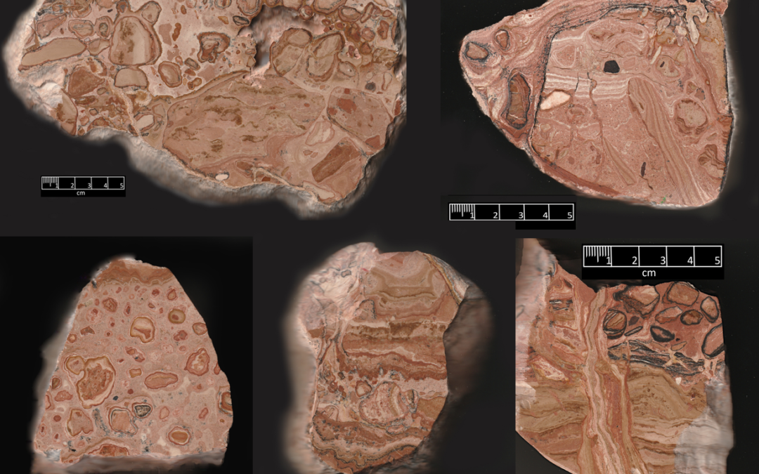
Who knew that dirt could be turned into a really interesting rock that can even be polished? The rocks we will be looking at started out as soil. We can even recognize that it was from a soil that formed in a dry climate. Well, semiarid, a lot like the climate in West Texas and eastern New Mexico today. Since these rocks were found in eastern New Mexico, this tells us that sometime in the past, the climate was much like it is today. West Texas always needs rain.
The rocks we will look at are called caliche or sometimes calcrete. As rain fell in the region, it picked up carbon dioxide in the atmosphere and formed a weak acid. This reacted in the soil to leave calcium carbonate, at first as just white crusts and threads. In these types of climates, there was enough rain to leach calcium down into the soil, but not enough to move it down and out of the system the way it would in wetter areas.
I collected the samples in the movie (Figure 1 above) along a road near Elida, New Mexico (Figure 2 movie and Figure 3). Making the dirt roads here involved bulldozing through the caprock caliche. It also is used as the aggregate that forms the road. Larger pieces rolled off to the side of the road. I enjoy walking along roads there, looking for pieces that have interesting colors and patterns.
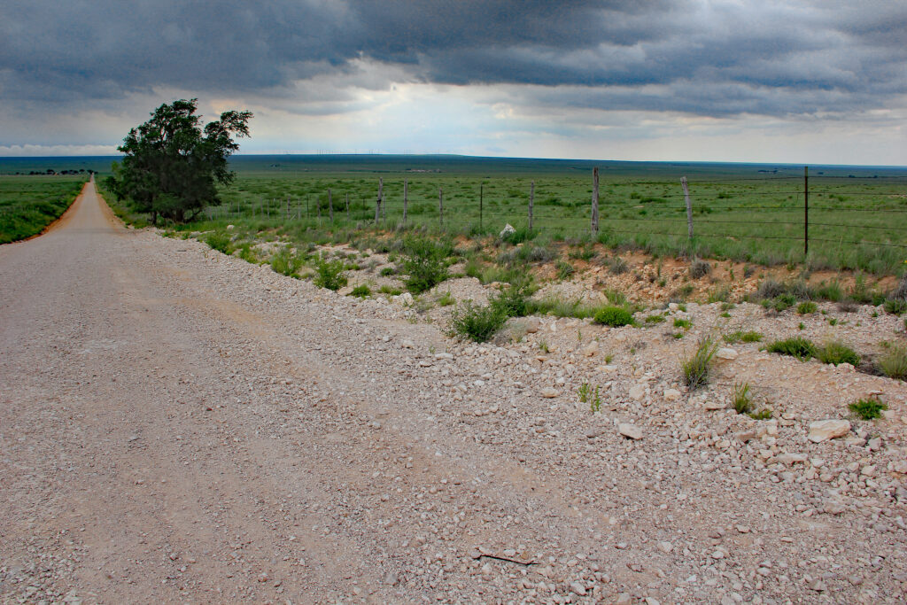
Figure 1. Collecting area in eastern New Mexico near the village of Elida
Figure 3. Caliche along the road, near Elida, NM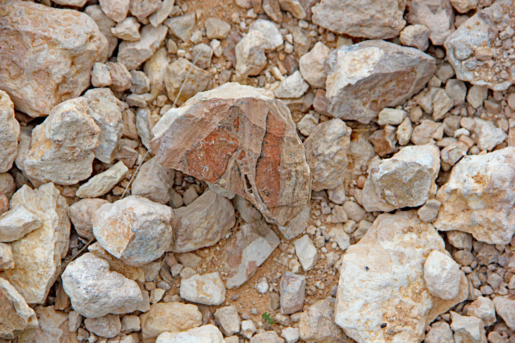
The caliche in the movie is at a very advanced stage of development, far beyond the early thin crusts and threads. The caliche here is often colored by iron (reds and pink) and iron and manganese (black). The patterns reveal a complex history as to how they were formed. As you look at them, think about how many storms these pieces represent. I found that hard pieces can be cut and polished.
Llano Estacado in New Mexico and Texas Vs. YEC and Flood Geology
Paleosols in a Global flood?

Evidences of a Young Earth??
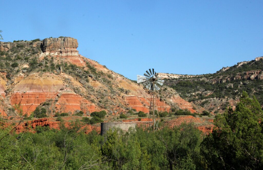
First, let’s look briefly at where they come from. This caliche is more resistant to erosion than the softer rocks below the caliche in this area and it forms a caprock that holds up the Llano Estacado, a broad plateau feature in West Texas and eastern New Mexico. It forms the top of the Ogallala Formation that extends northward to southern South Dakota. I grew up on the Llano Estacado in the village of Dora, labeled on the map. At the time, I never thought about how the caliche could be as beautiful as I have now found it to be.
The caliches of the upper Ogallala Formation cover an area of about 32,000 square miles (83,000 km2). It is roughly the size of the state of Indiana or the country of Portugal. It is even more impressive when you recognize that this is just a remnant of the original extent before it was carved down by erosion! In some areas, the caliche is quite thick. (Figure 5)
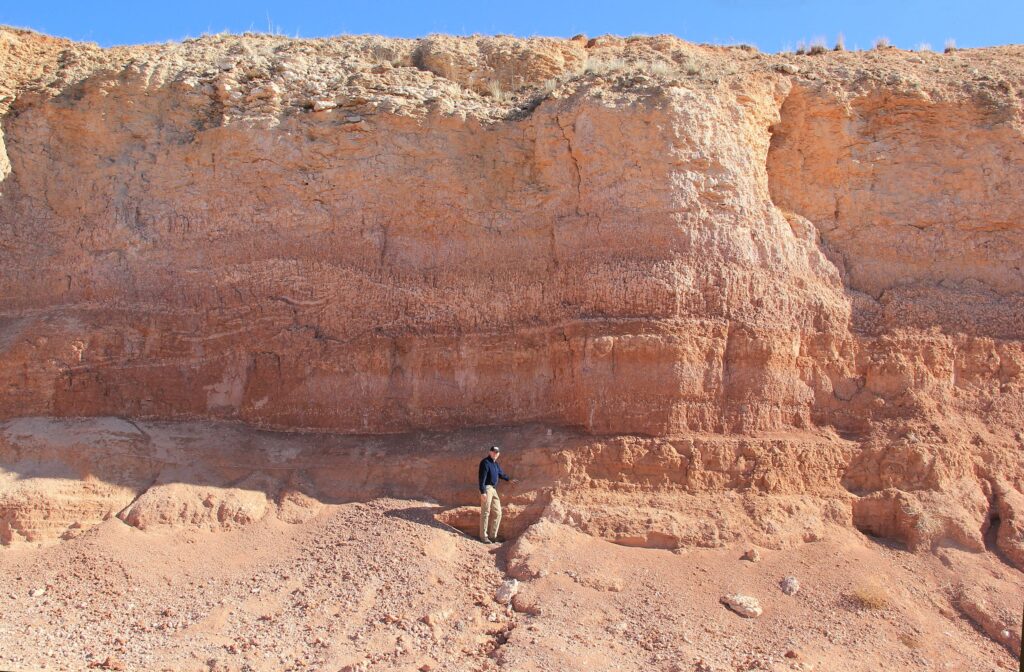
Figure 5. Roadcut north of Crosbyton, Texas. The caliche here is very thick, indicating that there was a very long period of fairly stable semi-arid conditions.
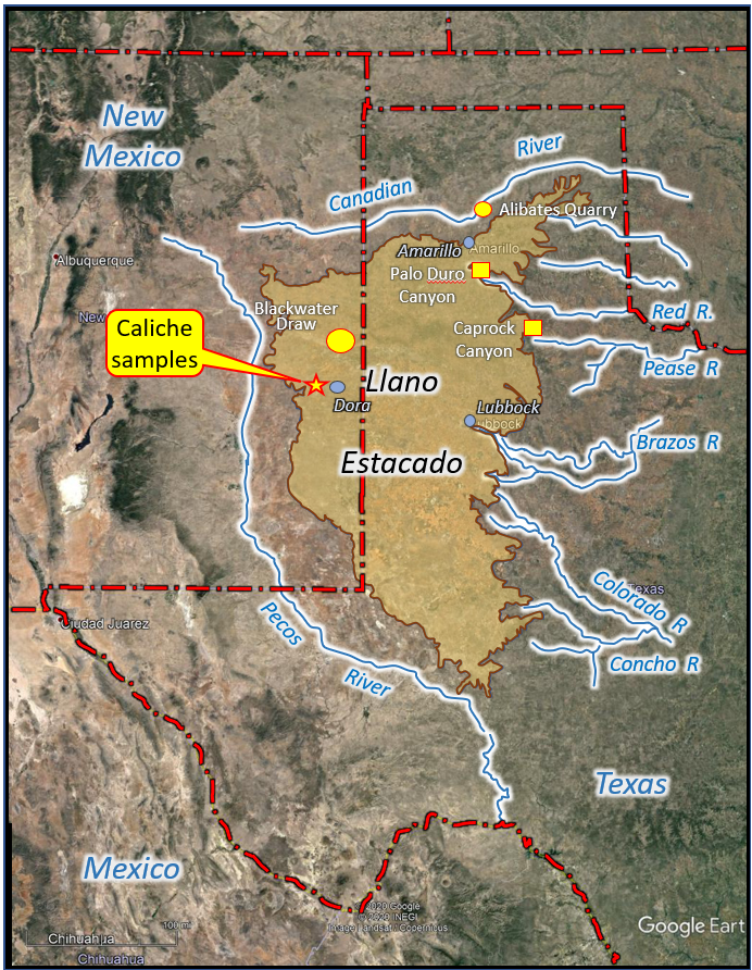
Figure 4. Llano Estacado mesa shown on a Google Earth map of the eastern New Mexico, West Texas region. Notice that a series of river valleys define it.
Stages of Calichification
We see caliche developing today so we don’t have to guess how it formed. (Figure 6) We can see a continuous spectrum of development from thin crusts to hardened caliche like the pieces that I polished.
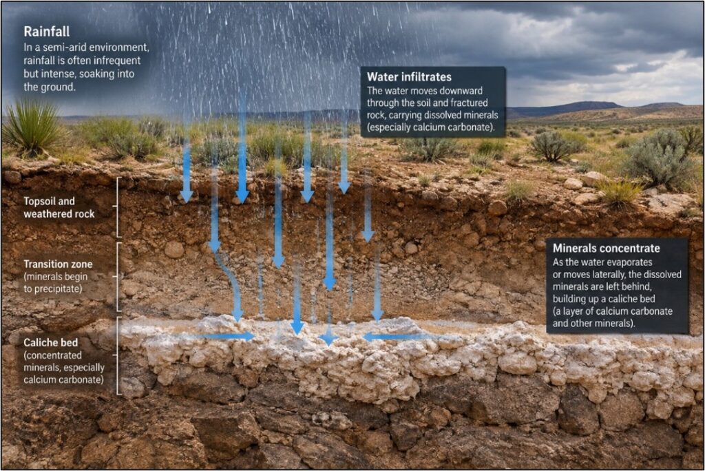
Figure 6. ChatGPT does a reasonably good job of illustrating how caliche horizons developed. When the rain did fall, it would seep quickly into the dry soil. It leached calcium carbonate from the upper soil but it precipitated and concentrated into caliche.
Although in nature, caliche formation is a continuum, soil scientists still recognize that it passes through a set of stages over time. Time, however, is just one of the variables involved. Climate does change today and did through deep time as well. The general setting, initial soil characteristics, the vegetation types and quantity also had roles in determining the type of caliche that developed and how it matured.
Figure 7 shows six stages that soils can go through to develop into really mature caliche rock like those that I polished (Soil Survey Staff 2024). It doesn’t mean that stage VI caliches are always older than those in stage I or stage II. It does mean that these soils went through more extensive concentration of calcium carbonate by these soil development (pedogenesis) processes. Across the Llano Estacado, ancient soils in the Ogallala Formation reached different developmental stages, although most contain sections ranging from stages III to VI.
This means that when we see Stage VI caliche, like the polished examples, we know that it developed along a trend of stages like those in Figure 7. We can recognize the caliche was not laid down as caliche. It began as little filaments and coatings of calcite (Stage I) in a non-calcareous soil. Such coatings can form relatively quickly. Nodules and concretions developed later and they grew and aggregated (Stage II). Eventually a solid layer of caliche developed, sealing off water below it (Stage III). Fine layers or laminations would have developed at the top and the calichification would have expanded (Stage IV). Stage V would have seen the formation of rounded features known as pisolites (Figures 8 and 9).
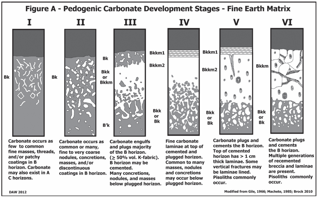
Figure 7. Stages of caliche (calcrete) development (Soil Survey Staff 2024)
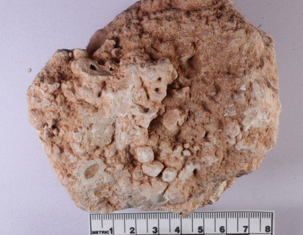
Figure 8. Pisolites in caliche
Figure 9. Pisolites cut and polished.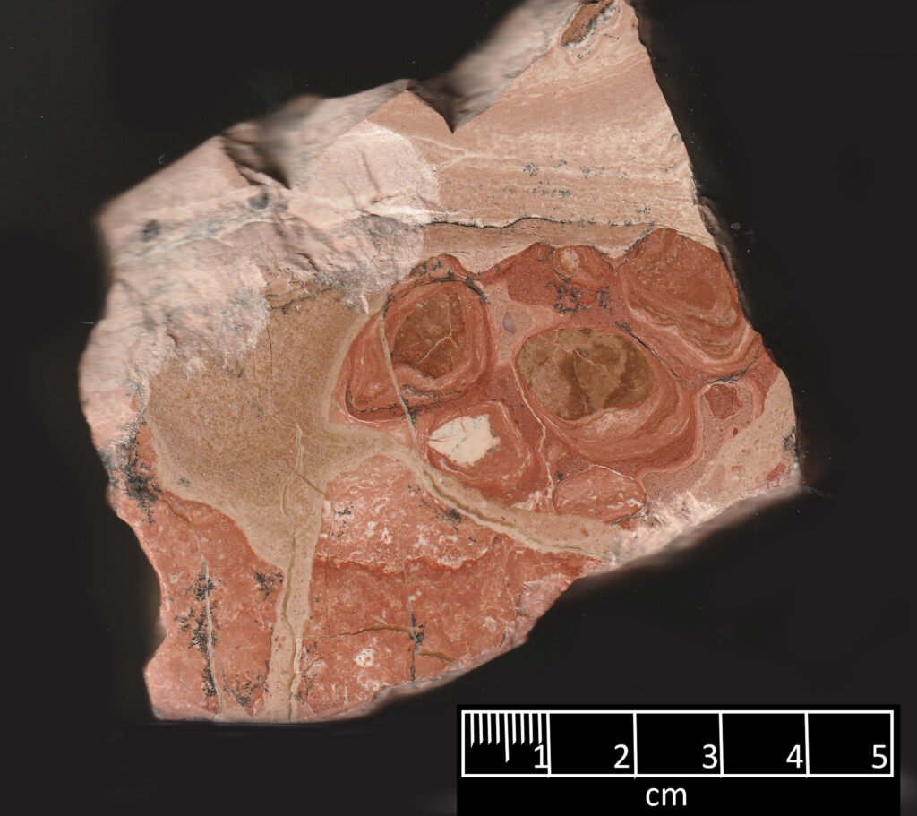
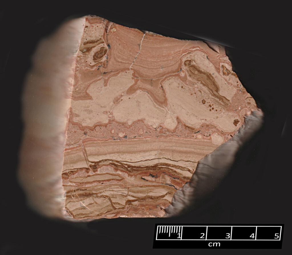
Figure 10. Ribbons and bands in caliche. More technically, these are known as laminations.
Figure 11. Brecciated laminated caliche cobble with later light- colored porous caliche.
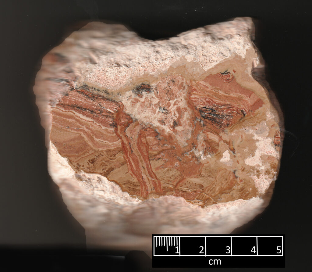
Figure 12. Rounded fragments. Notice that the coloration around them are consistently on the lower side of the pebbles. These are then called “pendular”, showing that they formed above the water table.
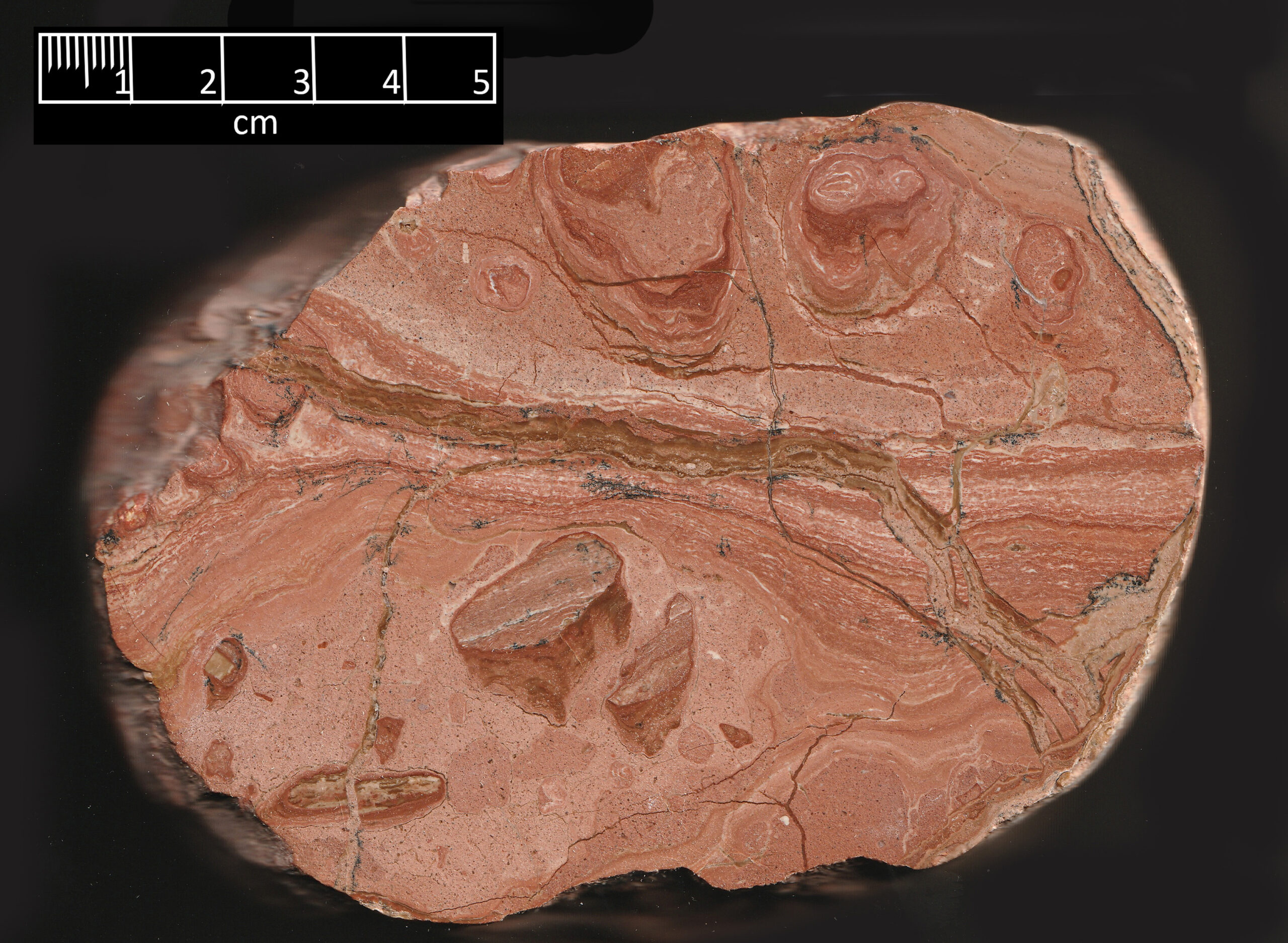
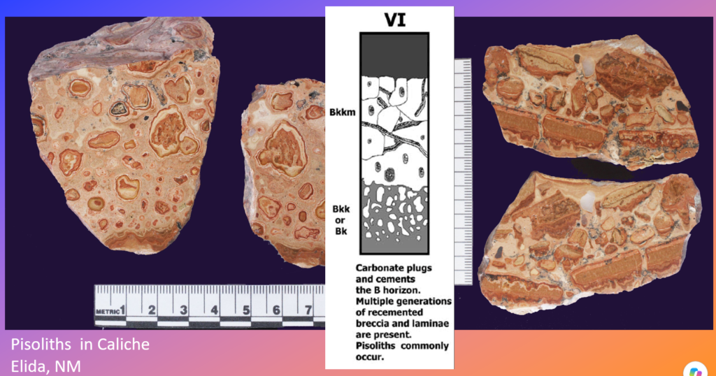
Figure 13. Stage 6 figure compared to some of the polished caliche from Elida, NM
Stage 6 caliche incorporates features from the earlier stages, but it has been broken up (brecciated) multiple times and recemented by later calichification. The caliche samples pictured are all stage 6, showing many phases of development. Figures 10,11, 12 and 14 all include portions that are laminated. They clearly are not in their original position, but have been broken and rotated around multiple times. The soft caliche around the cobble in Figure 11 formed more recently and shows what less mature caliche looks like. Every piece tells a story with many chapters.
How long did it take to form?
The ancient soils of the Llano Estacado and particularly the caliches of the Ogallala Formation have been studied many times by geologists. Many fine reports are available such as these: (Gustavson and Holliday 1985; Reeves 1970; Bachman and Machette 1977; Zhou and Chafetz 2009).
The Ogallala caprock spans a vast area and preserves evidence of soils that formed before sporadic and relatively sparse rainfall carried calcium downward, where it precipitated as calcite and produced caliche. It resulted from thousands of storms. How long did it take to accumulate? We will look at this later. The caprock is covered by later soils known as the Blackwater Draw Formation. How long did this take to form? How long did it take for the plateau to be carved into the shape that we see today? By any measure, such soils took time to develop.
The upper Ogallala Formation was deposited in the geologic epoch known as the upper Pliocene, telling us that the caliches to have been deposited approximately 1.5 to 3 million years ago, as most geologists would date them. Such a date is consistent with giving time for the series of soils to have developed that covered the Ogallala Formation. Many of these later soils also developed their own caliches. Water movement during later times continued to seep through the caprock caliche, further altering it. (see Figure 11).
How long would the caliche portion of the Ogallala have taken to form? I don’t have any specific details for this particular unit. A somewhat younger unit in Spain has been studied in detail. Geologist Ian Candy and a team tested caliche (calcrete) units there that were up to 6 meters thick (nearly 20 feet). This is similar to the thickness of the Ogallala caprock in many places. They reported this:
“Carbonate was sampled and dated from three locations within the profile: (1) below the lower surface of clasts within the hardpan (representing the earliest cement present—207±11 ka), (2) from the center of cement filled pores within the hardpan (reflecting the final plugging of the calcrete hardpan—155±9 ka) and (3) from the laminar calcrete overlying the hardpan (representing the latest cement—112±15 ka). These results show that the hardpan took between 73 and 31 ka to form, whilst the mature stage V profile took between 121 and 69 ka to form.” (Candy et al. 2004)
The stage 6 caliche of the Llano Estacado was probably similar. The thickness and maturity of the caprock varied, but this amount of time would have allowed for the thousands of rains that washed the carbonate down into the soil.
How long did it take to form?
The ancient soils of the Llano Estacado and particularly the caliches of the Ogallala Formation have been studied many times by geologists. Many fine reports are available such as these: (Gustavson and Holliday 1985; Reeves 1970; Bachman and Machette 1977; Zhou and Chafetz 2009).
The Ogallala caprock spans a vast area and preserves evidence of soils that formed before sporadic and relatively sparse rainfall carried calcium downward, where it precipitated as calcite and produced caliche. It resulted from thousands of storms. How long did it take to accumulate? We will look at this later. The caprock is covered by later soils known as the Blackwater Draw Formation. How long did this take to form? How long did it take for the plateau to be carved into the shape that we see today? By any measure, such soils took time to develop.
The upper Ogallala Formation was deposited in the geologic epoch known as the upper Pliocene, telling us that the caliches to have been deposited approximately 1.5 to 3 million years ago, as most geologists would date them. Such a date is consistent with giving time for the series of soils to have developed that covered the Ogallala Formation. Many of these later soils also developed their own caliches. Water movement during later times continued to seep through the caprock caliche, further altering it. (see Figure 11).
How long would the caliche portion of the Ogallala have taken to form? I don’t have any specific details for this particular unit. A somewhat younger unit in Spain has been studied in detail. Geologist Ian Candy and a team tested caliche (calcrete) units there that were up to 6 meters thick (nearly 20 feet). This is similar to the thickness of the Ogallala caprock in many places. They reported this:
“Carbonate was sampled and dated from three locations within the profile: (1) below the lower surface of clasts within the hardpan (representing the earliest cement present—207±11 ka), (2) from the center of cement filled pores within the hardpan (reflecting the final plugging of the calcrete hardpan—155±9 ka) and (3) from the laminar calcrete overlying the hardpan (representing the latest cement—112±15 ka). These results show that the hardpan took between 73 and 31 ka to form, whilst the mature stage V profile took between 121 and 69 ka to form.” (Candy et al. 2004)
The stage 6 caliche of the Llano Estacado was probably similar. The thickness and maturity of the caprock varied, but this amount of time would have allowed for the thousands of rains that washed the carbonate down into the soil.
Young Earth Creation and Flood Geology
It is, however, true that those holding the Young Earth Creation (YEC) interpretation of scripture and nature will not consider the above timeframes possible. Their flood geology proposal interprets much of the rock on the Earth’s surface to have resulted from Noah’s flood. How do they interpret the Ogallala Formation? There are two leading camps, holding different views in this regard. The largest YEC organization is Ken Ham’s Answers in Genesis (AIG). Dr. Andrew Snelling, formerly the Director of Research for AIG, has published many articles expressing their view of the timing of Noah’s flood in the rock record. The second camp is affiliated with the Institute for Creation Research (ICR). Dr. Timothy Clarey is the director of research at the Institute for Creation Research (ICR) and has published a different interpretation for which rocks were deposited during Noah’s flood. Though the views are different, both would force the deposition of the Ogallala into a very tiny window of time.
Figures 15 and 16 illustrate how these two proposals compare. Both figures have four columns that represent hypothetical columns of rock as interpreted from various points of view. The left column is scaled to vertically represent just over 6000 years and represents the YEC view of the history of the Earth divided into the periods of time when they would interpret sediments to have possibly been deposited. There is no reason to expect all such periods to have sediments preserved at any one spot. The lowest part represents rocks formed over the “creation week” of Genesis 1. The third column from the left shows the geologic periods of time in which most sediments were deposited, regardless of how long they were. Flood geologists, including Dr. Clarey and Dr. Snelling recognize that these periods are valid observations regarding the relative ages of the rocks, though they differ from most geologists regarding how long these periods were by several orders of magnitude. This column is scaled in millions of years as recognized by geologic organizations such as the International Stratigraphic Commission. Older rocks are omitted. The second and fourth columns expand on how the authors—and, by extension, their organizations—place these rocks within different phases of Noah’s flood. Both of these flood geology proposals and others that have been published interpret vast amounts for rocks to have been formed during Noah’s flood and then in the short time between the flood and the days of Abraham. Notice that Dr. Clarey interprets the top of the flood deposits to be near the top of the Tertiary Period or to use another terminology, near the top of the Cenozoic Era. He interprets the Ogallala formation to have formed near the last of Noah’s flood, though he has not referenced the caliche specifically. Dr. Snelling places the top of the flood deposits at the top of the Mesozoic Period, the time of the dinosaurs. He interprets all of the Cenozoic rocks to have formed after the flood, though presumably before the time of Abraham. The pink on the first column of Figure 15 extends from Abraham’s day to the present. In many places the difference between the views of Clarey and Snelling involves sedimentary section that is several miles thick.
Figure 16 expands the late Mesozoic era and the Cenozoic era. In conventional dating, the Cenozoic period represents the last 66 million years. The Ogallala Formation had to be deposited very quickly in either of these models. If the Ogallala were deposited during the flood as Dr. Clarey proposes, then it had to happen over perhaps 30 days. The final caprock would have been a short portion of this. Dr. Snelling’s proposal could allow perhaps 200 years for the Ogallala formation. Again, the caprock caliche would have been a fraction of this.
There is clearly a major disconnect between the flood geology proposals and the consensus views of most geologists. We have a single unit that extends over a very large area and the data is consistent with it alone having taken 10 times longer to form than the entire history of the Earth in YEC models. The saying is that Rome was not built in a day, but this is like saying that Rome actually was built in one day or maybe just a few hours. What kind of options might a flood geologist appeal to? I have found two articles that provide the most extensive thoughts on this subject from a YEC perspective. Both are from the 2009 book, “Rock Solid Answers” and are by Peter Klevberg (BS- Engineering Science) and Rick Bandy (BS – Forestry) and in one of the articles they were joined by the prolific YEC author, Michael Oard (MS- Atmospheric Science) (Klevberg and Bandy 2009; Klevberg et al. 2009). What kind of answers to they propose?
One option would be to say that the caliche actually formed in a soil that developed hundreds of times faster than they do today. Klevberg et al. (2009) wrote, “Caliche can form quickly enough to clog drainpipes”. No doubt crusts of fine-grained caliche can be formed relatively quickly, but that has little to do with extensive caliches like the Ogallala caprock. Flood geologists frequently appeal to rates that far exceed what are considered feasible by normal physics. Geologist recognize that rates in the past could have been different than today, but they also recognize that there are limits to how much some processes could have been accelerated. Rates of calcification have been estimated by several methods by geologists, but all recognize that deep time was required.
Some YEC, including Klevberg, Bandy and Oard, explain the extreme rates of sedimentation demanded by the models as having resulted from post-flood conditions having been wetter and the flood sediments having been easier to erode. That is no help for calcium concentrated in arid soils. More rapid deposition involves more water moving through the system. More water movement is not consistent with the arid to semiarid conditions that are demonstrated by the caliches of the Ogallala or by other caliches (calcretes) that developed in many other units. Soil formation is a slow process and it is especially slow in relatively arid environments.
Another option that flood geologists such as in the cited articles is to suggest that ancient caliches really weren’t caliches at all. Klevberg, et al. (2009) report that “identification of ancient BK horizons (caliche or a soil cemented by calcium carbonate) is difficult at best.” One tact is to claim that the caliches really were not formed by soil processes at all (or to use more technical language, they were not formed by pedogenesis and it is true that some caliche did develop in other ways. If the Ogallala caprock was not formed by soil processes, then how could it have formed? One YEC proposal is that caliches originated by rapid chemical precipitation formed either during the receding stages of the Genesis Flood or in the post-flood period under unique, highly cataclysmic environmental conditions.
No one should seriously propose that the Ogallala caprock is not caliche or that it was not formed by pedogenesis. All stages of development of caliche in soils are evident. Ancient roots and ant nests are recognized (Mitchell 2021). The only reason to try to interpret this differently would be because the development of an ancient arid soil would not be considered possible because of a priori assumptions.
What does it tell us about claims that Noah’s flood was global? This tells us nothing about whether or not Noah’s flood was a historical event. It does provide another difficulty for placing a global flood in the rock record. If it wasn’t a deposit formed during the flood, could the flood have been before or after it? It just took far too long to form to place the flood earlier than the Ogallala. Noah did not live millions of years ago.
What about afterward? Stratigraphically younger than this on the Llano Estacado are found some of the earliest evidences of humans in North America, about 12,000 years BP. There is no evidence of any global catastrophe between the Ogallala and the units that contain the Clovis points from early Paleoindians (Haynes 1995; Holliday 1997; Gustavson and Holliday 1985). No global catastrophic flood occurred after the Ogallala caprock formed.
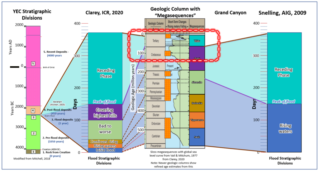
Figure 15 Stratigraphic columns as interpreted by flood geologists vs by conventional consensus geology. It shows a sharp contrast between flood geology vs. consensus geology and a contrast between the flood geology proposals. Box is expanded in Figure 16.
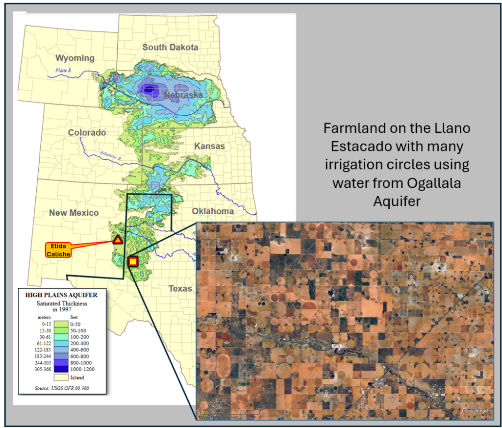
Figure 16. Zoom in on the upper part of Figure 15, highlighted by the red box. Labeled on the sides are the apparent time duration available for the deposition of the entire Ogallala formation.
How could deposition of a large amount of caliche be a part of God’s preservation of the Earth to be hospitable for humans? Today we hear much about global warming. Over life’s history, Earth has shown remarkable fine-tuning in order for its temperature to remain viable for life. Christian astrophysicist, Dr. Hugh Ross points out in his book, “Improbable Planet: How Earth Became Humanity's Home” (2016) that as the Sun’s luminosity has increased over time, life needed forces to cool the earth. If carbon dioxide continued to increase with no release valve, the Earth would have become too hot for life. Limestones and caliches store carbon dioxide. Caliches over the High Plains were at least a small part of an ancient carbon sequestration program that was the solution. God’s design in creation allowed the Earth to be sustained as an oasis of life in a universe that is almost entirely hostile to life.
The Ogallala Formation has been vital more locally for another reason. The Ogallala caprock’s resistance to erosion allowed it to protect the softer sands beneath it from being eroded away. These ancient river sands are one of the most important aquifers in the United States. Caliches helped protect these sands from Nebraska down through the Panhandle of Texas. Again this is God’s provision that has blessed humans.
3
Figure 17. Saturated thickness of the Ogallala Aquifer in 1997 after several decades of intensive withdrawals. The breadth and depth of the aquifer generally decrease from north to south.
References
Bachman, George Odell, and Michael N. Machette. 1977. “Calcic Soils and Calcretes in the Southwestern United States.” In Open-File Report, Nos. 77–794. U.S. Geological Survey,. https://doi.org/10.3133/ofr77794.
Candy, I., S. Black, and B. W. Sellwood. 2004. “Quantifying Time Scales of Pedogenic Calcrete Formation Using U-Series Disequilibria.” Sedimentary Geology 170 (3): 177–87. https://doi.org/10.1016/j.sedgeo.2004.07.003.
Clarey, Dr Timothy. 2020. Carved in Stone: Geologic Evidence of the Worldwide Flood. ICR Institute for Creation Research.
Gustavson, Thomas C., and Vance T. Holliday. 1985. Depositional Architecture of the Quaternary Blackwater Draw and Tertiary Ogallala Formations, Texas Panhandle and Eastern New Mexico. OF-WTWI-1985-23. Bureau of Economic Geology. https://www.beg.utexas.edu/files/publications/contract-reports/CR1985-Gustavson-1.pdf.
Haynes, C. Vance, Jr. 1995. “Geochronology of Paleoenvironmental Change, Clovis Type Site, Blackwater Draw, New Mexico.” Geoarchaeology 10 (5): 317–88. https://doi.org/10.1002/gea.3340100502.
Holliday, Vance T. 1997. Paleoindian Geoarchaeology of the Southern High Plains. Texas Archaeology and Ethnohistory Series. University of Texas Press. https://utpress.utexas.edu/9780292731141.
Klevberg, Peter, and Rick Bandy. 2009. “Do Soils Indicate Long Ages?” In Rock Solid Answers: The Biblical Truth Behind 14 Geologic Questions, edited by Michael Oard and John K. Reed. Master Books.
Klevberg, Peter, Rick Bandy, and Michael J. Oard. 2009. “Do Paleosols Indicate Long Ages?” In Rock Solid Answers: The Biblical Truth Behind 14 Geologic Questions. Master Books.
Mitchell, Stephen. 2021. “Llano Estacado in New Mexico and Texas Vs. YEC and Flood Geology - Jesusinhistoryandscience.” Jesus in History and Science, January 5. https://jesusinhistoryandscience.com/?p=2163.
Reeves, C. C. 1970. “Origin, Classification, and Geologic History of Caliche on the Southern High Plains, Texas and Eastern New Mexico.” The Journal of Geology 78 (3): 352–62. https://doi.org/10.1086/627521.
Ross, Hugh. 2016. Improbable Planet. Baker Books. https://support.reasons.org/purchase/improbable-planet.
Snelling, Andrew A. 2009. Earth’s Catastrophic Past. Institute for Creation Research. http://isgenesishistory.s3.amazonaws.com/digital%20downloads/earth-catastrophic-past-1-preview.pdf.
Zhou, Jie, and Henry S. Chafetz. 2009. “Biogenic Caliches in Texas: The Role of Organisms and Effect of Climate.” Sedimentary Geology 222 (3): 207–25. https://doi.org/10.1016/j.sedgeo.2009.09.003.
Recent Comments